The title is a quote from Global Green New Orleans director Beth Galante, closing a meeting Wednesday evening at the group's headquarters in New Orleans' Central Business District. The meeting covered the responses of two Louisiana non-profits to the ongoing Gulf oil disaster.
In this diary, I'll highlight the efforts on one of those groups, the Louisiana Bucket Brigade, founded in 2000 to enable residents of the state's Chemical Corridor to become their own air quality monitors, side-stepping slower, larger institutions to generate their own data on environmental quality.
(The other group presenting Wednesday, the Gulf Restoration Network, will get its own diary soon. No, really. Soon.)
The "something" that Galante was referring to is information-sharing technology, and the Bucket Brigade is bringing to the BP drilling fiasco open source solutions undreamt-of when the Exxon Valdez spewed its crude in Prince William Sound. The data they are compiling will be invaluable to fishers, landowners and others seeking compensation for their losses.
The Brigade's Oil Spill Crisis Map integrates data from user-generated reports via web form, Twitter, text messages and phone calls into one map. At a glance, you can check reports of oil on or off shore, wildlife kills, smoke, odor, health effects and more. Here's a screen shot of the map set to reports of oil in the water over a graph showing the time and frequency of those reports:
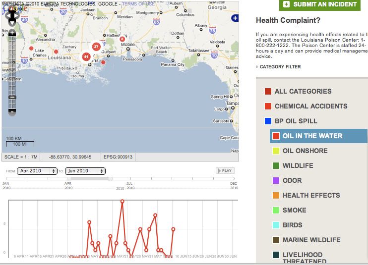
On the same page is a list of reported incidents, in chronological order. These reports, sorted by time and location (GPS or zip code), combine to more powerful evidence than anecdotes. Together, they represent an ever-growing database of the spill's effects on the coast and its residents.
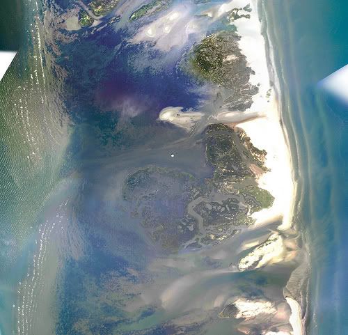
Another fascinating and invaluable effort underway is the Aerial Mapping Project. Using techniques developed by Jeff Warren of MIT Media Lab, teams deploy cameras lofted by weather balloons and kites to photograph an area. The cameras capture images every 3-15 seconds, creating picture-maps with a hundred times the resolution of Google Maps. The Grassroots Mapping concept, and its application to the present crisis, are fascinating. Do take a look.
Here's a composite image of the Chandaleur Islands, already oiled by the spill:
Tools like these will amass invaluable data that entities such as BP, the Coast Guard, etc. may not have the time, resources or inclination to gather. By making their information open source and public domain, the Brigade offers a priceless tool to Coast residents to speed and strengthen their claims against the polluters. Why this is needed is made all too clear by the history of the Exxon Valdez litigation, which was resolved only last year, with the average claimant receiving only $15,000 for the loss of land, health and livelihood.
While some may be troubled by talk of lawyers and litigation, this will be the only way some things from this catastrophe can be made right for Coast residents. Lawyers may not be as popular as cuddly otters, but they will be the heroes in this story, for they are the mercenaries you can buy in a world at war--against you.
The Louisiana Bucket Brigade needs donations and especially volunteers to help with the mapping project and community outreach. As mapping coordinator Shannon Dosemegan said, "We get thousands of emails from people wanting to wash birds. Well, you can't do that. But you can help this effort."
And, hey, you get to fly kites.
(The Brigade also encourages anyone in the area who has seen, heard, smelled or coughed the effects of the spill to use the Oil Spill Crisis Map to report the incidents. I'm delighted to. I was starting to feel pretty stupid with my ongoing oil stink log.)
UPDATE: Please check out Patriot Daily News Clearinghouse's earlier diary on the Brigade and how you can help spread their message here.
