There is a place at the edge of the prairie, just on the southern edge of the Black Hills of South Dakota, where the earth breathes - sometimes inhaling, sometimes exhaling with enough force to blow off your hat! And that's apparently what happened in 1881 when brothers Tom and Jesse Bingham noticed a small hole in the ground.
The Lakota call it "Sacred Breath" or "Breath of Power". In their creation story, it is where the People emerged from their subterranean world into this one. As with the entire Black Hills region, to the Lakota this is a very sacred place.
It is to me, too.
Unassuming, all you see is a 10 x 12" hole in the rock. But stand close when the barometric pressure is high, and hear the hollow, echoing whistle; or when the pressure is low, feel the force of the exiting wind on your face. This alone gives a hint that what lies beyond is something remarkable. It also explains how Wind Cave got its name. As the pressure inside the cave attempts to equalize with the air pressure outside the cave, you can witness it here:
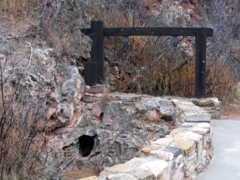
For many years, this was thought to be Wind Cave's only natural opening.
History
Exploration of Wind Cave in the 1880s was minimal. But in the 1890s, the South Dakota Mining company sent J.D. McDonald into the cave seeking - what else? - gold. J.D.'s son Alvin tagged along on the explorations, and kept a diary of his experiences. No precious metals were found, and the mining company lost interest. However, J.D. McDonald saw the cave as a tourist draw, and made a homestead claim at the entrance. He began advertising for tours, making "improvements" such as stairs inside the cave, even removing cave formations to sell. Competing interests (including a former business partner) tried to take control of the cave away from the McDonalds. The dispute became so bitter that in 1899 the General Land Office from the Interior Department sent an agent to investigate. His report stated that because there was neither mining nor farming taking place, neither party had legal claim to the land. This became the basis for Congressional action.
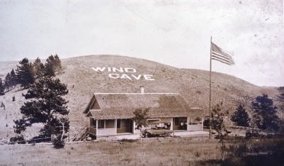 On January 9, 1903, President Teddy Roosevelt designated Wind Cave (map) as our 7th National Park, and the first in the world to protect a cave.
The original 5-8 miles discovered by the explorers of the 1890s remained all that was known of the cave for many years. Groups such as the National Speleological Society, the Colorado Grotto, and the South Dakota School of Mines began a more systematic survey and mapping of this Historic Zone in the 1950s, but did not push much deeper into the cave. That began in earnest in the 1960s, when Herb and Jan Cobb (remember these names) and Dave Schnute made major discoveries, including what is called "the Spillway" - a tight passageway that led to vast new areas of the cave. Further exploration through the 1970s brought the known length of the cave's passageways to well over 30 miles. In 1984, there were two significant events at Wind Cave. The first was the discovery of a second natural entrance - through a nearby cave called the Blowhole, or Snake Pit: two teams of cavers set out - one through Wind Cave's spillway and another through the Blowhole, and managed to find each other deep in the cave through pounding on rocks and shouting. The second event was the completion of Wind Cave's first master map, including all known survey information to date.
Today, there are 135+ miles of known passageways in Wind Cave (2010), making it the fourth longest cave system in the world. What is amazing is that this is all under just one square mile of land! Mathmatical calculations based on air pressure inside and outside the cave and the volume of air moving through the openings predict that this is just the tip of the underground iceberg, with some suggesting the likelihood of Wind Cave physically connecting to Jewel Cave, about 13 miles away.
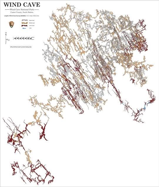
Mapped passages of Wind Cave
Geology
Wind Cave is in the Madison limestone formation (locally called the Pahasapa formation, Paha Sapa being the Lakota words for "Black Hills"), deposited in a shallow sea about 350 million years ago. Time and chemistry worked their magic... with the uplift of the Black Hills (40-60 million years ago) and draining of the water from the limestone setting the stage for the most dramatic cave development.
So... what's so cool about this cave? Aside from the temperature being a consistent 55˚F? Well... let's go find out! Put on some good walking shoes, grab your jacket and flashlight, and for goodness sake, don't touch anything! Cave formations are extraordinarily fragile, even the dust created by tour traffic can settle on delicate crystals and prevent their continued growth. We enter via a sealed elevator shaft so we don't interfere with the natural air circulation in the cave, and tour groups are kept small (sometimes as few as 8). As with most caves, there are enormous rooms. But Wind Cave is also filled with narrow passages and little hidey-holes that pique the imagination. In fact, it is the "densest" (most passage per cubic mile) cave system in the world.
It's not just the rooms and passages and nooks that get our attenti-- oh look! Sparkly!
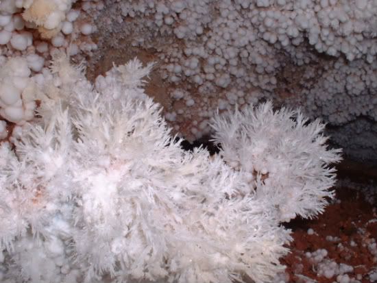
Formations found in Wind Cave include "popcorn" and "frostwork", though these are not the primary formations in the cave.
How did that happen?
From the NPS site: "Most of the speleothems [cave formations] in the cave form by similar processes. The water passes downward through the soil above the limestone, absorbs carbon dioxide, and becomes acidic. As a weak acid, the water is able to dissolve a small amount of the limestone rock as it passes through cracks and pores on its journey down into the cave. As this water drips into the air-filled cave, dissolved carbon dioxide is given off. Because the water has lost carbon dioxide, it cannot hold as much dissolved calcium. The excess calcium is them precipitated on the cave walls and ceilings to make up many of the different kinds of formations. Most calcium is precipitated in the cave as the mineral calcite (CaCO3)."
By far the most abundant formation in Wind Cave is "boxwork" - a formation resulting from cracks in the limestone bedrock that fill with gypsum. The limestone is dissolved away and the gypsum converted to calcite, leaving layers of this intricate crystal that look kinda like... boxes!
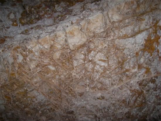
Amazingly, Wind Cave contains about 95% of the world's known boxwork formations.
One of the highlights of every cave tour is the point at which the ranger asks if we'd like to have all the lights turned out... I've yet to be on a tour (5 now) where someone in the group says "no." The blackness is total. Palpable. (I don't have any pictures, though.) For about 30 seconds, it's entertaining. But when a person thinks about what it would be like to lose your light source, "terrifying" is the word that comes to mind - that's why spelunkers carry 3 lights, and never cave alone.
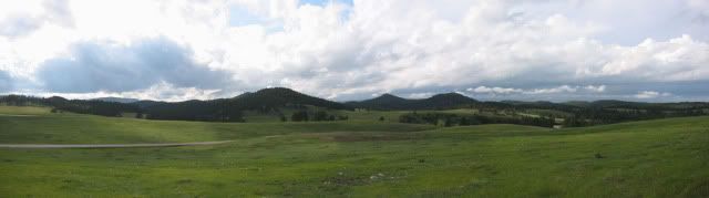
But Wind Cave National Park has a whole other personality - the mixed grass prairie ecosystem above the cave itself.
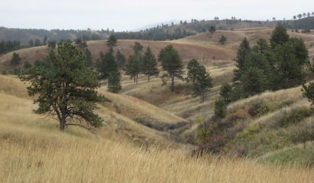
Here the the hard edges of the cave and passages give way to the softness of the rolling hills; the fragility of cave formations yields to the resilient prairie grasses, towering ponderosa pines, and seemingly relentless wind.
There are approximately 30 miles of hiking trails found in the park, which encompasses 28,295 acres. One nice little mile-long loop is the Rankin Ridge nature trail. At the top of the ridge is a fire tower that is sadly no longer open to the public. On my first trip to the park in the early 1990s, I was able to climb the tower and visit with a ranger who had spent many summers in it, looking for smoke. It must be something to sit in the tower and watch those prairie thunderstorms roll in...
Ranging from easy to strenuous, the trails provide access to the majority of the park, but unlike many other parks, here you are encouraged to get off the trail and go wherever your feet take you! Be aware of your surroundings though, because when you get to the top of that rise, you may find yourself staring down a member of the park's bison herd - one of only four genetically pure herds in the world (and currently brucellosis-free).
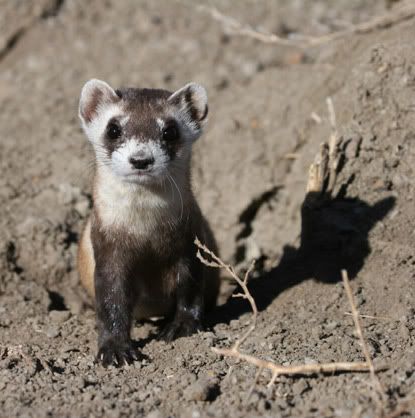
Other mammals frequently seen are mule deer, elk, coyotes, prairie dogs and porcupines; less frequently seen but present are ermine, badgers, and mountain lions. The black-footed ferret, an endangered species, was reintroduced to Wind Cave NP on July 4, 2007, and appears to be holding its own.
For you birders, songbirds and raptors are the most common sightings. Here's a listing of what you might - or might not - expect to find. Oh - and there are snakes. LOTS of snakes, including the Prairie Rattlesnake. So when hiking, take your walking stick and bang it around a lot yelling "no snakes! no snakes here!" just to be safe. It works for me, and amuses the rangers, too.
I'm not forgetting you star-gazers, either... the park has Class I skies, meaning little to no light pollution or haze to diminish your viewing pleasure. I'll admit I've never seen a more amazing night sky than one night at Great Basin NP, but the high prairie skies are pretty awesome, too.
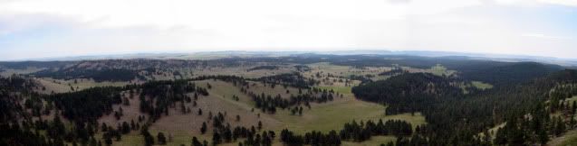
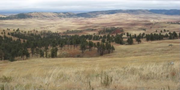
During my most recent vist (2008), I took the backroads through Wind Cave NP, which connected up to the Wildlife Loop Road of Custer State Park. This brought me through the beautiful Red Valley:
Here I spent a long while watching the park's resident elk herd (too far away to photograph with my little camera) and wandering the hills before returning to my campsite at Custer SP.
 Just about 13 miles to the northwest of Wind Cave NP, Jewel Cave National Monument (map) provides an interesting contrast. The land protected is quite small - 1274 acres, compared to Wind Cave's 28,000. But while Wind Cave has 135 mapped miles of passage, Jewel Cave has 153.6, making it the second-longest cave system in the world! (The longest is Mammoth Cave in Kentucky, at an incredible 390 miles.) A full 45% of the passages mapped at Jewel Cave lie outside the national monument boundaries. Amazingly, air flow research on Jewel Cave indicates that only about 2% of the cave system has been mapped to date. It's colder than Wind Cave, too - at only 49˚F.
Given the number of miles in each cave system, their proximity (in both physical distance and geologic formation), and the data indicating how much of each has yet to be discovered, it's no wonder many people believe that eventually the two systems will be linked. When do you suppose that will be... ?
More Geology
But don't think for a minute that the cave systems are similar once you get inside, they're very different. (At least what is seen on tours is different.) While the boxwork, popcorn and frostwork formations in Wind Cave primarily developed during the slow drainage of the system during the Black Hills uplift, the dominant formation in Jewel Cave, "nailhead spar," formed while calcite-laden water was still very slowly circulating through the cave rooms and passages.
"Dogtooth spar" is quite similar to the nailhead spar but has a sharper point to the crystal. Spar formations line virtually every room in Jewel Cave. Another difference I have noticed is that, at least in what is publicly accessible, the rooms are larger - some extraordinarily so - in Jewel Cave.
 Flowstone, uncommon in Wind Cave, is abundant in Jewel Cave. Here you can distinguish the nailhead spar "backdrop" from the flowstone formation. ----->
History at Jewel Cave
Jewel Cave too, was first noticed by brothers - Frank and Albert Michaud - who in 1900 found (you guessed it) a small opening with cold air coming out of it. They, naturally, blasted the opening with dynamite to make it large enough to enter.
The brothers Michaud and family friend Charles Bush found rooms coated with crystals that sparkled like "jewels" from the lights of their lanterns. (Obvious Cave Name #2 of this diary.) The Michauds filed a mining claim on the site knowing the crystals had little monetary value but sensing, like J.D. McDonald at Wind Cave, the potential for a tourist attraction. It was a bust, with tourists few and far between in the region.
But a local movement to protect the cave found greater success, and on February 7, 1908, Jewel Cave National Monument was designated by President Roosevelt. Not long after, the Michaud family sold their mining claim to the government for about $750. Private groups led tours from 1928-39, though administration of the monument was taken over by the NPS in 1933. The CCC accomplished several projects here as well, such as building comfort stations and a surface trail, and modifying the cave opening.
During all this time, the full length of mapped passages in Jewel Cave was only 2 miles. But in 1959, Dwight Deal, a geologist, persuaded a couple of rock-climbing friends - Herb and Jan Conn - to explore with him. In less than two years, the mapped length had grown to 15 miles. It continues to this day.
Jewel Cave is in the Ponderosa pine forest of the southern Black Hills. Or, it was. In 2000, the Jasper Fire burned over 90% of the surface of Jewel Cave NM. Computers and important documents for the monument were actually placed in the cave for protection, since the fire threatened the Visitor Center!
Hikes in the monument range from a short "walk on the roof" to a 5.5 mile loop through Hell Canyon.
Changes in the surface above the cave may be changing the cave itself. A paved parking lot creates a new runoff pattern that may alter water seepage into the cave. Also, the Jasper Fire killed many of the pine trees in the monument, so more rainwater will reach the ground and percolate through to the cave. Who knows what this means for cave formations!
Other Things to Know
* Neither park charges entrance fees. Visitors can drive through, picnic, hike, and enjoy the wildlife for free.
* Fees are charged for cave tours, which range from easy, short "discovery talks" to strenuous "wild caving tours." In all but the easy cases, expect it to be "mildly to moderately strenuous," usually due to a number of stairs. My favorites are the "lantern tours" where each member of the group gets to carry a light - these tours frequently go off the beaten path a bit more than some of the others. I'm sure there will be a tour just right for you!
* Wind Cave NP has a 75-space campground at Elk Mountain (seasonal flush toilets but no showers or hook-ups), Jewel Cave NM has no camping or lodging.
* Summer weather can be hot, with strong storms. Autumn, my favorite season, can be damp and chilly (38˚F and drizzle on my last trip) or warm and sunny. The southern Hills area gets little winter snow (unlike the north) but can have fierce windchills. Finally, spring can be any of the above. But no matter when you're there, count on wind.
I hope you have enjoyed this trip to the edge of the prairie with me - I can't wait to get back. Thanks for reading. And if you don't yet have any plans, National Park Week is April 16-24 - there are no entrance fees at any NPS site - get out and enjoy! (Unless there's a government shutdown, then they'll all be closed...)
This has been the seventh in a series of user contributed features on the national parks. Our previous features are
- Jackson Hole National Monument
- Fort McHenry National Monument and Historic Shrine
- Capitol Reef National Park
- Petrified Forest National Park
- Sequoia and Kings Canyon National Parks
- Dry Tortugas National Park
Next week, Ed in Montana will be writing about Death Valley National Park and the week after will feature musing85 contributing a feature on Zion National Park. If you are interested in writing a feature about a park, please volunteer at our
sign up form and as your window approaches, you'll be contacted (about 3 weeks before) to finalize your date.

