Lot of depressing news, lately: accelerating CO2 emissions, Damascus, Wall Street, that someone like Gingrich could actually be leading the Republican polls. Let's look at some pretty pictures for a bit.
Giant supercell with crepuscular rays
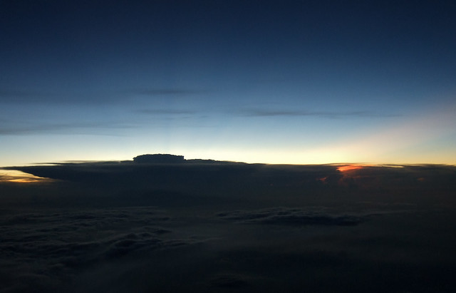
This was taken off southern Taiwan somewhere in July of 2010. Fairly early in the flight so aircraft altitude was relatively low, maybe 10.3 km. What looks rather like an aircraft carrier is an enormous supercell cumulonimbus cloud. The "flight deck" of the carrier is where rising air -- and all clouds are a consequence of rising air -- reaches the tropopause. There the lapse rate turns over and further upward motion is suppressed, and the cloud flattens out into a characteristic "anvil". The "control tower" of the carrier is the overshooting top, the region of updraft in the storm. Normally these look like like little domes on top of the anvil; that this one is so large and well defined indicates seriously immense amounts of energy.
Let's unwind that just a bit. The atmosphere has a well-defined temperature structure with altitude. Here's the so-called "US standard atmosphere":
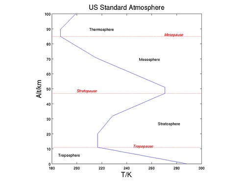
Such a thing doesn't really exist, except in some average sense. Anyway, the things to note are that in the bottom layer it gets colder as you go higher (dT/dz< 0, where z refers to altitude and T to temperature: weather weenies call that a "negative thermal lapse rate"). Warm air rises, so the air column in this region tends to "turn over" relatively quickly ("Troposphere" means "turning over sphere"). The top of the troposphere is the tropopause; above that we get a massive thermal bulge, the bottom of which we call the "stratosphere" and top half the "mesosphere". The stratosphere has a positive lapse rate so is resistant to vertical motion (the warm air is already at the top) -- it is stably stratified. That's why clouds that hit the tropopause tend to flatten out against it, not intrude into the stratosphere. You need a LOT of energy to punch into the stratosphere, which is exactly what happens in the overshooting top. (Note, BTW, that the US standard atmosphere is really only relevant for the middle latitudes: tropopause heights are quite a lot higher in the tropics -- 16-20 km, quite a lot lower at the poles -- 6-8 km, could be a lot lower than that in winter.)
So how big is this thing? Soundings in the general region show tropopause heights of 16-17 km (about 52000-56000 feet, for you Imperial types). In a region of deep convection, such as a Cb, that will likely be a bit higher, call it 18 km. A little scaling shows that the anvil spans something like 250 km across. The overshooting top is some 35 km across and reaches up to 22 km, maybe more (over 72000 ft). This thing is huge, 3-5 times the width of a garden variety supercell, and the energies involved are just mind-bogglingly immense.
Now a question for the learned audience: the beams radiating out from behind the Cb are known as crepuscular rays. To get crepuscular rays you need something to scatter the light. This is easy to find near the surface, such as this example of sea-salt aerosol from the Cliffs of Moher:
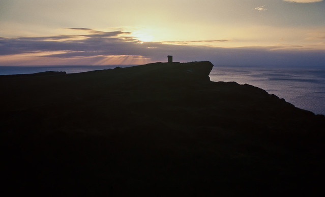
But our supercell is problematic. If we assume that light travels in straight lines, that means that the scatterers are in the stratosphere, which at this latitude is extremely unlikely absent volcanic eruptions. Eyjafjallajokull did erupt that May, on the other side of the world, but its biggest plume reached maybe 9 km, barely half the height of the anvil. The location is no deal-breaker, since there is zonal (east-west) flow in the stratosphere, but the height almost certainly is. There were also eruptions in Java that year, but those were even smaller. Les Cowley at OPOD suggests that the rays are actually refracted downward after passing the supercell, the anvil of which shows us the tropopause height. Now those thin grey clouds in the foreground are above the A/C flight level, and the rays above that, so those rays are at least at 11 km and probably higher, where the ambient pressure is less than 1/4 of the sea level pressure. Not as problematic as crepuscular rays in the stratosphere, but still severely problematic. So the question: what's creating those rays?
Pileus cloud over convection
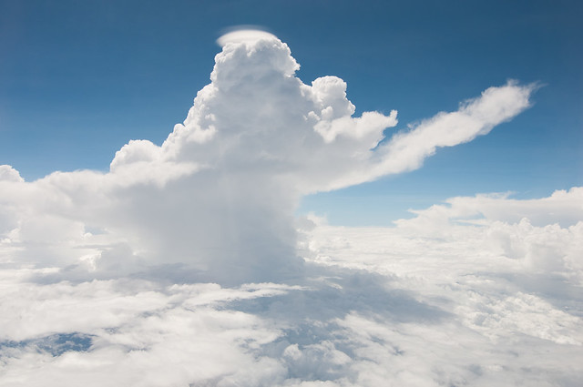
This was taken somewhere over the Java Sea. The tree-like thing in the middle is a column of convection that pretty much exploded from the surface (a little terminology: "convection" = air moving upwards, "subsidence" = air moving downwards, "advection" = air moving sideways, though you and I would probably call that "wind"). The rising air mass has high water vapor content, and since the tropospheric lapse rate is negative, the decreasing temperatures condense the water out, forming the visible cloud. We know the column is very moist because the cloud is so thick. A little above the A/C flight level the column hits a drier, stable air layer. This layer caps the lifting so the column spreads out, except at the core of the lifting, which is evidently energetic enough to punch through the stable layer. As it does so, the core forces the air above it to rise, in this case lifting the drier air high enough that it reaches a temperature where what water vapor there is condenses out. Here, and only here, a cloud forms in this drier layer. It's the lens-like thing that looks (and is) structurally different from the convection that it caps. Weather weenies call this a "pileus" or "cap" cloud, for obvious reasons. Pileus clouds can also form when air with the right moisture content is lifted by an obstruction, such as a mountain, volcanic eruption, or fire plume.
The Intertropical Convergence Zone
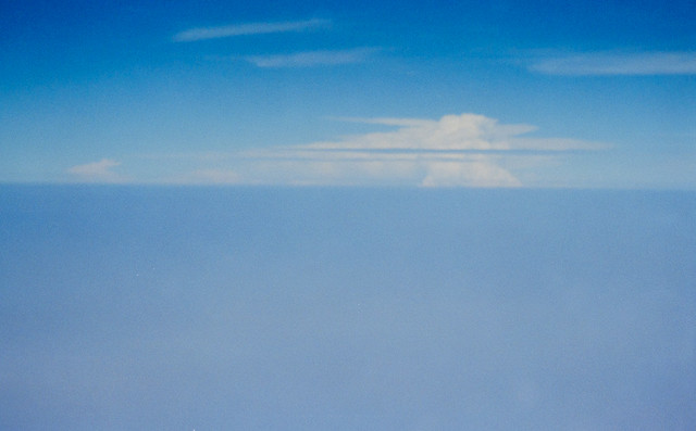
This was taken over the Eastern Pacific, en route from Easter Island to Costa Rica (sorry for the quality: scan from crappy film taken with cheap point-and-shoot shot at low altitude). What you're looking at is where the flow from the Northern and Southern hemispheres come together, the logically named Intertropical Convergence Zone, or ITCZ. The converging air has to go somewhere, and it has nowhere to go but up, so there is a persistent band of deep clouds that tracks the ITCZ. Occasionally there are gaps in the cloud cover, which the A/C was flying through. The clouds in the picture are very deep, probably 18-20 km, and resemble nothing so much as an immense freight train 60000 ft high and 100s of miles long. If you've ever crossed the equator in an airplane, you might have noticed that somewhere near the equator -- where exactly depends on season and location -- there's a bit a rough air and maybe clouds around (the pilot will of course look for the least turbulent way through). You know you have just crossed the ITCZ.
Actually I've got the reasoning backwards. Air does converge at the ITCZ, but that's because that's the region of greatest heating. The warmed air rises, and in so doing drives the great latitudinal circulation cells of the planet. The converging air at the surface closes the circulation loop. Cold air sinks, so you expect subsidence at the poles, and indeed there is a polar high (high pressure = subsidence, since all that air is coming down on top of you). But the circumference of the Earth is some 25000 miles, so the speed of an airmass that's stationary relative to the ground is over 1000 mph at the equator. At the poles, it's 0 mph, and you can't just take 1000 mph air and dump it on the poles: air cannot withstand that kind of shear, so it breaks up into three latitudinal circulation cells in each hemisphere, each spanning some 30 degrees of latitude. The strongest one is the tropical one, known as the Hadley cell. The forcing (heating) is strongest here so it reaches the greatest altitude, which is why the tropopause is so high in the tropics. The polar cell is the weak one: forcing is lowest here and tropopause heights are lowest. In the middle is the midlatitude or sometimes Ferrell cell, which really only exists in a mean sense. This region is quite messed up because this is the region of energy transfer from the tropics to the poles: the tropics take in more solar energy than they radiate out and the poles radiate out more than they take in, so there is net energy transfer from low to high latitudes. Accordingly the boundaries of this cell are very sensitive to the behavior of the Hadley and, especially, polar cells: they don't always go east-west but develop great waves and troughs which drive frontal systems and ultimately the weather patterns which we've come to know and love. BTW, you might expect something strange to happen at the high altitude boundaries of the circulation cells, and you'd be right: you get a narrow strip of air that moves very quickly and is known as the jet stream. BTW2, you might suspect that since what goes up must go down, the subsiding air at the boundaries of the circulation cells should be regions of permanent high pressure and low precipitation. This is true of the poles, of course, but it's also true of the Hadley cells: their subsiding edges are why the great desert belts -- the Mojave, Sonora, Sahara, Chaco, Great Australian, etc -- are all at around 30o latitude.
Speaking of the Ferrell cell ...
Cumulonimbus towers along front
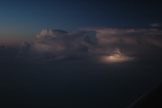
Taken from 35000 ft, this is an awesome line of cumulonimbus towers growing along a cold front. Two airmasses of different properties (temperature, moisture content) meet along a "front", and if they're moving towards each other, the colder/drier one being denser will wedge underneath the warmer moister one. The tropospheric lapse rate is negative, so as the warm airmass rises, the temperature drops until it reaches the point where the water vapor condenses out. Condensation releases a LOT of energy, that heats up the airmass and causes it to rise further, which condenses out more moisture etc etc until the air mass has run out of steam (well, water vapor). If it's a very moist airmass, it might keep rising until it hits the tropopause, where the lapse rate turns over, and the cloud flattens out. You can see how these clouds have done just that: the nearest one has formed an anvil against the tropopause, which over Iowa in May is probably in the 13 km range (these are normal size Cbs, nothing like the monster at the top of the page), the others will shortly. The front is formed by the leading edge of a high pressure system (the "dry conveyor belt") running into a warm air mass.
The Cb nearest the A/C has a couple of intracloud lighting strikes lighting it up (most lightning is intracloud -- cloud to ground strikes account for maybe 5-10% of all events). Updraft velocities in a severe thunderstorm can be very high (100 mph or more in extreme cases -- think how hard you have to blow to keep a baseball-sized hailstone in the air) which typically leads to charge separation. How exactly this happens isn't really well understood. We do know, though, is that air breaks down at around a billion volts/km (depends on humidity, pressure, yes, that's "billion" as in 109). The median peak current is some 20000 Amps. If we scale those lightning bolts in the picture to the height -- maybe 5 km -- and assume medium size bolts, we get something like 1012 W (1 trillion watts -- once the air breaks down the resistance drops ~100 fold). Doesn't last very long, 10-100 microseconds, but that still means ~108 J/pulse. A Cb can have many many lightning strikes, and yet the energy associated with them is but a tiny fraction of the total energy involved.
I'll end this post by
Flying off into the sunset
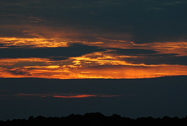
Yet another daily demonstration that light in the presence of particles much smaller than the wavelength of light scatters according to the 4th power of the frequency, a phenomenon known as Rayleigh scattering. Blue light is of higher frequency than red, so it is preferentially scattered by our atmosphere, making skies look blue. At the end (or beginning) of the day, all that blue light scattered out to make someone else's skies blue means that the light that reaches us is skewed red.
But enough of the mathy stuff. The phenomenon is the reality, the math is our way of describing it. Sufficient unto the day is the beauty thereof.
Show us your cloud pics! And do they have stories associated with them?
