About This New Series: Encouraged by some commentators to share more famous landmarks of the Colorado Plateau, that I can and will gladly do. These offerings are mainly intended for a virtual escape from the typical drama and trauma of today’s news. Our community's site and coverage also conveys a lot of same, with the caveat diarists' typically post the most intelligent and insightful news about contemporary times and troubles. Thus a necessity in my view. Still, for those of you who desire a respite from the usual diatribes and polemics, even the spirited pie fights, this series will at least held mitigate the tenor of such an atmosphere, sort of like a literary placebo effect when reading. This is my aim and hope, at least.
The information is presented in the guise of a tourist’s handbook; actually, an informative field guide with authentic (i.e., verifiable and not hyperbole for the sake of self-aggrandizement). The details are also “layered” from the most essential to more in depth details. Therefore the reader absorbs as much or as little of the information predicated on one’s time and interest in the subject matter. It’s also okay to skip some of the details. The point is to have an enjoyable tour and learn what you can and will.
Previous tour diaries, as destinations, in this series were: Glen Canyon and Monument Valley. These URL’s and dates posted can be accessed through my profile.
Kindly Note: All tour information in this series is extrapolated from a larger two-book tome I hope to publish sometime next year, entitled Famous Landmarks Of The Southwest. This magnum opus lists well over one hundred of the most scenic icons relative to the Colorado Plateau’s national parks, national monuments, some state parks, tribal lands (like Monument Valley), and archeological ruins. Hiking trails and slot canyons (details on same) are also in this twin-book index. (The first book list “destinations” and the second book presents “supplements” pertaining to more coverage of key topics that are common to all destinations.). The operative word in the special collection series for the Daily Kos community is extrapolated. This means an abridged account that will cut down on the more lengthy version contained in the ‘Famous Landmarks’ texts. As always, thoughtful and intelligent commentary is highly appreciated. The next installment in the series will be this week's larger Colorado Plateau overview, since its subject matter and explanation has everything to do with all the featured scenic icons presented in this upcoming series. Let's get started on today's tour! (continues after the fold)
Howdy Daily Kos Community: The tour you are about to embark on is headed to the extreme northern edge of the Colorado Plateau; also, to its highest point at nearly 9,000 feet above sea level. That being said, bring a jacket or a sweater along, and for those who suffer from the pangs of asthma and similar other lung-breathing disorders, bring your inhaler. Our destination also has everything to do with the quaint phrase for this diary's title: BRYCE CANYON.
Here's some of what this sector of the Colorado Plateau features:
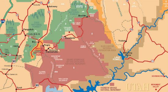
The Setting: For the geographic layout of Bryce, you will find one of the highly recommended must see national parks in Utah (Kane County). Its setting is on the eastern side of the Paunsaugunt Plateau, with an area of 56 square miles. To the northeast by some 50 miles, is another regional must see national park, Zion. Bryce National Park straddles the southeastern edge of the plateau west of the Paunsaugunt fault. The edge of the Kaiparowits Plateau bounds the opposite side of the valley; also overlooks the headwaters of the Paria River (whose drainage features one of the best canyon hallways in southeast, Utah).
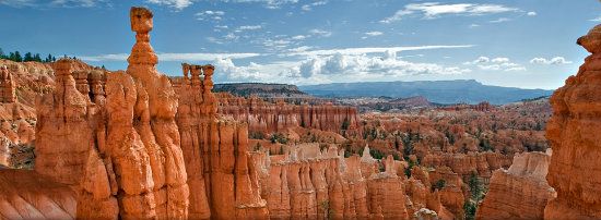
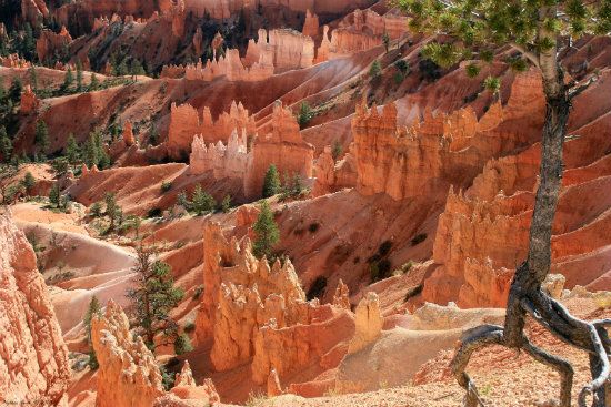
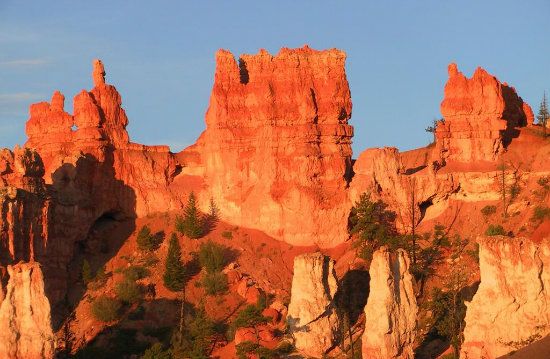
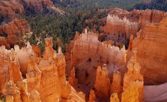
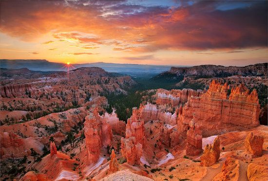
Spotlight (The Abbreviated Essentials): Bryce Canyon denotes a former lake bed and the youngest major geologic masterpiece on the Colorado Plateau (about 1.5 million years). Specifically, a region that is the crowning pink jewell of the so-called Grand Staircase. Late Mesozoic and early Cenozoic foundation deposits. Huge amphitheaters formed by two major regional faults. An engaging geologic setting of colorful hoodoos and spires gracing the highest elevations of the Four Corners region. Water and wind erosion at its finest. In short, Mother Nature done good!
Snapshot: The winsome backdrop of Bryce is visual enchantment to behold (and some call it eye candy). With its brilliant array of colors, shapes, and the sheer size of its broad, gaping amphitheaters, the setting is visceral to the senses as it is majestic. Actually, spellbinding is more like it. Mostly, it is the singularity of Bryce's erosional facade and mineralization process that makes the pink and white limestone layers appear more like a magical fairyland than a geologic backdrop, whose record of depositional materials is relatively recent and spanning the last part of the Cretaceous Period (roughly, 140 to 66 million years ago). Thus the first half of the Cenozoic Era (66 million years ago to the present) began the template of what would one day become a pinkish facade seen and admired today by all visitors. As a designate, Bryce Canyon is a misnomer. It is really classified as an escarpment because there is no canyon profile per se. Technically, an escarpment refers to a steep slope or a series of long cliffs resulting from erosion or faulting separating two relatively level areas of differing elevations. In this case, the Paunsaugunt fault (on the east side) and Sevier (on the west side) fault have dramatically offset this region. (Paunsaugunt, pronounced pawn-suh-gant, is a designate given by the Southern Paiute, meaning home of the beaver.)
From a distance, the backdrop of the elongate Paunsaugunt Plateau commands the view:
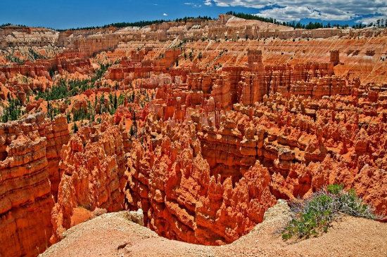
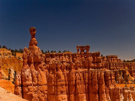
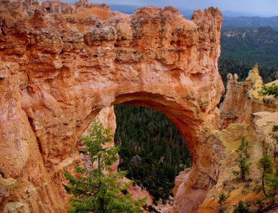
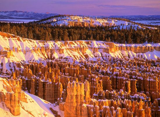
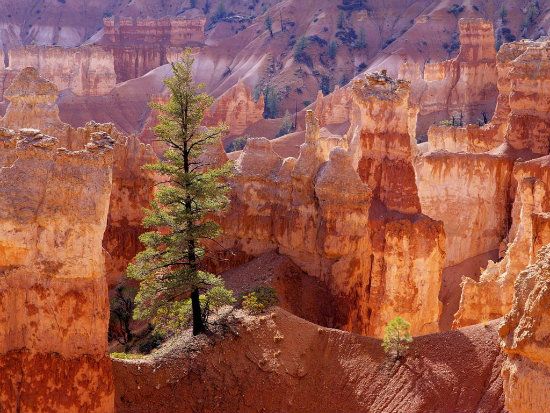
Bryce's utterly distinctive frontage owes its flair and beauty to the aforementioned geological structures called hoodoos (skeletal spires and columns formed by wind, water and ice). The park also has the highest concentration of these whimsical formations on the planet. Composed of soft sedimentary material, each is topped with a harder rock formation that is not easily eroded and therefore protects the columns from the elements (a process called differential erosion). The pinkish, orange and white color adds to the aesthetic appeal, whose tincture is caused by minerals in water. Other geologic features such as arches, natural bridges, walls, and windows also embellish the visual appeal of the backdrop. It is this series of expansive hollows (i.e., amphitheaters) that staggers the imagination, each carved into soft sedimentary rocks that are ideal for erosion. Typically, these freestanding pinnacles define badlands, while the more resistant White Cliffs form monoliths of staggering heights. The setting is further enhanced with towers, turrets, and crenelated ridges. No wonder people fell in love with the place, and later so did the government. Initially, Bryce was a national monument (1923) and later designated Bryce National Park (1928). With such exquisite sculpturing, how could it not be a national park?
Guided Tour Essentials: Unlike other canyons, Bryce was not formed from erosion caused by a stream or river. This means it's technically not a canyon. Instead, the creation of its noteworthy facade stems from a process called headward erosion.
(FYI: Headward erosion is a fluvial process of erosion that lengthens a stream, a valley or a gully at its head and also enlarges its drainage basin. The stream therefore erodes away at the rock and soil at its headwaters in the opposite direction that it flows.)
The result of Bryce Canyon (think "escarpment") has excavated mega amphitheater-shaped features from the side of the Paunsaugunt Plateau. This marvel is a product of the Cenozoic Era. Elevation ranges from 8,000 to 9,000 feet above sea level, making Bryce the highest national park on the Colorado Plateau, including all national monuments. The annual precipitation is also plentiful: 15 to 18 inches. Given above average rain and snowfall accumulation erosion can manage all sorts of visual tricks and treats.
The color scheme here is another major draw complimenting Bryce Canyon's scenic tableau. Indeed, there is a multitude of tinctures entailed in these residue formations: pink and red from hematite (iron oxide), brown, white, yellow from limonite (hydrated iron oxide minerals) and purple from pyrolusite (a mineral consisting essentially of manganese dioxide).
(FYI: For those of you who are rock hounds (I certainly am!), the geology of Bryce represents the Claron Formation deposited in a Paleocene lake (some 66 million years ago). Later in time the region's two major plateaus were lifted thousands of feet exposing the sedimentary landscape to erosion (specifically, headward erosion by branching streams). Factor in repetitive cycles of freezing and thawing, the pelting force of rain and hail, also landslides and wind, and the template of Mother Nature tells the story how Bryce Canyon became the enchanting panorama it is today. The weathering process has also produced its present-day results in a relatively short geological timeframe. Because erosion is relentless, Bryce's profile is receding 9 to 48 inches per century. That's fast work, by the way. The rim of this escarpment, which forms a unique series of incised amphitheaters, is on the dropped side of the Paunsaugunt fault. Nearby Cedar Breaks, which looks similar to Bryce though much smaller in area, developed on the west side of the Markagunt Plateau, which is another Southern Paiute word meaning highland of the trees. Its features drop off along the regional Hurricane fault. This fault represents several thousand feet of movement separating Utah's high country from the adjacent (and much lower) Basin and Range province to the west.)
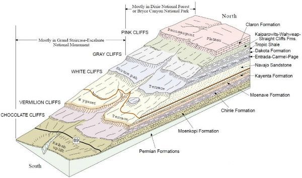
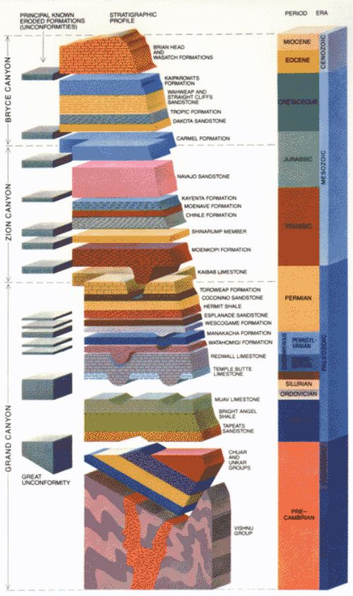
The Wonder of Differential Erosion: Since so much of the Colorado Plateau's features are so wondrously honed by erosion let me also add how the process is unique. Here (like elsewhere throughout the Colorado Plateau territory) the horizontal layers of sandstone, limestone, and siltstone vary in resistance to erosion and is appropriately dubbed differential erosion. This process is thus the master theme of fabrication by erosion, where harder rocks tend to form cliffs and softer rocks form slopes or ledges. The basalt, sandstone and limestone, also dolomite (similar to limestone, except containing magnesium) typifies the more resistant rock formations. In turn, these harder rocks form canyon rims and prominent ledges.
To understand how Bryce was fashioned over time by the elements of erosion, it is also necessary to comprehend how the geophysical mechanics of uplift and the force of downcutting by streams and rivers work in tandem. Indeed, the entire Colorado Plateau province is like an immense layer cake of varying formation that was left out in the rain or snow, then over time gradually fell apart. Faulting, such as happened at Bryce, merely expedited the process.
The Colorado Plateau's horizontal layer cake (stratification):
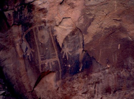
Human History: Petroglyphs in this region indicate human presence dating back several thousand years. Archaeological surveys also confirms evidence people were here as long as 10,000 years ago. Basketmaker Era artifacts are found south of the park. Other artifacts from the varying and ensuing Pueblo Eras add to the archeological treasure trove. (The Puebloans are successors of the Ancestral Puebloans or the so-called "Anasazi" as some people still mistakingly refer to these prehistoric people.) These artifacts also include the Fremont culture up to the mid-Twelfth Century. Southern Paiutes from the Great Basin Culture later moved into the surrounding valleys and plateaus sometime after the aboriginal cultures left (notably the Ancestral Puebloans). This band of the Paiute tribe (the other two being the Northern and Owens Valley Paiutes) believed hoodoos were the Legend People whom the trickster "Coyote" had turned to stone.
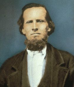
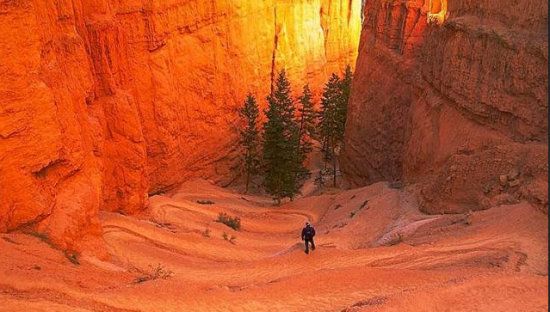
Much later in time Mormons, the first Anglicized emigrants into the West, entered the region during the mid-Nineteenth Century (in the 1850s). Ebenezer Bryce homesteaded here in 1874 and grazed cattle inside Bryce's convoluted terrain. He's quoted as telling a visitor how the setting was a helluva place to lose a cow! (And now you know the meaning and source behind the diary's singular subject title!) Eventually, he may have grown tired of losing tract of his livestock and left the area in 1880 to homestead and ranch in Arizona. By the early-Twentieth Century, Bryce gained popularity from which followed the area's eventual development into a national park. It's also no wonder Ebenezer Bryce. . .
gave up grazing cattle here, because it really was difficult to find his wandering stock:
Flora And Fauna: Mule deer are the most common large animals found in and around the park. More than four hundred native plant species also thrive here, ranging in three distinct life zones based on elevation gradients: Transition, Canadian and Hudsonian. Pinon pine and juniper to blue spruce and Douglas-fir are the dominant species. In the harshest areas, Great Basin bristlecone pine are also found, some dating from more than 1,600 years ago (making this life form the oldest on the continent). With as much precipitation this region annually gets, there is an abundance of black and lumpy cryptobiotic soil (a.k.a. cyanobacteria) and a lively mix of lichens, algae and fungi. These are all vital organisms that retard erosion, add nitrogen to soil and help retain moisture. Forests and meadows provide the main habitat to support such diverse animal life, from a variety of avians to small mammals. The apex predators, like foxes, coyotes, the occasional bobcats, mountain lions are also present. Black bears, elk or deer, and pronghorn antelope (the fastest animal in North America) sometime venture into the park. About 177 species of birds visit here each year, but only the heartiest remain year-round. For instance, the ubiquitous and opportunistic ravens and jays. Swifts and swallows are also a dominant species. Eagles and owls are equally common. There are eleven species of reptiles and four species of amphibians that add to the rich roster of life forms in this region. Because of the harsh, cold winters most species migrate to warmer regions until spring.
Fair warning: I may be a small critter, but guess who gets most of the food stuff from inattentive campers in my domain?
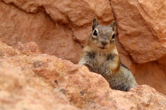
Folks, don't believe that little rat with a tail. . .we ravens are much smarter when it comes to, well let's just say, usurping camper stuff. Believe it!

Bonus Details: From a distance, the size of hoodoos is misleading. In reality, these inspiring formations measure up to 200 feet high. Amphitheaters are also huge and extend more than 20 miles from north to south. The largest is Bryce Amphitheater: 12 miles long, 3 miles wide and 800 feet deep. Rainbow Point is the highest sector of the park––9,105 feet. Yellow Creek is lowest in elevation––6,620 feet.

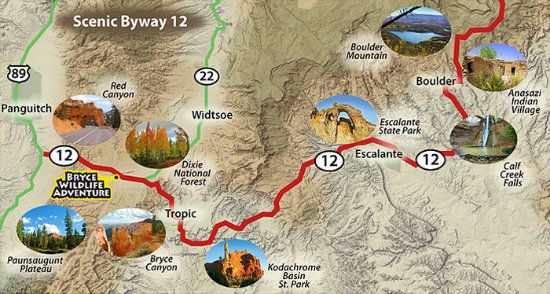
For Those Of You Who Enjoy Hiking: When visiting the park, and if you are in decent physical shape to do it, go take a hike! Bryce offers eight marked and maintained hiking trails. Most of the trails can be hiked in less than a day (a round-trip estimate). Most are also loop trails, ranging between one and two hours and up to four and five hours: Mossy Cave, Rim Trail, Bristlecone Loop, and Queens Garden are easy-to-moderate hikes. Navajo Loop and Tower Bridge are moderate hikes. Fairyland Loop and Peekaboo Loop are strenuous hikes. Several of these trails intersect, allowing hikers to combine routes for more challenging hikes. There are also two trails designated for overnight hiking: the 9-mile Riggs Loop Trail and the 23-mile Under the Rim Trail. Both require a backcountry camping permit. Combined, there are 50 miles of trails in the park. Whose up for a hike?
Conclusion: I hope this educational tour-de-force was enjoyable. The information given on the tour is also geared to many levels of interest. I just share it all, and like I say about the life process being akin to a shopping spree, take what you want and leave go of the rest. Still, you at least have reliable knowledge of the what-how-when-and-why factors. Who knows: some of you may even want to make a fast buck or two and hang out at one of Bryce's many prominent overlooks and maybe see if you can get a tour group going. If so, you might get lucky with the gratuity thing.
As for the where factor. . .if you are coming from the North Rim of the Grand Canyon and driving through Kanab, Utah, take Hwy. 67 north, then connect to Hwy. 89 (north) through Page and Kanab. Continue on this route to Hwy. 12. Take this route to Hwy. 67, then Hwy. 63 south into Bryce. Total distance 167 miles (269 km) and close to four hours.
For contact information: Bryce Canyon NP, P. O. Box 640201, Bryce UT 84764-0201. Phone (visitor information): 435-834.5322. As of this posting, Fax or Email non-listed.
As always, thoughtful and intelligent commentary is welcomed!
Rich