Super Cyclone Phalin Intensified Extraordinarily Rapidly to Category 5, 165mph Winds. However, India's Meteorology Department has not kept up with the intensification reported by the Joint Typhoon Warning Center so Indians are not fully prepared.
Super Cyclone Phailin may be more powerful than hurricane Katrina because it is maintaining it's strength as it approaches land. Maximum wave heights estimated by the Joint Typhoon Warning center are 56 feet. However, the India Meteorology Department has not recognized how much Phailin has strengthened.
NEW DELHI: The weather office may be underestimating the severity of a cyclone which is hurtling towards the east coast, a meteorologist warned on Friday, adding that it could be worse than Hurricane Katrina which devastated parts of the United States in 2005.
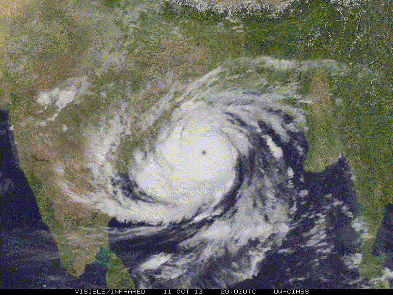
Cyclone Phailin is forecast to hit the coast between Kalingapatnam in Andhra Pradesh and Paradip in Odisha late on Saturday with a maximum wind speed of 220kmph (135mph), the India Meteorological Department (IMD) said in its latest bulletin. However, both London-based Tropical Storm and the US navy's Joint Typhoon Warning Centre forecast winds reaching 315kmph (195mph) on landfall, classifying Phailin as a Category 5 storm — the most powerful .
---------- Update-----------------------------------------
Phailin made landfall around sunset, but winds peaked out before landfall because a new eyewall cycle had started. The new eyewall was not able to form because it was disrupted by land, but the partial formation of the new eyewall sapped energy from the inner eyewall. India got a break.
More than half a million people were evacuated from the lo coastal areas of Odisha.
Meanwhile, Vikram Pradhan, Joint Resident Commissioner of Odisha Bhavan in Delhi said that more than 4,48,000 people have been evacuated.
He said, unlike the last time people were more forthcoming in the evacuation exercise as most are aware of the experience of the 1999 super cyclone. ...
“Our main focus is to avoid loss of human life. So far we have evacuated 4.25 lakh people in Odisha and 1 lakh more in Andhra Pradesh,” Union Home Secretary Anil Goswami told reporters in Delhi.
Most of the evacuated people have been sheltered in 500 specially—built cyclone camps in the two states. Each cyclone shelter can accommodate up to 1,500 people while their ground floors may be used as cattle shelters.
Uploaded with
ImageShack.us
More good news about this storm is that it is came ashore on a coastline where the terrain rises steadily above sea level moving inland.
-------------------------------- end update -------------------------
The storm surge which could be as high as 5 to 6 meters, about 20 ft maximum, will do far less damage on this shoreline than the devastating 1999 cyclone did on lowlands to the north. Jeff Masters at Wunderground has made a map showing this good news.
Figure 2. Elevation of the Odisha region of India, with the track of the 1999 Odisha cyclone and forecast track of Phailin overlaid. Phailin is predicted to hit a region of the coast about 100 miles to the southwest of where the 1999 cyclone hit. The coast is not as low-lying to the southwest, which should result in a lower storm surge death toll. The greatest storm surge occurs along the coast to the right of where the center crosses. Image credit: http://www.globalwarmingart.com
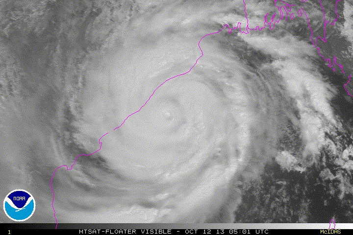
University of Wisconsin CIMSS morphed microwave imagery shows Phailin strengthening while approaching India after completing an eyewall replacement cycle. Another cycle is unlikely to take place because the outer bands that would form the new eyewall are now being disrupted by land.
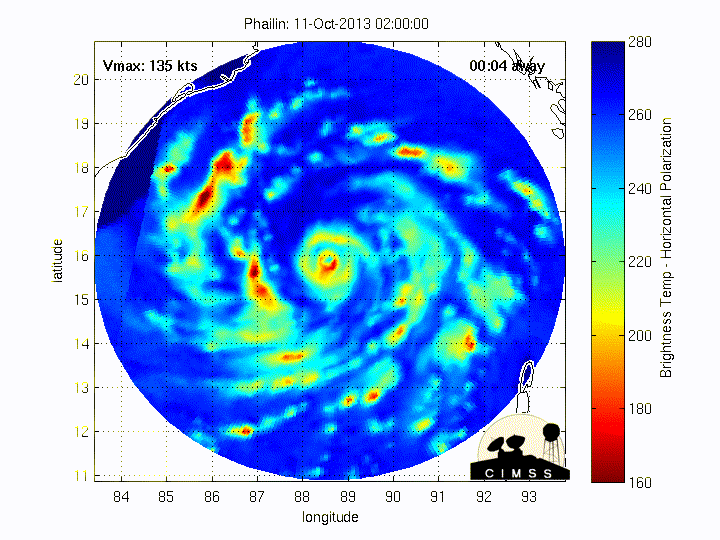
At 0Z (GMT) Saturday the 13th JTWC determined that the central pressure of Phailin was an exceptionally low 898 mb.
TROPICAL CYCLONE 02B 0:00UTC 12October2013
UW-CIMSS Experimental Vertical Shear and TC Intensity Trend Estimates
Current Conditions (from JTWC) :
Latitude : 17:30:06 N
Longitude : 86:29:14 E
Intensity (MSLP) : 898.0 hPa
A large area of heavy rain, as much as 20 inches will move inland as the storm dissipates over the next 48 hours after landfall. Flooding will cause extensive damage over a large area as Phalin's remnants move up slope towards the Himalayas. Tropical systems moving upslope often dump enormous amounts of rain. This is an exceptionally dangerous situation that India does not appear to have adequately prepared for in time because of Phalin's exceptionally rapid intensification.


