The slow melt of the Antarctica should come as no surprise to most of us here. Back in November I wrote this diary. The diary in a nutshell scientists suspected that the spatial pattern of a recently collapsed Iceberg B-31, strongly suggested that the cause of this change is "weaker ice shelves, the floating apron of ice that fringe the perimeter of the ice sheet. Our hypothesis is that warm water is melting the undersides of these ice shelves decreasing the "back pressure" from the ice shelves to help hold the ice sheet. Less backpressure means the ice sheet can flow faster".
What scientists see now is that the massive 68,000-square-mile sheet of ice, believed to be the biggest single contributor to sea-level rise in Antarctica, has begun to shed water at a rate not seen before.
IBT reports:
An international team of scientists from the CSC-IT Center for Science in Finland, the Chinese Academy of Sciences and the Universities of Exeter and Bristol combined field observations and computer models to forecast how the ice will change over the coming decades. They concluded that the Pine Island Glacier has “started a phase of self-sustained retreat and will irreversibly continue its decline,” according to Gael Durand, a glaciologist from France. Scientists believe the glacier is capable of losing up to 100 billion tons of water a year, the equivalent of about a 10mm rise in global sea levels by 2034.
“The Pine Island Glacier shows the biggest changes in this area at the moment, but if it is unstable, it may have implications for the entire West Antarctic Ice Sheet," Dr. G. Hilmar Gudmundsson, who works for the British Antarctic Survey and was a researcher on the project, said in a statement. “At the Pine Island Glacier, we have seen that not only is more ice flowing from the glacier into the ocean, but it's also flowing faster across the grounding line -- the [underwater] boundary between the grounded ice and the floating ice. We also can see this boundary is migrating further inland.”
NASA Earth Observatory
"Antarctica is poised to impact human life around the globe. Sea levels are rising in part because land-based ice is melting. Rising sea levels increase coastal erosion and flooding. And one of the largest single contributors to sea level rise in recent years is Antarctica’s Pine Island Glacier. Shrinking at a rate of 100 meters (300 feet) per year, the Pine Island Glacier is responsible for seven percent of the world’s recent sea level rise. Why is the Pine Island Glacier melting so quickly?"
In October 2009, a series of flights over Antarctica led to the discovery of a hidden feature beneath a floating ice shelf. Scientists participating in NASA’s Operation IceBridge mapped the water depth and seafloor topography beneath Pine Island Glacier and found a deepwater channel—a likely pathway for warm water to reach the glacier’s underbelly and melt it from below.
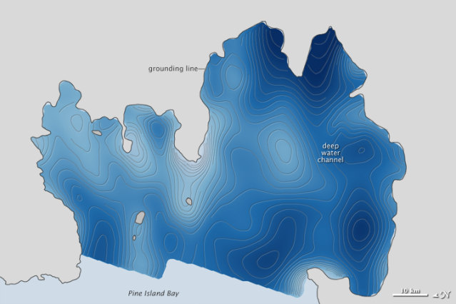
The top image above shows the bathymetry—the height and depth of the seafloor—beneath Pine Island Glacier. The deepest regions (navy blue) descend about 1,200 meters (3,900 feet) below sea level, while elevated seamounts and shoals (pale blue to white) are mostly 200 meters (650 feet) below sea level.
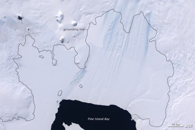
The second image shows Pine Island Glacier and the surrounding solid land in Antarctica as they appear from space. The view is a subset of the Landsat Image Mosaic of Antarctica, the first true-color, high-resolution visual map of Antarctica. The black, jagged outline in both images shows the “grounding line,” the point where the glacier is attached to the bedrock along the coast.
According to NASA-Unstable Antarctic: What's driving Ice Loss?
Taking a closer look at Antarctica's Pine Island Glacier is Michael Studinger, a glaciologist with the Goddard Earth Sciences and Technology Center at NASA Goddard.
Studinger is project scientist for NASA's Operation IceBridge mission -- an airborne science campaign that makes annual surveys of polar snow and ice -- that is helping researchers understand changes to Pine Island and other critical regions along West Antarctica and the Peninsula.
After analyzing data from the mission's first Antarctic deployment in 2009, the team revealed for the first time a curious feature below the Pine Island shelf: a sinuous channel that allows warm ocean water to reach the grounding line, leading to melting of the ice shelf from below.
More information will become available throughout Operation IceBridge, which sustains watch over Earth's poles until the launch of ICESat-2, scheduled for January 2016. In November 2010, teams concluded the second Antarctic campaign during which they flew over sea ice and key glaciers including a return mission over Pine Island Glacier. These data will be incorporated into the tools scientists use to refine estimates of future sea level rise.
Short NASA Video on Pine Island ice sheet melt.
http://www.youtube.com/...

