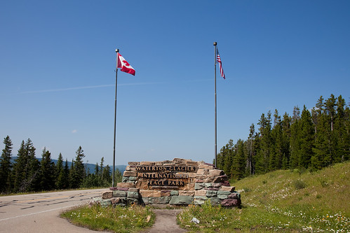
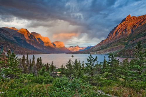
Straddling the border Montana and Alberta lies the worlds' first international park, the Waterton-Glacier International Peace Park consisting of Glacier National Park in the United States and Waterton Lakes National Park (Parc national des Lacs-Waterton) in Canada. Though the parks are maintained independently of each other by each national's government, the parks were symbolically joined into one in 1932 and appear on the United Nation's list of World Heritage Sites and Biosphere Reserves as a single unit. Once home of the Blackfoot Indians, today the park is home to millions of visitors drawn to the spectacular glacial carved landscape and the vast array of wildlife.
(Sorry its a bit late. Was on a call most of the morning and couldn't put the finishing touches on until lunch time. Sorry it is a bit photo heavy too, but OMG, trust me and the photos, just go here.-craigkg)
Getting There
The closest airport to the park is Glacier Park Airport located between Kalispell and Columbia Falls, Montana, just 24 miles southwest of the park entrance at West Glacier Village. Other nearby airports include those at Missoula (132 miles from West Glacier), Great Falls (140 miles from East Glacier Park Village) and Calgary (174 miles to Waterton Townsite). For my family's trip to Glacier, my brother convinced us to fly into Spokane so we could take the scenic drive along US Hwy 2. Given the scenery you get in Glacier and Waterton Lakes, I don't think it is worth it given that you are almost 300 miles from the parks flying into Spokane.
If you want to be very traditional, you can arrive in Glacier National Park the same way the early visitors to the park arrived...taking the train. The Great Northern Railway had stops at East and West Glacier back in the day. The tracks are still there and in use by Amtrak. From the rail depot at East Glacier, you can still walk from the depot up the landscaped walkway into the Glacier Park Lodge.
|
The Glacier Park Amtrak station as viewed down the landscape garden way from the Glacier Park Lodge.
|
While having a car helps in getting to the sites in the park, if you want to go carless for your trip to Waterton-Glacier, it can be done with some caveats. The park has a shuttle system in the summer months running roughly every 15-30 minutes from 7 to 7, but this shuttle only travels the 48 miles of the famed Going-to-the-Sun Road between the St. Mary Visitor Center and the Apgar Transit Center. It does not go to West Glacier, East Glacier Park or Many Glacier. However, if you took the train, you aren't stuck in East Glacier. More on this below.
Where to Stay
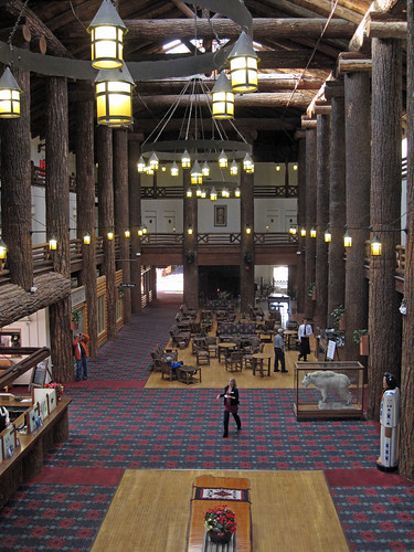
Glacier is home to some of the oldest park lodges in the park system. The Glacier Park Lodge was built in 1912. The McDonald Lodge and Many Glacier Hotel were built in 1914. The Prince of Wales Hotel was constructed in 1927.
|
Lobby of the Glacier Park Lodge with its massive log pillars. Built by the Great Northern Railway as their showcase resort to attract visitors to the park.
|
|
|
McDonald Lodge on the southern shores of Lake McDonald on the Going-to-the-Sun Road.
|
|
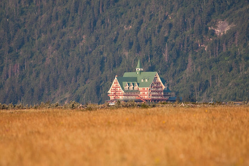
|
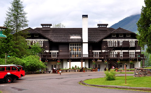
Prince of Wales Hotel in Waterton Lakes Natl Park from a distance
|
Less stately than these imposing lodges are the Swiftcurrent Motor Inn and the Rising Sun Motor Inn built in 1933 and 1940 respectively and the Village Inn at Apgar built in 1956.
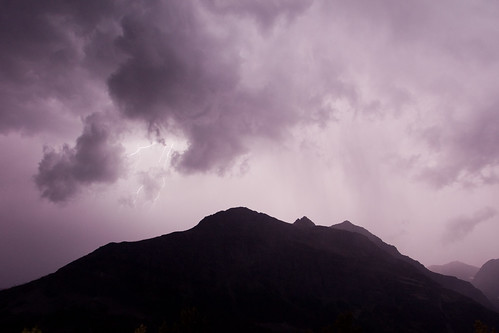
|
Lightning from a storm taken as my parents and I sat on the front porch of the Rising Sun Motor Inn our first night in Glacier.
|
All of these are located in the park boundaries with the exception of the Glacier Park Lodge (ironic I know) just outside the park at the park's southeast corner. Reservations at all these properties can be made through the Park's concessionaire
Glacier Park, Inc. There are many other lodging options in West Glacier, East Glacier, St. Mary, Columbia Falls and Waterton. Backcountry hikers have two additional options, the Sperry and Granite Park Chalets nestled deep in the high country of the park, accessible only by hiking trail. Granite Park Chalet is most easily accessed by a 4.2 mile trail with 2300 feet of elevation gain though other longer routes are possible. The hike to Sperry Chalet is more taxing, 6.7 miles with 3300 feet of gain.
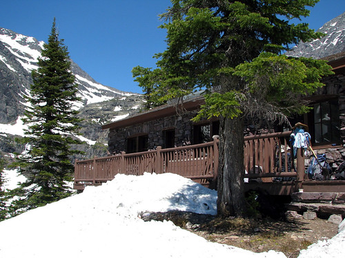
|
Sperry Chalet accessible only by hiking
|
Campers have a plethora of campsites to choose from in the park with 13 front country campgrounds.
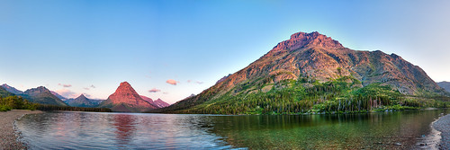
|
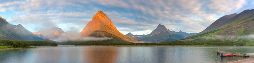
Sunrise at Two Medicine Lake from the Two Medicine campground. Wouldn't you like to wake up to this kinda of view!?
|
Whereas most parks have a central lodge where one can stay most of the trip and then radiate out to the sites of the park, Waterton-Glacier doesn't fit this model. The lodging is along the perimeter of the park for the most part, conducive to going from lodge to lodge for each night of your trip for longer trips. Moreover the geography is such that staying the entire trip at one lodge will mean much more driving to get to your destination/activities. And you should visit all the historic lodges anyway as they are destinations unto themselves. On my trip to the park, we had intended to stay one night at McDonald Lodge, two nights at Rising Sun, one night at Many Glacier, two nights in Waterton and one night in East Glacier. Unfortunately McDonald Lodge and the Village Inn were booked up and we had to spend the first three nights at Rising Sun making access to the west side of the park more difficult.
|
Sunrise from the back deck of the Many Glacier Hotel with a view on Swiftcurrent Lake and Grinnell Point
|
Bye bye Glaciers
Glacier National Park was so named because it is a prime example of the affect of glaciation. Several guide on our trip (a ranger and the red bus driver) said the park can be summed up in three words: Sedimentation, uplift and glaciation. The rock in Glacier is some of the oldest in the world. Many visitors are surprised however that there are no fossils in the rock even though they are mostly sedimentary. That is a testament to how old the rick is...it is older than most life on the planet. The only known fossils found in the park are of stromatolites, ancient colonies of bacteria. In 1850, the area that is now Glacier National Park had over 150 glaciers. When Glacier National Park was created in 1910, there were still over 100 glaciers. Today, just over 100 years later, the number has shrunk to just over 20 and they are melting so fast it is estimated they could be gone as soon as 2020 and by 2030 at the latest. As things stand now, most park visitors barely catch a glimpse of a glacier in the park as most are tucked away in places people don't often visit. The exceptions are the Jackson and Blackfoot Glaciers visible from the Going-to-the-Sun Road and the Sperry Glacier above the Chalet on Gunsight Mountain. Grinnell Glacier's melt has formed, in the last century, a new lake in the park. A hike from Many Glacier will take you up to this new lake and offer majestic views down to the original or lower Grinnell Lake, displaying its characteristic turquoise color cause by rock flour, the fine particulate suspended in the water from the grinding of rock by the glaciers. It is common to see this affect in many of Glacier's lakes and stream, but within 20-30 years of the glaciers' demise, the particulate, no longer been resupplied by glaciation, will settle and the beautiful colors of the lakes will disappear into regular blue waters.
What to See and Do
Red Bus Tours
OK, if you are a nut for all things old and sightseeing is your thing, stop, pick up the phone, call Glacier Park, Inc and reserve your seat on one of the Red Bus Tours. These tours are done in 1936-39 model White Motor Company touring 17 passenger vehicles with canvas roll top covers. On nice days they roll it back and you have gorgeous views of the mountains not just out your window, but above you as well. Your driver, known as jammers, gives narration along the way. The vehicles were and restored and refitted to run on natural gas a few years ago to extend their life so more and more visitors can see the park as early visitors had. On many tours you have stops for lunch or at particular sites. The popular Crown of the Continent tour my family went on stops at Wild Goose Island Overlook, Sun Point, Logan Pass atop the Going-to-the-Sun Road for a brief visit to the visitor center there and at the McDonald Lodge where you can have lunch at the Lodge's dining room, the pizzeria or get your own food at the general store. Tours start all around the parks and run as little as $30. If you arrived by train, don't want to rent a car to get around and/or don't mind being on a structured tour, the Red Buses are an excellent option to see the park with trips into Waterton Lakes, Many Glacier, along the Going-to-the-Sun Road, Two Medicine and along the road over Marias Pass.
|
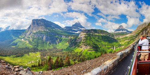
A panoramic view of the Reynolds Creek Valley from one of the red buses as it stopped at a turnout along the Going-to-the-Sun Road. We had great weather for our tour, top rolled back allowing riders to stand up in the vehicle when the vehicle has come to a complete stop. Wave "hi" to my brother Ed talking a picture.
|
Going-to-the-Sun Road
I've mentioned it a few times already, and you are probably wonder, "What is so special about this Going-to-the-Sun Road?" It isn't often that a road is one of the star attractions of a park, but the Going-to-the-Sun Road is no ordinary road. It is the only road that traverses the park through the park, going through the spectacular scenery of the mountains and valleys. The road is only open for about three months a year. The rest of the year it sits entombed beneath drifts of snow that can tower over 100 feet tall. To facilitate the clearing process, rather than routing the road through the McDonald Valley and the Reynolds Creek Valley with a series of switchbacks to climb the mountain at the pass, the road was cut into the southern face of the mountains, gently climbing with only one switchback. This causes the road to be higher in elevation and being on the southern face, gives to road more sun exposure, which helps facilitate snow melt on the 100+ foot snow drifts, reducing the amount of work that has to be done with the snow plows are brought in to complete the clearing of the road, a process than can take months each year. When the snow plows on the east side start their work, the first step in the process is to send out a survey crew to locate the tower on the visitor center at the pass. Did I mention the road can get covered by 100+ feet of snow? The tower serves as a reference point for the snow plow crews as their work has to be precise. One small mistake and the plow could fall off the road down the side of the mountain. The portions of the road that get the highest snow fall and have the highest possibility of avalanches do not have guard rails as an avalanche could pull the road right off the mountain with guard rails installed. Some stretches have low stone walls built with stone from the excavated roadway while others get lumber beams fastened into place as guard rails once the road is clear.
From the road you get some of the best sights in the park. And along the way, there are several places to stop get a better view or take a hike. At the west end of the road that gets closed each year is the Avalanche Creek trail. This hike takes you up into a cirque of the mountains with a glacier fed lake at the top. The outflow of the lake forms a creek that in places has slowly carved a small and strikingly beautiful gorge through some of the oldest rocks on earth.
|
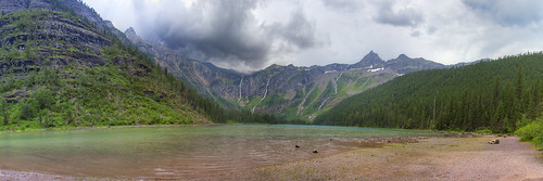
A storm gathering over Avalanche Lake at the top of the Avalanche Lake Trail. Yes, I got thoroughly soaked when the storm hit on the hike down. it was clear skies when I started the hike. Gotta love that mountain weather.
|
|
|
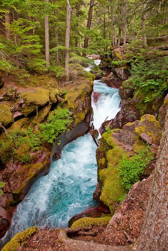
Avalanche Gorge along the Avalanche Lake Trail. BTW, that water is figid. It is glacial fed afterall. Just a warning. ;-)
|
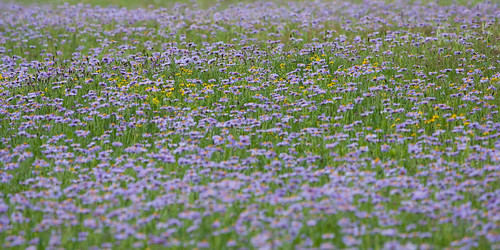
A much shorter nature trail takes visitors through a lovely old growth cedar forest. Heading east up the road, the next major site is the road's only switchback, the Loop, where several trails begin, including the hike to the Granite Park Chalet. Climbing further up the road are the Weeping Wall, where water from snow melt cascades off the rock face next to the road onto cars. You can also turn out for Haystack Falls, a water fall next to the road, and for a better sight of Bird Woman Falls on the opposite side of the valley as it falls from a cirque formed by Clements Mountain and Mount Oberlin and of the triple arches, a bridge that had to be built on the mountainside to complete the road. The three arches of the bridge are said to commemorate the three men that died in the process of constructing the road. At the road's summit is Logan Pass. If you like wildflowers, this is a dream land. Throughout the summer, different flowers bloom is a changing cascade of color, blanketing the pass area after the snows recede.
|
A field of subalpine fleabanes were blanketing the meadow oustide the Logan Pass visitor center. Interspersed are occasional cinquefoil, golden aster and paintbrushes.
|
|
|
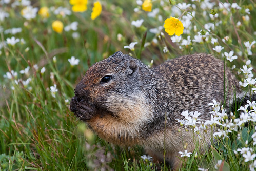
A Columbian ground squirrel feasts on some roots he dug up in the meadow at Logan Pass surrounded by flowers.
|
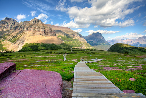
A trail (that is a boardwalk most of the way) from the visitor center here goes up the gentle incline of the pass to a viewpoint where hikers can see hidden lake, nestled between several mountains.
|
Descending the Hidden Lake Trail on the boardwalk back to the visitor center. The purple rocks are part of the Grinnell formation and were formed by sedimentation of an ancient seas that periodically dried up and whose surface cracked and was filled in by other wind borne sediments in a process that repeated itself over and over. That's why you see little white crisscrosses in the rock.
|
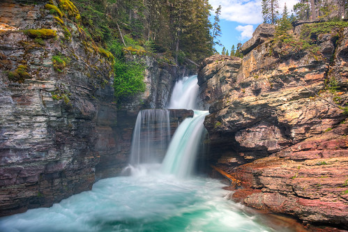
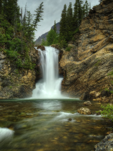
Descending the pass still heading east, you go through the tunnel with view portals cut out to let in light. To the south is the spectacular view of the Reynolds Creek Valley and a waterfall dropping from the Logan Pass into the valley. At Siyeh Bend is a trailhead for a couple of trails along with a parking area to take in the views. Further downare a series of trails that take you to magnificent waterfalls and views of St. Mary Lake. I can highly recommend the St Mary Falls trail. It isn't long and the waterfall is one of my favorites.
|
St Mary Falls is easily accessible by a relatively short trail off the Going-to-the-Sun Road.
|
The trail also continues to Virginia Falls. At Sunrift Gorge, you get views of another creek carved gorge, exposing a panoply of colors in the rock. Sun Point is a protrusion into the lake offering stellar views. Finally, as the road approaches Rising Sun is Wild Goose Island Overlook, a viewpoint overlooking a tiny island in the lake where Indian legend says two lovers from different warring tribes were marooned for their final goodbye before they would be forced to never see each other again. The Great Spirit, however, saw their love and turned them into geese, a bird that mates for life and they were able to fly away and be together forever.
|
Sunrise at Wild Goose Island Overlook. This is why landscape photographers get up at ungodly hours to be in place for sunrise.
|
Won't You Let Me Take You On A Sea Lake Cruise
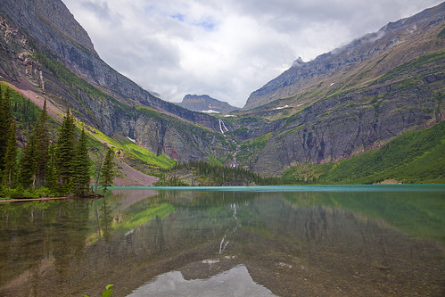
One of the more popular things to do in the park is to take scenic cruises on the historic old boats on the largest lakes of the parks. Many included guided hikes from the docks on the opposite ends of the lake. Our family took the one from the Many Glacier Hotel riding the Chief Two Guns on Swiftcurrent Lake to the opposite shore, hiked 400 yards over a small hill (the highest elevation gain on the trip-hike) to the dock to board the Morning Eagle for a boat ride across Lake Josephine to a trailhead that takes you one level mile to Grinnell Lake and a view of the Grinnell falls where water from Upper Grinnell Lake (formed in the last century from glacial melt) cascades over the ridge into Grinnell Lake. Up on the mountain we saw small white specs, otherwise known as mountain goats. Along the trail were many huckleberry bushes, some with berries no bear had yet consumed. The hike was guided by a Ranger-Naturalist.
|
Grinnell Lake with Grinnell Falls flowing down the mountain. You can see some of the turquoise color of the lake at the far end of the surface.
|
On Lake McDonald, you can take the flagship of the historic wooden boats, the
DeSmet. The evening tour at 7pm is popular for the view of the sunset over the lake. On St Mary Lake, the
Little Chief will take you by Wild Goose Island and with the hiking option, you can visit St Mary Falls. The boat tour on
Sinopah at Two Medicine also offers a hiking option on the trail to Twin Falls. In Waterton, the
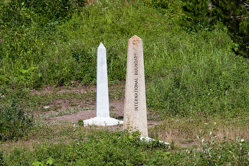
MV International ferries visitors from Waterton Townsite up the length of Upper Waterton Lake, over the International border into the U.S. to a Peace Pavilion at Goat Haunt at the head of the lake. Hikers wishing to go to Rainbow Falls or take the backpacking hike to Many Glacier must pass through the U.S. Customs checkpoint. At the pavilion, you get about 45 minutes to have a picnic and see some displays on the symbolic union of the two parks before boarding the boat back into Canada to Waterton.
|
Markers for the international border between the U.S. and Canada as seen from the MV International as it cruised Upper Waterton Lake.
|
Miles and Miles of Trails
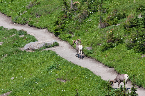
Glacier and Waterton Lakes are hiker's paradises. It doesn't matter if you want short easy trails, or long, multi-day backpack hikes with lots of elevation change, there is a trail (or trails) for you here. I've already mentioned a few at Avalanche Creek, the boardwalk to Hidden Lake Overlook, the trail to Grinnell Lake, the trails to the Chalets, the hike to St Mary and Virginia Falls, etc. One additional trail worth noting, not for the faint of heart, is the Highline Trail, famous for its Garden Wall section where you go along a sheer rock wall on a path barely wide enough for a person. Don't worry, there is a ropeline to hold onto to keep you from falling to your death. Just watch out for the bighorn sheep that frequent the trail too. If one of them is on the trail at the Garden Wall, you could be in for a wait.
|
Two "hikers" on the Highline Trail before it reaches the Garden Wall section. This was taken from the GTTS Road from the back of one of the red buses
|
Other popular hikes include the hike to Iceberg Lake, The Ptarmigan Trail that goes through a tunnel carved in the mountains a little ways after passing Ptarmigan Falls, the Apgar Mountain trail to an overlook of the length of Lake McDonald, and the Running Eagle Nature Trail, a short trail that goes to a rather unique waterfall. Early in the season (like right now!) the stream feeding the falls divides. Part of it flows into a chasm in the rocks and flows out from the side of the hill. The other half, if flow is high enough, goes over the hill, reuniting in the falls.
|
Running Eagle Falls showing its unique feature of water flowing over the top and through the hill.
|
Waterfall Delights
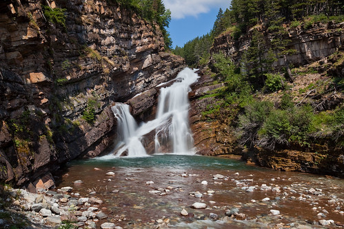
Have I mentioned the waterfalls? ;-) St. Mary, Virginia, Grinnell, Running Eagle, Bird Woman, Haystack, Twin, Rainbow and Ptarmigan all got a shout-out in the diary, but there are even more! Swiftcurrent, Apikuni, Baring, Florence, McDonald and Redrock Falls on the American side of the border, Crypt, Cameron, Blakiston, Hell Roaring and Bertha Falls on the Canadian side just to name a few.
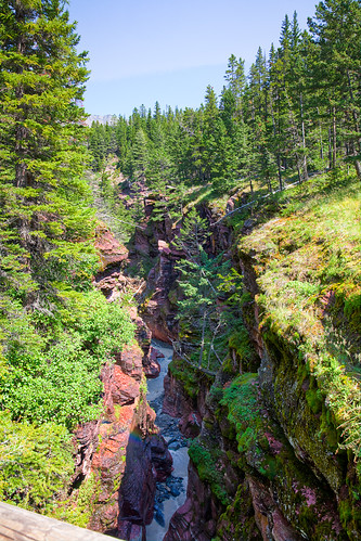
|
Red Rock Canyon in Waterton Lakes. Upon exiting the canyon, the creek later falls over Blakiston Falls.
|
|
|
Cameron Falls in the Waterton Townsite. Waterton may be a bit touristy, but offers some beautiful views such as this and those along the lakeshore. It is virtually a ghost town in winter as the snows and extremely high winds prevail. As the T-Shirt in one of the shops says, in winter it becomes a "drinking town with a bear watching problem."
|
Some Waterton Notes
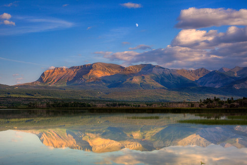
|
The moon over Sofa Mountain at Maskinonge Lake just outside the pay station entrance of Waterton Lakes National Park.
|
If you are going to Glacier, I'd definitely give strong consideration to making the trip into Canada to Waterton Lakes. The drive itself offers some stunning views, the Prince of Wales Hotel, designed in the swiss chalet style is a sight to behold and the town has a very nice vibe to it even if it a bit touristy. There are several nice galleries and good shopping, but the sights are what you come for. Visit the Red Rock Canyon and Red Rock Parkway. Take the Akimina Parkway to Cameron Lake. Take a drive through the bison paddocks to see the creatures that once blanketed the great plains of the U.S. and Canada. Take the boat tour on the
MV International. It is worth the hassle of crossing the border. I'm sure the Canadian crossing guards ask everybody twice with very suspicious looks on their faces if they have any guns and that it wasn't just because we were from Texas.
Conclusion
This only scratches the surface of these two parks, but should provide a nice foundation to build from for anyone planning a trip to either or both of these parks. It is a wonderful and wonderous place and can highly, highly recommend it...especially before all the glaciers melt.
(photo credits: image of Glacier Park Lodge lobby by Bruce Fulton, McDonald Lodge by Steve Cyr, Sperry Chalet by Rachel Zinger and Running Eagle Falls by Brett Vogel are republished in accordance with the terms and conditions of the Creative Commons license under which they were published. All other images are copyrighted by republished by moi.)