It's time to continue our ongoing series Eldfjallavakt, where we've been covering the serious situation going on under Iceland's largest volcano, Bárðarbunga.
Except that increasingly, "under Bárðarbunga“ is a poor description. Because now the magma intrusion that she's sent forth at an average rate of hundreds of cubic meters per second (similar to the flow rate of the Hudson River at New York City, straight through solid rock) has gone over 30 kilometers from Bárðarbunga's magma chamber, its end is no longer under the glacier Dyngjujökull, and it's now heading straight toward the magma chamber of Askja, another large, dangerous volcano in the highlands.
What does this mean? Join us below the fold.
--------
Pronunciation guide:
Bárðarbunga: BOWR-dthar-Boon-ka
Dyngjujökull: DING-yih-YUH-kih-tl
Krafla: CROP-lah
Askja: AWSK-yah
Austfirðir: OYST-fear-dthear
Jökulhlaup: YUH-kihl-HLOYP
R is an alveolar trill if slow, an alveolar tap if fast; ð is an voiced th (rendered dth), like in "this", not "thin"; ll (rendered as tl) is a tongue click where you let the pressure build up behind your tongue then spill out to the sides; g (rendered as k) is devoiced like a k but unaspirated like a g; n is generally devoiced; and there's probably other clarification I should make, but that's good enough. :)
--------
Spring, 1875. Austfirðir (the Eastfjörds). Quakes had been felt late last year, but nothing had happened. There were no active volcanoes in the area, so there was nothing to be concerned about - or so was assumed. Had people walked a hundred miles into the highlands, they would have learned that a small eruption had started at the little known volcano Askja in January, but the area was sparsely populated.
However, on the 28th of March, all hell broke loose as Askja switched to a major Plinian eruption so powerful that her remoteness ceased to be sufficient. A fearsome plume rose above the Eastfjörds, all the way to the sea. Then came the pumice rain, while lightning crackled intensely. Hot chunks the size of tennis balls rained down across a vast area. A suffocating ash descended so thick that people could barely see their own hands. The eruption continued for a year at lower intensity.
The ash falls and pumice killed few people directly but led to the loss of large amounts of livestock. This, plus fear of further eruptions, caused widespread abandonment of towns in the Eastfjörds. A large chunk gave up on Iceland outright and moved to Manitoba and the northern US, forming towns such as Gimli, Manitoba. These people are now known in Iceland as the “vestur-íslendingar" (Western-Icelanders).
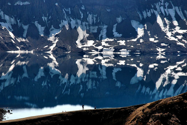
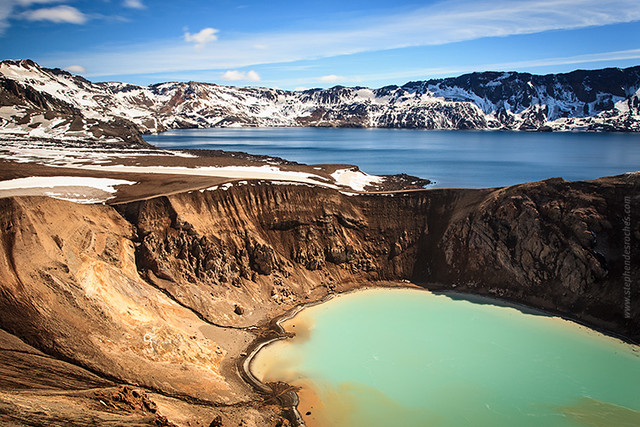
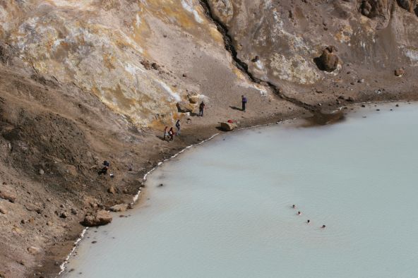
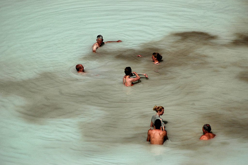
Today, Askja (whose name now means caldera, and is similar to the word for ash, "aska") is a popular tourist spot, where people come to see the massive caldera (easily visible from space) looking like a bullethole in Iceland, and to swim in the warm waters of a side section called Víti ("Hell"). But she's still highly dangerous, even when not erupting.
In 1907, two German scientists, Walter von Knebel and Max Rudloff, were investigating Askja in a boat... and neither they nor their boat was ever seen again, despite a major expedition launched by von Knebel's fiancee. Many theories over the ages surfaced, such as the prospect of a CO2 surge suffocating them, or even simple accidental drowning. However, just weeks before Bárðarbunga, the most likely cause made itself abundantly clear:
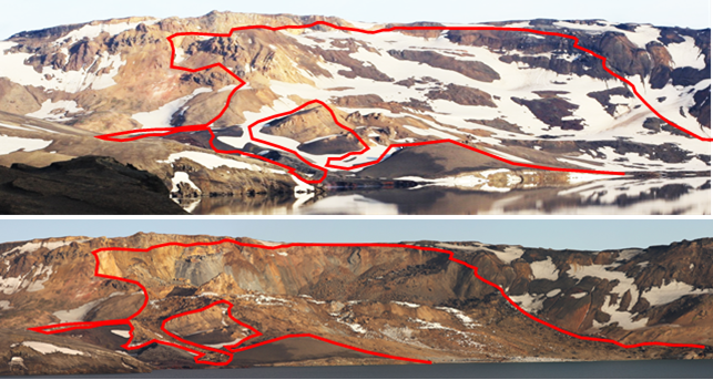
Around midnight, a large chunk of a side of the crater collapsed down into the caldera. Slamming into the water, it launched a 50 meter tidal wave ringing around the caldera, including into Víti. Had it not happened at midnight, the death toll would have been significant. This has now become the leading theory as to the cause of death of the scientists. The steep, unstable sides are triggered by the continual sinking of the core of the caldera
This raises a question:
Why the heck are we talking about Askja?
Because Bárðarbunga's magma intrusion is well on its way to linking the two magma chambers together:
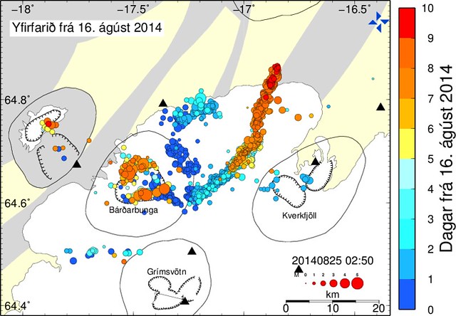
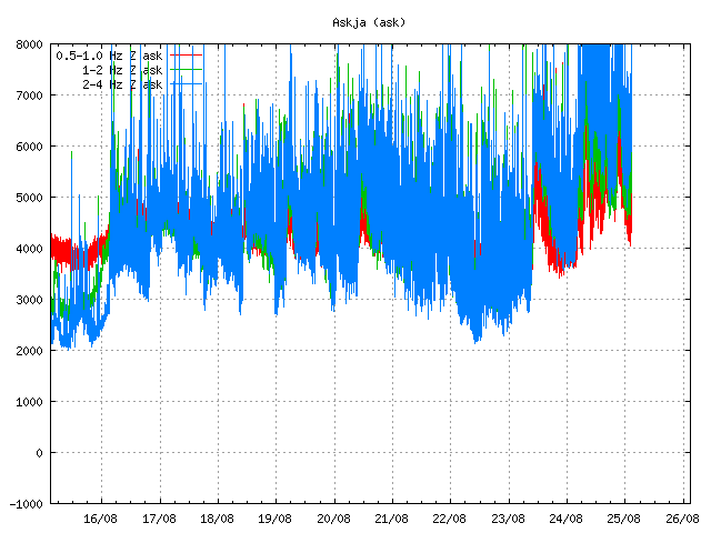
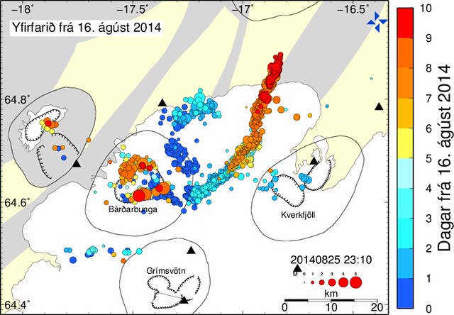
Activity continues at a incredible rate, due to what is being described as a "ridiculous amount of magma" rapidly flows to the northeast and north:
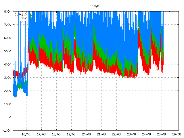
Two explanations have been put forth for why the already record level of activity rose so dramatically - one involves the magma breaking through colder rock, while the other involves a great increase in the magma flow. Regardless, surface tremors (often a key indicator of an eruption or imminent eruption) are up and regularly spiking at the meter nearest Bárðarbunga's caldera:
But you know where they're up even more? Askja:
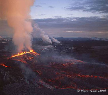
So, where is all of this going? Páll Einarsson, a professor of Geophysics, presents a happy possibility. According to him, the presence of a long dike leading out from the caldera at 5-10 kilometers depth reminds him of the Kröflueldar ("Krafla Fires") (in Icelandic, lava fountain eruptions are often referred to as "fires"). Krafla erupted for nearly a decade, but at a slow rate, involving many subterranean magma intrusions. Consequently, the lava flows and gas emissions remained at levels that were not too dangerous - a "tourist eruption".
Haraldur Sigurðsson, another volcano expert, argues (using some of the same arguments as Páll) that it's wrong to think of these volcanoes that lie directly on the major rifts as distinct systems, that they usually stretch out over many dozens of kilometers or more. Examples include the connected eruptions of Katla and Eldgjá (Laki) in 970 (connected by a 55km dike) and the eruptions of Eldgjá (Laki) and Grímsvötn in 1783/4 (connected by a 70km dike). Askja, too, had a paired eruption with Sveinagjá in 1875. In all such cases, the lava that comes out of the systems is identical.
He raises the question, why don't we ever see quakes deeper than around 15km? The answer is simply, the rock there is too soft and breaks too easily for us to measure it. But there is no reason to believe that magma isn't flowing there either. Basically, that this shouldn't be viewed so much a magma intrusion / conduit, but a complete break in the crust (except at the surface). The surface expressions are just where the magma finds it easiest to break out, whether just through a single point, or through hundreds as in the case of a major rift eruption.
The exact nature of what will happen (since there's so many types and magnitudes of eruptions here) depends, according to him, on whether the rift cuts through Askja's magma chamber or goes around it. Regardless, he points out that the most likely point for magma to reach the surface is in the lowlands. Now that it has moved out from under the ice of Dyngjujökull, it's entered an area that should be easier to facilitate an eruption.
Lots of people have been commenting on the different types of eruptions we could expect, and honestly I'm not sure what to believe. However, I don't see in the historical record any evidence of anything that resembles the Krafla Fires in the Bárðarbunga area, so my intuition tells me that may be too optimistic. But one can hope. :) And even if it simply begins slow but changes form later, any letting off of pressure in a controlled manner would be a good thing.
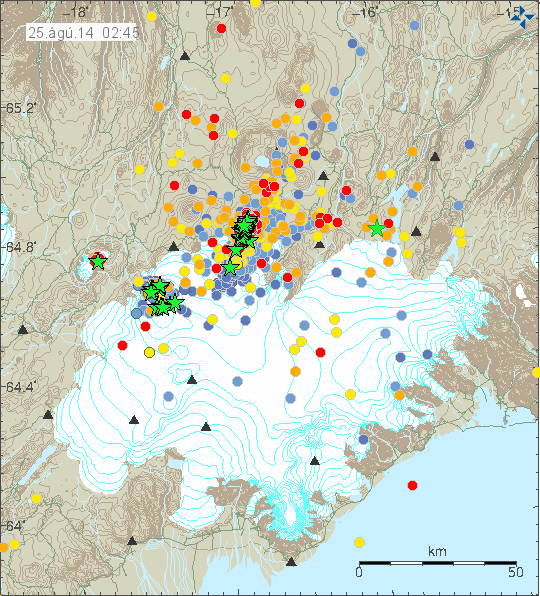
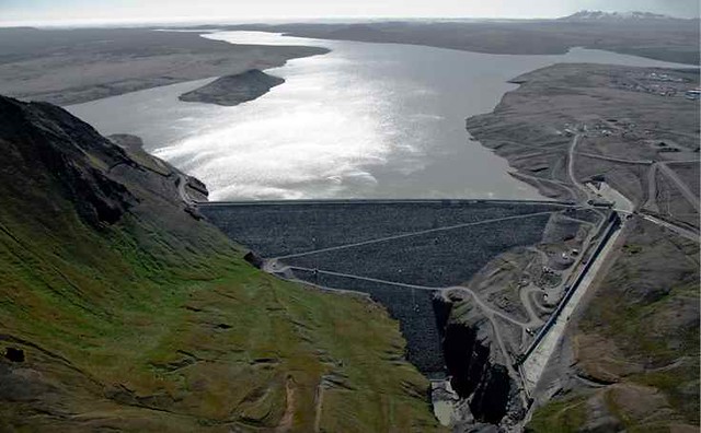
As a final observation: we're starting to get even major earthquakes in side areas as well: under Tungnafellsjökull and right near Hágöngulón, the reservoir for the largest dam of its type in Europe, and there's lots of activity between there and the main magma conduit. While at this point there's considered no likelyhood of a jökulhlaup heading into the reservoir, they're not taking any risks; they'd already started draining down the reservoir. It's nice to see such precautionary measures taken even when a probability is low.
Update, 11:00 25 august: In an article on Visir.is, Sara Barsotti, a volcano expert for the Met Office, says she finds it unlikely that this event is going to end without an eruption - but whether that happens in the next hours, days, or even weeks or months is the question. She disagrees with Haraldur that it's likelier for the eruption to come up in the glacier-free area between Dyngujökull and Askja - she feels that that makes no difference.
In a different article, professor Magnús Tumi Guðmundsson states that a theory for the tremors and sudden rise in quake activity that led to the false alarm about a subglacial eruption is that the magma encountered a pocket of groundwater, which would (naturally) resemble the effects of hitting the glacier. He notes that this is just a theory and has not been proven.
Honestly, that sounds bad to me because the last thing I want in this magma is more dissolved gasses and pressure. :Þ
Minor update, 2:00: The magma intrusion is now said to be 35 kilometers long and contain 300 million cubic meters.
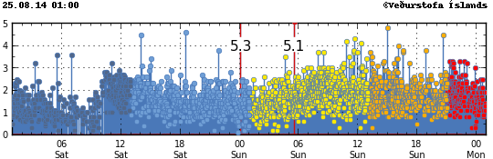
Update, 11:15: Rather than do a new diary this evening since the current status is continuing, I'm going to do an update instead. Earthquake activity is still bonkers:
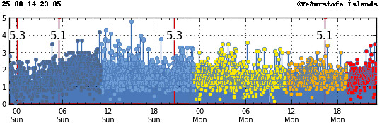
Yes, that's four quakes over magnitude 5 in two days. We normally get a mag 5+ quake once every few years. The intrusion is now 6-7 kilometers north of the glacier and well on its way to a possible intersection with Askja:
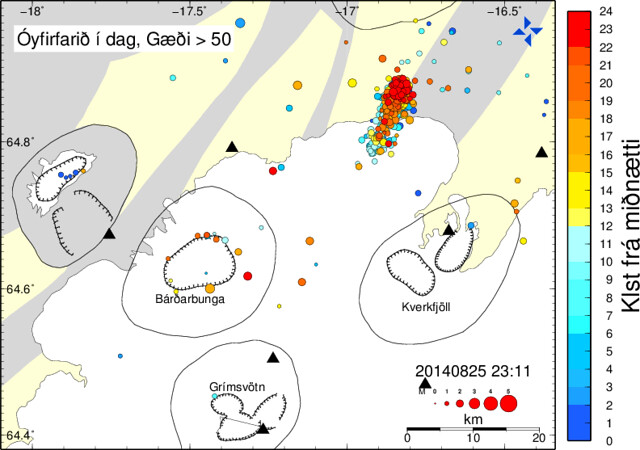
Here's the activity just for today:
Volcano experts interviewed in the Icelandic press continued to be mixed on this. One update from the previously mentioned Haraldur Sigurðsson: he thinks it's probably going not to erupt because the intrusion seems to be getting deeper, but warns of the consequences of a possible intersection with Askja's caldera:
It's possible that this intrusion now could get into the magma chamber in Askja and it's a serious problem. The magma chamber uner Askja could contain acidic magma, that is to say rhyolitic (high silica) magma, like came up in the eruption of 1875. It was one of the most powerful explosive eruptions that have occurred in Iceland. And we know that when magma enters the magma chamber of acidic magma, like happened in 1875, then there's an explosive eruption," says Haraldur
He discusses how the Askja eruption in 1875 had an ash fall so great that settlements were abandoned across the Eastfjords, and that the eruption is considered to have set in motion the migration to the New World.
Due to the magma moving out from under the glacier and thus decreasing the odds of a jökulhlaup, as well as the confirmation of the false alarm of the eruption, the road on the
eastern side of Dettifoss has been reopened, and camping has again been allowed in Ásbyrgi. The western road and trails, however, are considered too dangerous to reopen despite the reduced flood risk. Return traffic is reported to be light.
Tour companies are reluctantly accepting the damage to their businesses. They point out that if it does erupt they obviously can't go there for a long time, but if it doesn't erupt, then the area is going to continue to be closed as a precaution. And it's not simple just to redirect tourists to other places. "If you plan to go up the Eiffel Tower and it's closed, then you don't go to some other shop instead. Askja is Askja an people have come to see her. Most tourists come in rental cars but need us to get them to places where the cars can't make it. If Askja is closed, then they simply will go to places that they can get to in their cars.", says one tour operator.
