"The worst flooding Cedar Rapids has ever seen." That's how the morning talk show host on 600 WMT-AM just described the devastation. Make no mistake - this is a flood of epic proportions. Nothing like this has been seen in Eastern Iowa in recorded history.
To give some perspective on just how bad it is, here are the river crests for the previous big floods:
Previous record flood in 1929: 20 feet
The Flood of 1993: 19.3 feet
Current river level in downtown Cedar Rapids: ~30 feet and still rising
UPDATE at the bottom with more information for Des Moines, Iowa City, and Cedar Rapids, as well as a couple of donation options.
Please forgive me if I recall some inaccurate details from 1993. I was 13 at the time, so I'm recalling through that lens.
This is how the headline of the Cedar Rapids Gazette Online reads this morning:
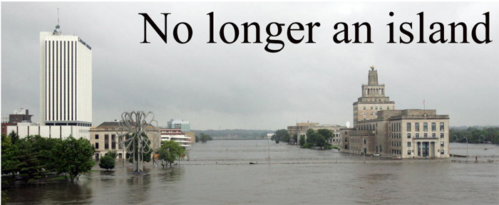
Cedar Rapids is one of only 2 cities in the world with its City Hall built on a free-standing island in the river. Mays Island sits right in the middle of the river and houses City Hall, Federal Courthouse and the County Jail. In 1993, Cedar Rapids had major problems with water in the lower levels of the Veterans Memorial Building (that's what City Hall is called) but water never reached the structure proper.
If you're following any of the local/regional coverage of the disaster, you may hear the terms "100 year plan" or "500 year plan" or some derivative thereof being mentioned. Here's what those terms mean: that's the likelihood that a disaster of this magnitude will take place in a given year. So, the city is currently executing past its 500 year plan, which means there's a 1 in 500 chance of this flood happening in a year.
Here's the evacuation area for the 500 year plan (these are images - I can't embed the Google Map. If you want to play around with the map, click here to go to the KCRG website):
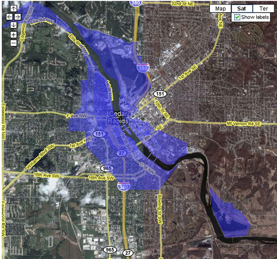
Please note if you're in the local area that the 500 year flood plan evaucation area is now being expanded beyond the old maps. There are several areas of downtown Cedar Rapids that are outside the 500 year plan that are now closed and evacuations are mandatory!
On this map, the flooding in 1993 reached approximately to the low-lying areas between First and Second streets.
Here's an overhead view of the Mercy Medical Center complex in Cedar Rapids. I've circled the hospital in red, and marked the approximate new evacuation/flooding area. This area is now completely under water:
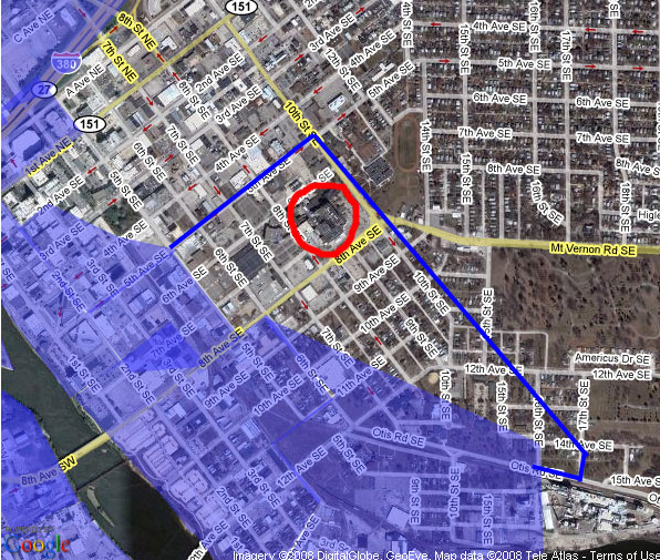
They started sandbagging the interior of Mercy's lower levels at about 8:30 last night, and evacuation of the facility about 11:00pm CT. Critical Care patients have been taken to St. Lukes Hospital, as well as several other facilities in the region - Allen Memorial in Waterloo, Dubuque Regional in Dubuque, as well as many others. If you're a local and you have family members that were evacuated from Mercy Medical Center, you can call the Mercy Pastoral Care Hotline at 319-398-6106 to check on the status/location of your family members.
IMPORTANT: If you're local, St. Lukes Hospital is still accepting patients and still has Emergency Room care available. The hospital is currently not in any imminent danger of flooding.
Last night, as soon as the news was broadcast across the TV that Mercy Medical Center was in imminent danger of flooding, literally hundreds of people made the trek downtown to help sandbag. The volunteerism of Eastern Iowans never ceases to amaze me. The city of Cedar Rapids has been asking for volunteers since Tuesday, and have had to ask several times that volunteers stop coming to particular locations because they were completely overwhelmed with people.
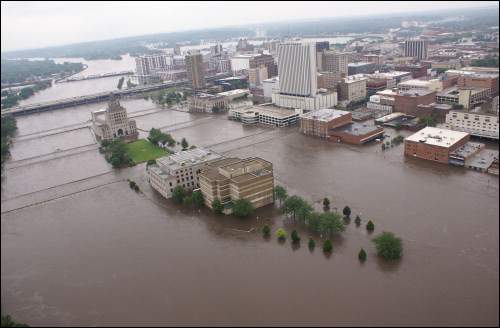
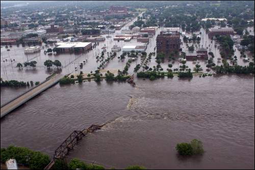
Here's another view of Mays Island where City Hall sits:
This CRANDIC rail bridge that connects Penford Products to the rail network collapsed yesterday morning. They parked box cars on the bridge and filled them with gravel to try to keep the bridge from lifting off its piers and floating away, but the stress was too much for the structure.
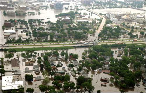
Note that in the following pictures, most of the homes and businesses in these areas do not have flood insurance. The water never reached this far into the city on either side of the road during the previous floods. No one anticipated the reach of this disaster
This is Cedar Rapids, just North of the Quaker Oats plant, east of the river.
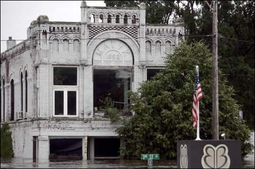
3rd Street in Cedar Rapids. This street is part of the historic Czech Village neighborhood in Cedar Rapids...we're about 1/4 mile from the river here. Notice the 3rd Street sign in the lower center of the picture. The block in the middle is a sign out front of the funeral home.
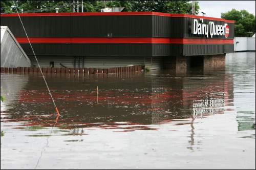
This is the Dairy Queen on First Avenue near City Hall. We're about a block from the river. Please note that during 1993 the water did not reach past this structure.
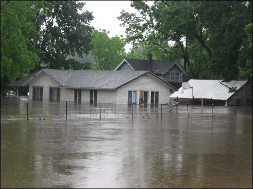
Here are some homes along Ellis Road, one of the lowest areas in town. The Ellis Road area was the first to be evacuated on Tuesday as the waters rose.
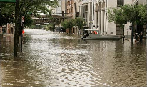
Here's a picture of Second Avenue in downtown Cedar Rapids. I'm trying to guess from the pictures, but I think this is the corner of 2nd Avenue and 4th Street on the map above.
This is the sandbagging effort at Greene Square Park yesterday (3rd Avenue and 5th Street above.) This area is now potentially underwater.

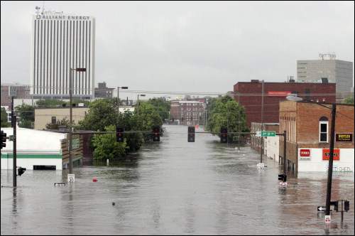
This is a picture of 3rd Avenue looking east. The big, white building in the picture is the headquarters of Alliant Energy. They're currently working without the ability to access their headquarters. I can't really read the street sign, but I think that's 3rd Street S.E.
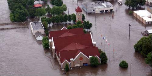
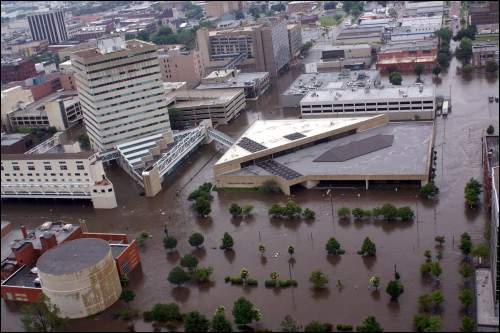
Here's a picture of the National Czech and Slovak Museum in the Czech Village neighborhood of Cedar Rapids. This makes my heart hurt. There are many priceless and irreplaceable documents and artifacts in this museum. They went to work on Tuesday building an earthen dike around the facility, but the flood waters completely ovewhelmed it. The water is higher than anyone thought it could be.
The building with the triangle roof in this picture is the Cedar Rapids Public Library main branch. The water threatened the library in 1993, but it was never threatened of this magnitude. The water is past the first floor of the library and is now infiltrating the second.
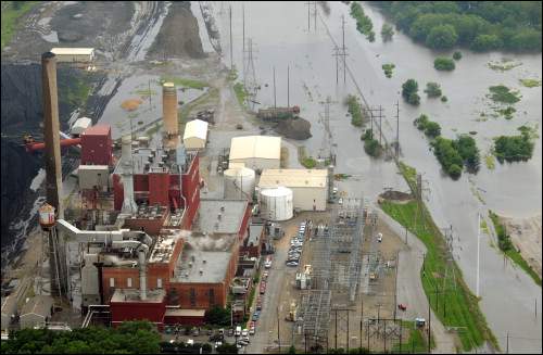
Here's the Prairie Creek Power Station. I was consulting with some family that works for Alliant Energy, and they tell me that if this plant goes out due to flooding, there's a good chance that most of southern Cedar Rapids, Mt. Vernon, Lisbon, and several towns to the East of Cedar Rapids could be without power for several days.
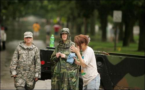
The National Guard is all over Eastern Iowa helping out. Thank God for these men and women.
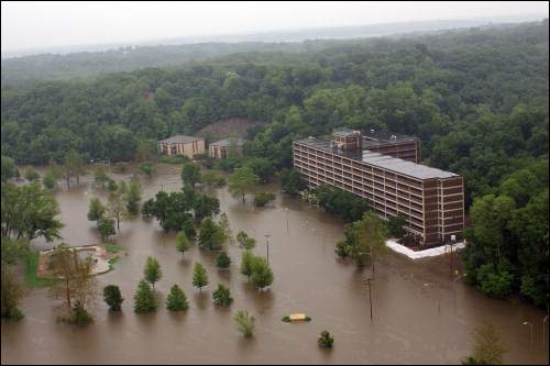
Here are a couple pictures from Iowa City:
The Mayflower Residence Hall at the University of Iowa.
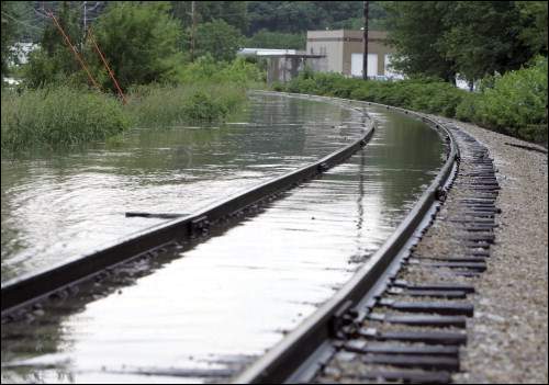
The CRANDIC railroad line off Highway 6 (the Coralville Strip) in Coralville. The dike that this railroad line runs on was breached yesterday night about 9:30pm and water is now flowing through the breach and onto Highway 6. This area (around the Heartland Inn, south of Coral Ridge Mall) is now impassable.
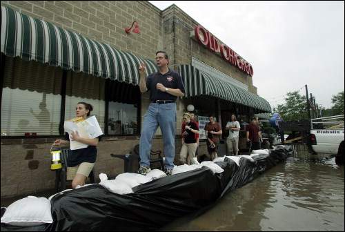
This is the Old Chicago Restaurant on Highway 6 in Coralville. They thought they might save the restaurant, but with the CRANDIC dike breach, it will be underwater if it isn't already.
Please keep Eastern Iowa in your thoughts and prayers. I'll post an action diary soon for those wanting to help financially or through volunteerism.
Personal note: I, personally, am safe. I live in Lisbon, which is about 18 miles to the East of Cedar Rapids.
IMPORTANT INFORMATION regarding the Cedar Rapids water supply
The city of Cedar Rapids only has one functioning well at this point. The other 3 are under water. A large sandbagging effort was taking place last night, and managed to save the last well.
As such, the city's water supply is currently running at 25% capacity. If you live in the Cedar Rapids Metro Area (Cedar Rapids, Hiawatha, Robins, etc.) please conserve water!
The water is currently potable - you can drink city-supplied water at this point, but they're asking that you curtail all non-vital water-related activities.
The Cedar Rapids Public Works Department is asking that you only use water for drinking. Please delay all other activities until the city is able to increase capacity. They are trying to reduce usage by 4 million gallons per day, and if that does not take place, rolling water outages may be necessary in order to preserve system pressure and potability of water.
The city asks that you:
- Use paper plates, silverware, cups, etc. when possible so you don't have to wash dishes
- Use the "if it's yellow, it's mellow - if it's brown, flush it down" rule. Please don't flush your toilets unless absolutely necessary.
- Please cease all water-related activities that are not absolutely necessary (washing dishes, bathing, flushing toilets, washing cars, watering lawns...)
The Linn County Democrats just sent out this email:
If you NEED HELP, call the United Way's hotline at 211. If you need shelter, Prairie High School still has openings. (There is no further space available at Viola Gibson.)
If you can volunteer in Cedar Rapids, please call the City of Cedar Rapids Volunteer line at (319) 739-4211. If you can volunteer in other areas of Linn County, please call the Linn County Volunteer line at 866-469-2211.
Other contact agencies are the Red Cross (319) 393-3500 or the Salvation Army (319) 364-9131 to check if there is a need for food, clothing or other items.
Please post additional contact info/action items in the comments below. I'll add them to the diary as I can.
Note: There are several smaller communities in Eastern Iowa that are affected by this flooding that I haven't chronicled here, such as Palo, Vinton, etc. Please keep these folks in your thoughts and prayers as well.
UPDATE: (thanks to the Daily Kos tech crew for fixing my edit abilities for me!)
VERY IMPORTANT INFORMATION FOR IOWA CITY RESIDENTS
The city of Iowa City is now announcing mandatory evacuations for all residents in the Iowa City 500 Year flood plan. Please click this link to find out if you're in this area.
Here's another link [PDF] to the entire map.
If you are, and you're reading from any place other than home, GO HOME NOW! Pack up important documents such as birth certificates, documents relating to your home, and any valuables that you can carry and prepare to leave immediately!
The Iowa River at Iowa City is forecast to rise another 5 feet between now and Monday! The Highway 6 dike has been breached, and the dike that separates Coralville Reservoir from Lake McBride has also been breached at this time.
VERY IMPORTANT INFORMATION FOR DES MOINES RESIDENTS
The City of Des Moines is now ordering a voluntary evacuation of the downtown regions of Des Moines, and also evacuating according to their 500 year flood plan.
Click here to see if you're in the 500 year evacuation area.
City officials are saying that the water may have peaked in Des Moines, but the dike system in the city is extraordinarily taxed right now. Failures are not imminent, but they are expected, and they're warning people to stay out of the low-lying areas of the city.
For those wishing to help out, here is the information I've found so far. (h/t to peraspera in the comments.)
If you donate to the local Red Cross chapter instead of the national Red Cross more of the money goes to the affected areas. This is the donation page info (under the FAQ link) from the American Red Cross Grant Wood Area Chapter which serves the Cedar Rapids area.
You can donate to the American Red Cross Grant Wood Area Chapter online. To make your secure MasterCard or Visa donation, please click here.
You may also donate by phone or mail.
To make a gift on your credit card via phone, please call (319) 393-3500.
Mail a check or money order to:
American Red Cross Grant Wood Area Chapter
PO Box 10375
Cedar Rapids, IA 52410-0375
The Red Cross (ARC of East Central Iowa) is bearing the brunt of providing shelter and food for the displaced (estimated at this time to be approximately 25,000 in Cedar Rapids alone.) Please consider a donation if you can.
As pointed out by oldjohnbrown in the comments, the Salvation Army has been supplying food, water, and miscellaneous supplies to the volunteers around the city. Please consider visiting their page here.
The Iowa DNR is now reporting that the river has crested in Cedar Rapids - 31.02 feet and is now receding! Hopefully, if we don't get any more rain, it'll start to recede in a meaningful way.
KCRG TV9 News is now reporting that the DNR does not expect the river to return to 1993 flood levels until Wednesday, June 18th. They do not expect the river out of "major flood stage" of 16 feet until Friday, June 20th. They do not expect the river to go below flood stage again (12.4 feet) until Sunday, June 29th. No linky yet...it came across the TeeVee a little bit ago. We have a long, muddy slog ahead.
For more Iowa City pictures, please visit oldjohnbrown's comment here and click on his links.
I'll keep updating as more information becomes available.
Also note...as the situation in Iowa City deteriorates, I will be posting other diaries in the coming days with information and updates on the situation there.
