I live in Woodland, California, approximately 25 miles northeast of Sacramento in California's Central Valley. As I type this text, I can hear the rain falling on day 4 of the "pineapple express" storm currently hitting the west coast. While it is unlikely that this storm will produce extensive flooding, it is a reminder that I live in a region that has experienced enormous floods. A diary by A Siegel highlighted the results of a recent study about the potential for megastorms to overwhelm California's flood control systems, which could lead to extensive loss of life and property. While I can't say I know very much about that particular study, A Siegel's expression of concern for the well-being for those of us living here is much appreciated! In additon, his diary was my inspiration for writing this diary, to share what I know about the flood protection system here in my corner of the world.
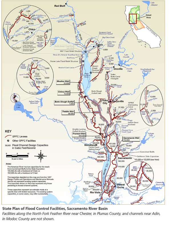 Source: California Department of Water Resources State Plan of Flood Control Descriptive Document
The reality of past floods on the Sacramento River and its tributaries lead to the creation, over many decades, of the Sacramento Valley Flood Protection System, part of the State Plan of Flood Control. I borrowed the figure above from the California Department of Water Resources (DWR) webesite. The title of this diary comes from Robert Kelley's "Battling the Inland Sea: Floods, Public Policy, and the Sacramento Valley," a fascinating telling of history of the construction of this system. This book, along with information from DWR and my understanding of this system based on living in the middle of it, are the sources for the information presented herein.
There are three physical components of the Sacramento Flood Protection System:
- Dams and the reservoirs behind them
- Levees along the various water courses
- Bypasses
A fourth non-physical component is flood fighting, the sometimes heroic efforts taken to prevent a levee or other failure during a high water event. I've talked to people who have worked on sandbagging and/or covering levees in the middle of rain storms, likely preventing their neighbors from getting wet or worse. While flood fighting can be essential, the rest of this diary will focus on the three components listed above.
Dams and Reservoirs
There are five large dams and reservoirs in the system: Shasta on the main stem of the Sacramento River (north of the area shown on the figure above), Black Butte on Stony Creek, Oroville on the Feather River, New Bullards Bar on the Yuba River, and Folsom on the American River. Each of these dams is managed to control the volume of water that is released into the lower stretches of rivers, the areas which also happen to be where the most people and property (i.e., homes, businesses, orchards and the like) are located: the large cities of Sacramento, West Sacramento, Woodland, Davis, Yuba City, Marysville, and Chico along with dozens of smaller communities.
At the beginning of the wet season (generally about now), all of the reservoirs are typically at their lowest level for the year because the reserves get used up for agriculture, residential, and commercial purposes over the long dry summers. Because the current storm is hitting when the reservoirs are low, much of the runoff from higher elevations will be captured in the reservoirs, preventing widespread flooding for us low-landers. The primary flood threat from the current storm is from smaller creeks and interior drainage.
If additional storms start to stack up, the reservoirs will be used to regulate the overall flow into the system, sometimes leading to very large volumes of water released into the rivers below the reservoirs. The dam operators continuously monitor the inflow into their reservoirs, balancing these expected volumes with their releases. They have to be careful to keep the reservoir level low enough to recieve inflows without leading to overtopping of the dam - as far as I know, none of these large dams were designed to handle overtopping without potential for catastrophic failure. Many of the smaller upstream dams can and do allow overtopping but the big ones do not (if someone knows otherwise, please let me know).
When the releases from the reservoirs, along with continued rainfall on the valley floor, create very high volumes in the rivers themselves, the next line of defense against floods is the levees.
Levees
The red lines on the figure above are levees in the State Plan of Flood Control System (levees that are operated under State and federal requirements; there are a very few small non-SPFC levees in the Sacramento Valley that are owned, operated, maintained, and funded solely by small communities - I know they exist but I don't know much more about them).
Constructed levees are, in a basic sense, piles of soil placed between a river and the communities that are in the river's floodplain. The earliest levees were constructed by dredging material from the riverbed and/or adjacent land with little regard for the physical properties of the material used, or how it was placed. Some of the levees in the valley retain these non-engineered properties although most have, to some degree, been upgraded to better match the current understanding of how best to construct levees. The geometry and geotechnical requirements for Sacramento levees aredefined in a 1953 Memorandum of Understanding Respecting the Sacramento River Flood Control Project and various US Army Corps of Engineers documents (see discussion here; I could not find the MOU on-line MOU is here [h/t gtaylor in the comments]).
The levees in the Sacramento Valley are as much as 25-30 feet higher than the immediately adjacent land. On more than one occasion, I have found myself driving along a levee road where the water level in the river was higher than than the landside homes' first floors - an eerie sight, no doubt.
As is apparent in the figure above, there are places along the Sacramento River where the two levees on opposite sides of the river are very close together, so close that the blue line of the river is not visible at the scale of the map (e.g., for most of the length of the Sacramento River between the Butte Slough Outfall and Fremont Weir). According to Robert Kelley, this configuration is the result of an early engineering hypothesis that, in a narrow river channel, the increased flow velocity would scour the bottom of the river channel deeply enough to contain the entire flood flow in the channel. It took several decades and more awful floods for the engineering community to be convinced that these narrow channels could never contain the full volume of the largest floods. This realization lead to the creation of the bypasses to help funnel floodwaters away from communities.
Bypasses
In the figure above, the lighter blue patches represent the bypass system, beginning with the Butte Overflow Basin (Butte Sink), down through the Sutter Bypass, crossing the Sacramento River at the Fremont Weir, and down through the Yolo Bypass. The bypasses carry - by a considerable margin - the bulk of the flood volume through the Sacramento Valley, down to the Delta at Rio Vista, and from there, into the SanFrancisco Bay and then the Pacific Ocean through the Golden Gate. As shown on the figure, the capacity of the Yolo Bypass at its southern end is 490,000 cubic feet per second (cfs), whereas the capacity of the of the Sacamento River proper is only 110,000 cfs. That is a truly awesome volume of water. I've only seen the bypasses full on a few occasions but when it happens, the bypasses truly resemble an "inland sea."
The way the bypasses work is very simple - water overflows into the bypasses from the adjacent rivers and streams. Several creeks (Mud Creek, Butte Creek, Cherokee Canal) flow into the natural Butte Sink (see above). In addition, there are several weirs constructed on the bank of the Sacramento River north of the city of Colusa (not shown on the map but located at the north end of the Colusa Basin Drainage Canal) that overflow into the Butte Sink when the river level is high enough. From the Butte Sink, these overflow waters are funnelled into the Sutter Bypass. More water enters the Sutter Bypass from the Tisdale Bypass and the Feather River.
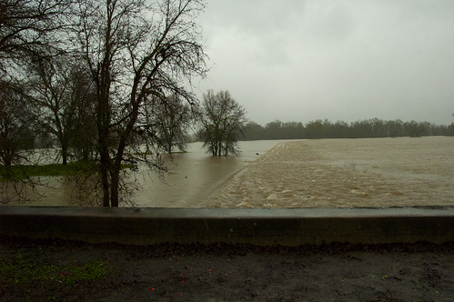
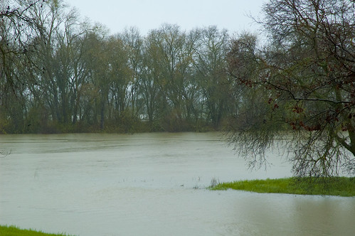
At the junction of the Sacramento River and the Sutter Bypass, the flow is split between the Sacrametno River channel and the Yolo Bypass. Below are some photos from this area that I took on March 19, 2011.
This first image is looking east from the south bank of the Sacramento River. The visible line is the Fremont Weir. Water is flowing to the right into the Yolo Bypass and into the Sacramento River channel (center of the photo through the trees).
This photo is from approximately the same location as the previous one, but looking north. The water in the foreground is the Sacramento River channel, flowing to the right (east). The water behind the trees is in the Sutter Bypass.
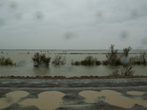
A bit further down stream, this photo was taken from a levee road looking west across the Yolo Bypass. The water level wasn't that high even though it looks like it is lapping almost onto the road. As I recall, there was at least 10 feet of freeboard, so capacity for a lot more water than we had that day.
Below the Fremont Weir, additional water enters the Yolo Bypass from Cache Creek, Putah Creek, and the Sacramento Weir to increase the volume by even more before the entire flow reaches the Delta.
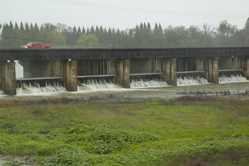
This is a view of the Sacamento Weir with the gates in place, leaky as they are. The gates of this weir are removed manually when the water level in the Sacramento River reaches a specified level. All of the other weirs are concrete structures with passive overflow.
The Future
The existing Sacramento Flood Protection System was built to handle floods of the magnitude that we understand them based on approximately 150 years of recorded history. Can this system handle a "megastorm" as hypothesized in the article referenced by A Siegel? Or the changing weather patterns expected as the climate warms? I don't know. It seems likely that some changes will be needed - management practices at least, new or upgraded infrasturcture likely. I do know that, with the funding allocated because of the passage Proposition 1E and Proposition 84, there is a lot of work underway to understand future flooding impacts and to begin taking steps to mitigate those impacts. Will the work be completed soon enough to avert the worst of the impacts? Will there be enough public support to invest in the necessary changes? We'll see. In the meantime, your concern for our well-being will continue to be appreciated.
