OK, this is about one of NorCal's favorite "back yards" - Yosemite, but also the trip there and back, a ramble to and into the Sierras and back. We left early Wednesday the 13th and returned late Friday the 15th. We went via Highway 140, 173 miles more or less, and returned via Highway 120, a different 166 miles, so there's a lot to report. Ergo, I'll just post the blurb and jump us past the orange bear scat to get going.
The Daily Bucket is a regular feature of the Backyard Science group. It is a place to note of any observations you have made of the world around you. Insects, weather, meteorites, climate, birds and/or flowers. All are worthy additions to the bucket. Please let us know what is going on around you in a comment. Include, as close as is comfortable for you, where you are located. Each note is a record that we can refer to in the future as we try to understand the patterns that are quietly unwinding around us.
|
The trip out
We pretty much ignored the scenery until we got into the foothills east of Merced on HWY 140. Some fall color, mostly yellows with some reds as we got past Cathey's Valley. There was a lof of pyracantha with ripe berries in this as area too. We eventually got to the part of the trip where we began to follow the Merced River, it was down, way down, and moving but not too rapidly. This is a whitewater river, people raft this puppy, but not currently. We hit Yosemite roughly this time of year most years, and this is the first trip in a loooong time when there was no rafting and no rafters. Some slide repairs and highway construction may have been a factor, but I really don't think the river would support rafting today.
Tioga pass is open. Really, Tioga pass is open.
Not too far past the park entrance, one gets a look at Bridal Veil falls, and it was running, but not really strongly or fiercely. Of course, we were distracted by all of the signs saying that Tioga pass was open. Tioga pass is
never open in mid November. Tioga, the pass to Lee Vining, Mono Lake and the rest of the high high desert, usually closes in early to mid October. It is usually the second week in October, but sometimes earlier, depending upon the snow. It is open - there ain't no snow. This is serious, as I will explain later, and I don't ski, so it isn't that.
Other matters
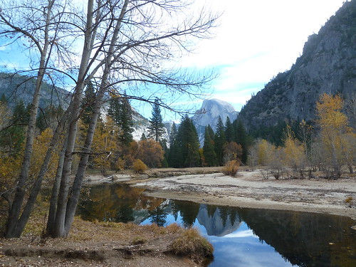
We saw a couple of decent herds of deer, single buck with plenty of does and juveniles. The bucks had all of their velvet on their antlers. The Merced River in the park was quite low but flowing. It was generally flowing so slow that one could take good pictures of things reflected in it:
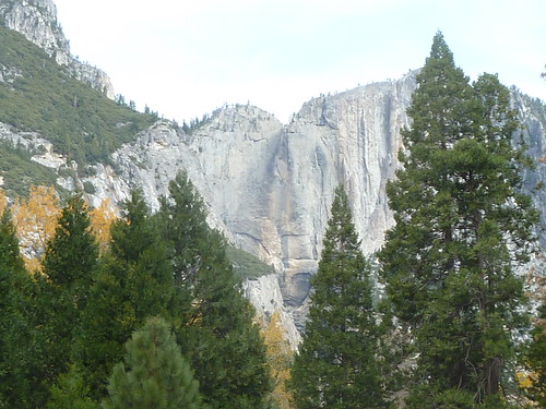
It got pretty cold, cold enough to rain or snow, if there were sufficient moisture in the air, but it was a dry cold. As far as we could see in all directions there was no snow, and not much water either. Yosemite falls was dry:
No bears or coyotes, but a goodly number and assortment of birds, mixed flocks of songbirds, Steller's Jays, White Headed Woodpeckers, Ravens and Acorn Woodpeckers. The various less famous falls weren't there.
Coming back
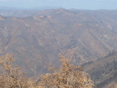
The trip back, along Highway 120 took us through and past old burns and eventually to the Ridge Fire area. Ghost forests covered by fire retardant, blackened trunks and dead needles. Outside the park we crossed over the South Fork of the Tuolumne River. There was a tiny puddle under the bridge. Next up was the Vista Point named
The Rim of the World Vista Point. As far as the eye could see it looked like nothing other than badlands writ huge; more like Borrego than South Dakota, because the latter does have some foliage and water. Nothing green or growing, no signs of life. Also, as far as the eye could see, no snow.
So, about that snow
I'll just make it short and sweet: Snowmelt provides 30% of California's water needs. This is already the driest year on record for CA and we would appear to have, as of 11/15/2013, no snow in Yosemite, none in Tioga Pass, and none looking toward Sonora Pass. This is not a good thing.
And on down the hill we go
The Fish Hatchery at the bottom of Old Priest's Grade had water. The outside bank of the grade had plentiful pyracantha with ripe berries. We crossed the main channel of the South Fork of the Tuolumne, a very large canyon of significant depth and width containing no water. Shortly thereafter we drove near Don Pedro Reservoir, which had water but was way down. The next serious watercourse was the Stanislaus River, a major tributary of the San Joaquin, which we crossed just west of Oakdale. It had some water visible from the bridge, but we could not tell if it was flowing or not. Much past that it is all diesels, cars, farms, stores and suchwhat, looking mostly like they always do.
**
"Green Diary Rescue" will be posted every Saturday at 1:00 pm Pacific Time on the Daily Kos front page. Be sure to recommend and comment in the diary.
**
Now It's Your Turn What have you noted happening in your area or travels? As usual post your observations as well as their general location in the comments.
Thank you.

