No doubt by now, you've heard the Science-Illiterates, proclaiming incredulously:
If There's Global Warming ... Why Is It So Cold?
link to video
yaleclimateforum -- Published on Jan 28, 2014
And no doubt, those same Climate clueless complainers, can't be bothered by watching a video or two, or reading the abstracts of a few Climate studies. So let me compile some 'study notes' for them in that regard ... you know for the next time our ever-morphing Climate System decides to give us another "Pop Quiz."
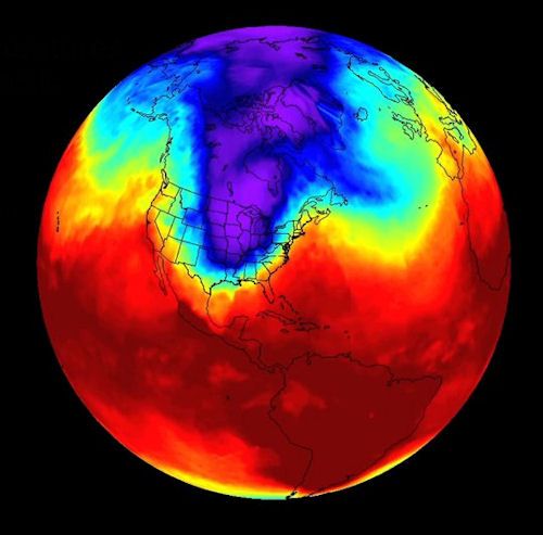
Here are few clips from the last video, attempting to answer the incredulous. First an image the "Polar Vortex" taking an extended "detour" -- sometimes called colloquially an "Arctic Express":
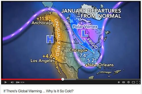
larger
Next a clip from the above video that shows the currently suspected "climate driver," that is sending the Polar Vortex off on its meandering way -- often technically referred to as "Arctic Amplification":
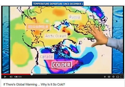
larger
Arctic Amplification:
The degree of warming observed in the Arctic is greater than that observed in the rest of the Northern Hemisphere -- a phenomenon known as Arctic amplification
Source: frontierscientists.com
Here's another colloquially way of putting it -- these interwoven phenomena, the Polar Vortex and Arctic Amplification:
Alaska in the 2013 Arctic turmoil
by Laura Nielsen, frontierscientists.com -- December 17th, 2013
Laura Nielsen for Frontier Scientists –-
“The Arctic is not like Vegas. What happens in the Arctic doesn’t stay in the Arctic. The major changes that we see in reduction in sea ice, reduction in spring snow cover extent, increasing vegetation that changes the radiation balance of the surface, potential changes in greenhouse gas fluxes, those are all …implications that extend beyond just the Arctic region to the rest of the world.”
Howard E. Epstein, environmental professor at the University of Virginia, was among the panel of researchers who presented the National Oceanic and Atmospheric Administration’s 2013 Arctic Report Card at the annual American Geophysical Union conference in San Francisco.
The NOAA Arctic Research Program releases the Arctic Report Card to summarize changing conditions in the Arctic, an increasingly important region in the world stage. One hundred forty-seven scientists from 14 countries contributed to this year’s peer-reviewed report.[...]
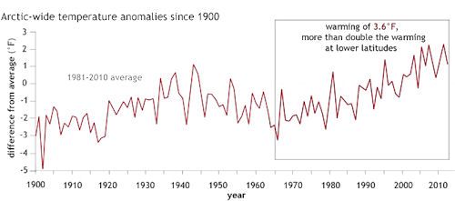
larger
See that box at the end of the trend-line in that last image, the one showing
the 3.6 °F. escalator-ride up in Arctic-wide temperatures over the recent decades?
That is "Arctic Amplification" -- that rising line (and also the "yellow areas" in the earlier image clips). It is about TWICE the equivalent temperature rises scientists have observed at lower latitudes over the same periods.
In other words the effects of Global Warming/Climate Change are occurring faster in the Arctic. The planetary climate changes (warming) are being "amplified" there, relatively speaking, to those of us who live elsewhere with more "moderated" changes occurring.
Occurring more frequently -- everywhere -- with each passing year.
Here is a more technical, Scientific summary of this trending 'hot topic' of "Arctic Amplification":
Vertical structure of recent Arctic warming
Nature 451, 53-56 (3 January 2008) | doi:10.1038/nature06502; Received 28 March 2007; Accepted 29 November 2007
Rune G. Graversen, Thorsten Mauritsen, Michael Tjernström, Erland Källén & Gunilla Svensson
Department of Meteorology, Stockholm University, S-106 91 Stockholm, Sweden
Near-surface warming in the Arctic has been almost twice as large as the global average over recent decades[1, 2, 3, 4, 5] -- a phenomenon that is known as the ‘Arctic amplification’. The underlying causes of this temperature amplification remain uncertain. The reduction in snow and ice cover that has occurred over recent decades[6, 7] may have played a role[5, 8]. Climate model experiments indicate that when global temperature rises, Arctic snow and ice cover retreats, causing excessive polar warming[9, 10, 11]. Reduction of the snow and ice cover causes albedo changes, and increased refreezing of sea ice during the cold season and decreases in sea-ice thickness both increase heat flux from the ocean to the atmosphere. Changes in oceanic and atmospheric circulation, as well as cloud cover, have also been proposed to cause Arctic temperature amplification[12, 13, 14, 15, 16, 17]. Here we examine the vertical structure of temperature change in the Arctic during the late twentieth century using reanalysis data. We find evidence for temperature amplification well above the surface. Snow and ice feedbacks cannot be the main cause of the warming aloft during the greater part of the year, because these feedbacks are expected to primarily affect temperatures in the lowermost part of the atmosphere, resulting in a pattern of warming that we only observe in spring. A significant proportion of the observed temperature amplification must therefore be explained by mechanisms that induce warming above the lowermost part of the atmosphere. [...] We conclude that changes in atmospheric heat transport may be an important cause of the recent Arctic temperature amplification.
Definition:
A more important process of atmospheric heat transfer is convection, which involves the mass movement of air (or any fluid) with its energy from one region to another.
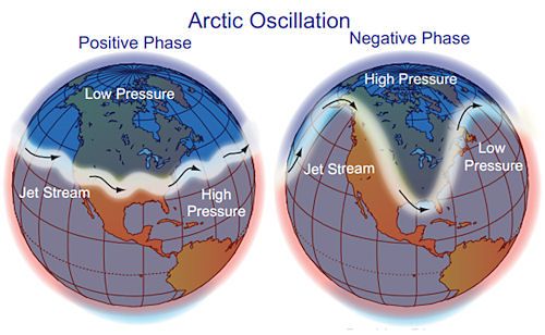
Kind of sounds like the basic old climate phenomena of
the movement of Air Masses, which warm
or cool other areas of the planet as these planetary-sized 'bubbles of air' pass on through. Perhaps even as the jet stream meanders very far northward, bringing the relative warmer air masses with it as pushes north.
Perhaps even as conversely, the supercooling-side of a Polar Vortex wave pushes its Air Mass southward somewhere else.
There’s growing evidence that global warming is driving crazy winters
by Chris Mooney, washingtonpost.com -- November 20, 2014
[...]
There's a nice video explanation of this by Francis here:
Jennifer Francis - Understanding the Jetstream (and Rossby Waves)
link to clip
Back in 2012, two researchers with a particular interest in the Arctic, Rutgers' Jennifer Francis and the University of Wisconsin-Madison's Stephen Vavrus, published a paper called "Evidence linking Arctic amplification to extreme weather in mid-latitudes." In it, they suggested that the fact that the Arctic is warming so rapidly is leading to an unexpected but profound effect on the weather where the vast majority of us live -- a change that, if their theory is correct, may have something to do with the extreme winter weather the U.S. has seen lately.
In their paper, Francis and Vavrus suggested that a rapidly warming Arctic should interfere with the jet stream, the river of air high above us that flows eastward around the northern hemisphere and brings with it our weather. Sometimes, the jet stream flows relatively directly from west to east; but other times, it takes long, wavy loops, as in the image above. And according to Francis and Vavrus, Arctic warming should make the jet stream more wavy and loopy on average -- some have called it “drunk” -- with dramatic weather consequences.
[...]
According to Francis, the extreme U.S. winter of last year and now, the extremes at the beginning of this season, fit her theory. "This winter looks a whole lot like last winter, it’s a very amplified jet stream pattern," she says. "We know that when we get these patterns, it tends to be very persistent. And it is definitely the type of pattern that we expect to see more often as the Arctic continues to warm so fast."
[...]
Say Hello to the new normal, mid-latitude snow-lovers!
Source: www.smithsonianmag.com
Why We Can Blame A Warm Arctic For This Winter’s Icy Chill
by Sarah Zielinski, smithsonian.com -- February 21, 2014
[...]
A weaker jet stream is probably more easily deflected off its path when it encounters something like a mountain range or a mass of hot air, Francis said. Those large waves increase the likelihood that a weather system -- such as a particularly cold winter or a period without rain -- gets blocked. “This means that the weather they create is lasting longer in your location. This leads to the more persistent weather patterns and the tendency of extreme weather of certain types to become more likely,” Francis said. “This is the hypothesis.”
[...]
But this appears to be a fairly new development in the evolution of the planet’s climate. The signal of Arctic amplification, first predicted back in 1896, really only became noticeable above the random ups and downs of the weather within the last 10 or 15 years, so its effects -- such as the weakened jet stream -- are just now starting to be experienced, Francis said.
And Francis admits that having weather pattern stuck in place by the jet stream doesn't explain all of the recent bouts of extreme weather. It will take scientists some time to figure it all out, but Francis noted that this hypothesis is backed up by a combination of observations, physics and climate models.
“There’s a lot going on in the climate system that affects the jet stream,” she said, “and figuring out how the different pieces of the puzzle fit together is a really active area of research right now.”
And finally back to that timely Washington Post
article -- for a closer look at this hot topic that is "trending" with Climate Scientists
[Arctic amplification as driver of the wandering Polar Vortex]:
[...]
Francis argues, however, that the evidence in her favor is mounting -- she cites no fewer than five (1, 2, 3, 4, 5) scientific papers published in the last year or so that she considers supportive, and hints that more are coming.
"We’ve got 5 papers that all look at that particular mechanism in different ways -- different analysis, different data sets, observation and models -- and they all come to the same conclusion and they all identify this mechanism independently," she says.
DecodedScience.com colloquially cites -- in plain English -- this
Arctic Amplification theory, and the recent extreme weather events that demonstrate its far-reaching mid-latitude impacts:
Climate Change, the Jet Stream and Wacky Weather
by Elizabeth Klusinske, decodedscience.com -- November 3, 2014
[...]
The combination of slower westerly winds and greater wave amplitude has led to a slowdown in the progression of polar jet stream waves eastward. This creates more extreme weather events since weather systems remain in place for longer periods of time.
The longer a weather system lingers, the greater the impact -- making events such as droughts, flooding, heat waves, and prolonged Arctic blasts more common. The study, Evidence linking Arctic amplification to extreme weather in mid-latitudes by Professor Jennifer Francis and Stephen Vavrus, cites the 2010 European and Russian heat waves, the 1993 Mississippi River floods, and freezing conditions in Florida during winter 2010–11 as examples of such events induced by an unusually slow moving jet stream. Observations show that the progression of the jet stream is especially sluggish in autumn and winter, when sea-ice loss in the Arctic is greatest.
[...]
I've
suspected such wide-ranging planetary phenomena for a while -- ever since I was banging nails into 2x4s (and sometimes missing --
OOOuch!!!) way back in the late 70's when
the -20 to -30 °F winter waves lasted for weeks on end. Abnormal mid-western winter weather, to say the least, even then.
Of course it takes more than suspicion to prove a cause-and-effect phenomena. It takes cold hard scientific study, and the analysis of the decades worth of data -- to discover the underlying "escalator-type" trends. To capture these ever-amping Climate-mechanisms in a scientific bottle.
These days, I've settled for simply watch those 'Polar Bubbles' bouncing around the planet, here and there exceeding its historical norms -- and then make plans accordingly in both clothes and travel (and retirement areas).
The planet's climate systems are indeed a fascinating thing to watch. It's almost like were trapped in some grand Terrarium -- and can't get out. And can't turn down the Thermostat either. I'm slowly coming to realize that the "trapped frogs" in that simmering/snow bound experiment -- sadly are turning out to be us.
larger
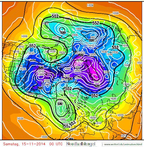
These days, I find the "Nordhalbkugel" setting (view from the northern axis) to be one of the more fascinating windows on this brave new, Terrarium world.
Please take time to enjoy the view ... In between shoveling the extreme-snow off the roof, of course. (The 'Nordamerika" animated vortex maps are occasionally informative too -- if you care about things like unusual, long-lasting "Arctic Blasts" that is.)

