(From the diaries -- Plutonium Page. Title edited for clarity. Also, click here to read about the relationship between global climate change and increasing hurricane strength.)
NOLA CHANNEL 4 UPDATES HERE. STREAMING VIDEO HERE
11:00 AM UPDATE: KATRINA STRENGTHENS** & NOW TRACKING SLIGHTLY EAST OF NEW ORLEANS. LANDFALL PREDICTED MONDAY 10-12 AM [CDT] AT HIGH TIDE. SURGE COULD TOP 25 FEET W/WINDs > 190 MPH. MANDATORY EVAC!!! LEAVE ALL NEARBY COASTAL AREAS NOW! LEAVE NEW ORLEANS IMMEDIATELY OR SEEK HIGH SHELTER!
Steve Gregory of Weather Undergound now providing direct e-mails to me saying:
*URGENT DANGER* 10 AM est [9 AM CDT] Update: The latest RECON data and Hi-RES imagery indicates Katrina is now a Record Breaking and Extremely Powerful CAT 5 Hurricane. Central pressure of 908MB, an eye diameter of 22NM, and max winds of 153KTS (measured 2 hrs ago). This implies a Max sustained surface winds of 160mph, with gusts to 190mph.
Shelter and Pick-up points for Superdome (Superdome will soon be open to all) in area by Parish . Call 568-3200 for more info.
Kossacks offering/seeking Relief, Rooms available@no charge, and Organization Thread
More info below. This is an open Hurricane Thread and I will update throughout the day.
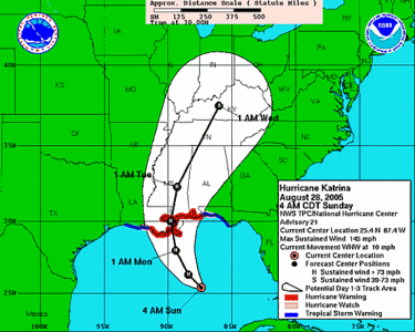
National Hurricane Center: Katrina & Projected Path
Live, Local, Weather & Travel by ZIP Code

