A strong Arctic storm is endangering Russian scientists who have been studying the Arctic from a research station anchored to moving Arctic sea ice. The Arctic ocean's surface is starting to resemble a giant frozen Margarita after being stirred by a series of storms that began in mid-May. Even the thickest ice near the Canadian archipelago is cracking up under the strain. The Russian research station, on a sea ice floe near the Queen Elizabeth Islands, where some of the thickest ice in the Arctic is normally found, is being evacuated because the ice is breaking up. Now the third strong storm in the series of Arctic ocean storms is battering the station with strong winds which are stressing the block of weakened sea ice the station is resting on.
Vladmir Putin approved a 65 million Ruble emergency mission by a nuclear powered icebreaker to rescue the research team and relocate it's scientific equipment to solid ground. The ice breaker was scheduled to leave on May 31 and arrive 10 days later. The ice platform the station was anchored to had already broken into 6 pieces before the storm, prompting the evacuation. I have seen no reports yet on how the station has withstood this storm, but it is clear from the satellite imagery that the station was affected. Russian research from Arctic sea ice stations, which began in 1937, is coming to a terrifying end as the Arctic warms and the sea ice breaks up.
Update:The site continues to produce weather data which shows that the barometric pressure is still low, but winds have not been excessively strong. The site appears to be functioning normally. Presumably, everyone is fine.
Neven posted in detail about the plight of the station over a week ago before the latest storm. Note that I am less sanguine than Neven about the cracking of the ice because I think the extensive cracking will lead to faster warming and melting come July.
The crew of the nuclear icebreaker will evacuate the team of 16 polar explorers, generators, barrels of oil and lubricants, heavy machines, a balloon, an automatic upper-air sounding station, robots, a satellite receiving station, the GLONASS system to adjust orbit and refinement of the system itself, as well as devices for the carrying out the latest oceanic and geographical and seismic research.
It was earlier reported that the Yamal icebreaker will leave Murmansk on 31 May. The journey to North Pole-40, according to preliminary information, will take 10 days.
Russian scientists are holding out today in a strong Arctic storm a threatened research station on a 2.5 meter thick slab of sea ice.
A Russian icebreaker has been dispatched to rescue the Russian polar research team, but news reports indicated it would arrive after this storm. The ice is thick enough to support the research station, but the wind stress could cause the ice to crack under it. Russian researchers, who have been studying the Arctic from sea ice stations for decades, have never had to be evacuated in this kind of emergency before. This large extent of ice break up near the Canadian archipelago appears to be unprecedented.
Canada weather's satellite image shows the storm battering the Canadian Arctic archipelago on June 5, 2013
Satellite imagery of the sea ice concentration processed by the university of Bremen shows a shocking change between June 3 and June 4 where the storm in the Canadian Archipelago suddenly reduced the sea ice concentration. Note the thinned area in the Canadian side of the Arctic ocean on June 4, then look below at the June 3 image. The day to day change is stunning. -Update- as Marsanges points out in the comments, there's likely an artifact from the storm clouds creating the yellow streak. A hole that size did not open up overnight. We will see the real effects on the sea ice in a day or two aftern the storm goes by. -End update-

Near the north pole a vast area of ice was broken up and thinned at the beginning of June by the second polar storm. Moreover, that storm has sped up the movement of large amounts of ice from the central Arctic towards the Fram strait, the final passage of sea ice before it melts in the north Atlantic. The Navy model appears to be overestimating the strength and thickness of the sea ice, but it appears to have handled the thinning and spreading effects of the storms well. Last year's record melt left a very small area of thick multi-year sea ice in the Arctic. The thin first year sea ice is not strong enough to stand up to the stormy weather, so it is fragmenting and thinning from below as slightly warmer sea water rises from warmer layers below the ice to fill the fractures.
The large area that appears to be broken up is broken up. In July this type of appearance could be caused by melt ponds, but it is too early in the year and too cold for melt ponds to form.
There is a vast area of thinned, broken ice, not two nearly ice free areas near the north pole as the movie suggests. The fracturing and spinning out of ice from the north polar area by the storm has very likely stirred up the water below the ice. This stirring will increase heat flow to the ice, which will likely increase melting from below. The spreading out of the ice is causing the sea ice extent to be close to normal, but the ice is exceptionally thin.
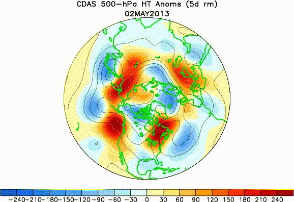
May's northern hemisphere jet stream pattern brought warmth and blocking high pressure areas to the northern areas surrounding the Arctic ocean, trapping the cold stormy weather in the central Arctic around the north pole. Note the red area of deep warm air and high surface pressure that forms over Scandinavia at the end of May. This is the blocking high that brought exceptionally warm weather to Scandinavia. Then look south of it to observe a stalled cold low pressure area over central Europe. This low pressure area, which is part of the stalled blocking pattern brought heavy rains and flooding to central Europe. These blocks and stalled low pressure patterns are an effect predicted by climate models to happen more frequently as the climate warms in response to increasing levels of greenhouse gases in the atmosphere.
Although the storms themselves are cold, a vast area of warm air is being presently pulled in towards the pole from far south over the Atlantic by the blocked jet stream. The open water in the Arctic's Barents sea, north of Norway, is much warmer than normal. This anomalously warm water is going to slowly move into the central Arctic ocean. The ultimate effect of this unusual weather pattern could be a precipitous drop in sea ice volume and thickness, but we have not yet seen the effects on volume.
The late spring storms started with a blocked jet stream over the Gulf of Alaska.
The series of storms was initiated when a blocking high pressure area sent the energy from a storm in the Aleutians into the Arctic ocean north of Alaska on May 21. Note the flow of moist air from the Pacific all the way to the north pole.
The series of storms began in mid-May north of Alaska when a blocking high pressure over the Gulf of Alaska, from the surface to the jet stream level brought the moisture and spin from a Pacific storm into the Arctic. An Arctic ocean storm developed seaward of Alaska's northern coast. It delivered a blow to the thick sea ice north of Alaska. Next, a huge blocking high and record warmth over Norway and the Murmansk area of northern Russia linked Atlantic storminess to the Arctic. In the last days of May, the jet stream moved spin from a north Atlantic storm into the Arctic, developing a strong cyclone on the Siberian side of the north pole. Like clothes in a spinning washer, the sea ice was spun away from the storm's center. (This effect is known as divergence). Now, another strong storm has spin up on the Canadian side of the pole. The Navy's model predicts this storm is thinning some of the thickest ice in the Arctic. It will create challenging conditions for the Russian research team on the wind swept ice floe. And weather models predict another strong storm to develop after this one on the Russian side of the north pole around June 10, thinning the ice there.

As of May 31st, the Arctic sea ice volume determined by University of Washington's PIOMAS model was not significantly different from the end of May levels of 2010, 2011 and 2012. The region around the north pole stayed seasonably cold in May, while the Eurasian side of the Arctic ocean experienced accelerated snow melt brought on by unseasonable warmth. In 2010 and 2012, the record sea ice thinning was preceded by a very warm May in Siberia and very early melting of Siberian snow. 2013 continues the trend of anomalously rapid Siberian snow melt in May. Dark snow free areas in spring accumulate heat, increasing Arctic warming that continues into the summer months.
Snow anomaly on May 31, 2013. Red identifies snow free areas where snow would be normally found on that date.
Sea ice volume at the end of this May is also like the past 3 (very low ice volume) years. Whatever the effects of the storm near the north pole may be, they did not affect the May 31 PIOMAS results. The Navy model shows the thinning near the pole began on June 1.
All the thinning in the areas where the ice used to be thick is taking place before the summer melt season of July where bright sunlight and above freezing temperatures melt the ice from above.
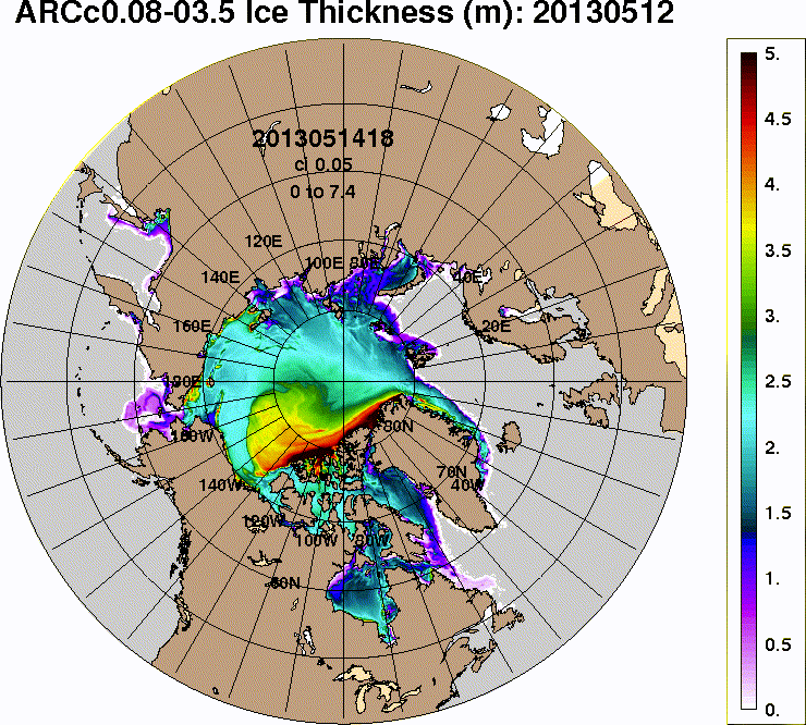
The story of the Russian research station is particularly concerning because it's located where the Navy model indicates ice should be about 3.5 meters thick, but the ice at the station is 2.5 meters thick in actuality. The Canadian archipelago is where models predict Arctic sea ice will make its last stand, but it's already breaking up.
The ice floe has now broken up in pieces that are 100 times 150 meters large, (my edit - those are rectangles of 100 x 150 meters) Head of the Federal Service for Hydrometeorology and Environmental Monitoring Aleksander Frolov says to Rossiyskaya Gazeta. The piece the research station is located on is about 2.5 meters thick. The air temperature in the area is -10 and rising.
The crew cannot be rescued by plane or helicopter, Frolov says. Because of ice ridging on the floe, it is not possible to build an airstrip for any plane, and the floe has drifted out of reach for helicopters.
Unseasonably warm 0°C air pulled in by an Arctic storm is allowing the north pole web cam's internal heat to melt ice on the lens cover on 3June, 2013. Temperatures got as high as 1°C at 88°N.
The bizarre weather that began with the sudden stratospheric warming and splitting of the polar vortex in January continues to affect the northern hemisphere. It looks like it could lead to record low sea ice areas and volumes this September, but this weather is so weird that we really don't know what's going to happen in July when the ice is most vulnerable to rapid melting. We know that much ice has been pushed by storms to the Russian side of the Arctic which has been ice free by late summer in recent years. Most of the large area of thin first year ice can be expected to melt by September. The area of thick, durable multi-year ice is very small now. Conditions are ripe for another record in ice area, extent and volume this September, but the final results depend on the weather.


