*
Update [2005-8-29 10:31:46 by nika7k]:* some of these bloggers are starting to lose power and structural integrity of their buildings. Fox is reporting flooding in the quarter and the east bank of NO.. I am updating blog entries as I get them below
Update [2005-8-29 11:25:25 by nika7k]: I have been listening to NO TV by streaming feed and they seem to have been knocked out (they are now in Mississippi to "get out of the storm track")
There are several people who are blogging from the areas affected by Katrina. (This is all thanks to the blog digging by a fellow flickerian at our
"Hurricane Katrina" flicker photo-blogging group).
Times-Picayune Hurricane Bunker Blog
Eye on Katrina Blog
Metroblogging New Orleans
Hattie's Blog
The Irish Trojan's Blog
Update [2005-8-29 14:4:58 by nika7k]:
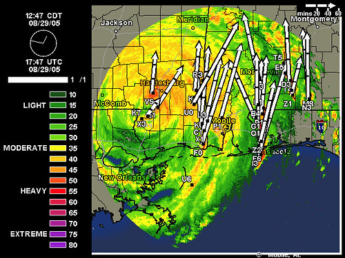
Latest radar out of Mobile, AL with wind vectors from this site: Weather Underground: Current Mobile Nexrad Radar Map
More after the jump
Update [2005-8-29 14:19:3 by nika7k]:
Here are some pics taken from
this blog who may have gotten them from
this blog (which it seems is overloaded with visits).

 Update [2005-8-29 12:4:6 by nika7k]:
Metroblogging New Orleans
Update [2005-8-29 12:4:6 by nika7k]:
Metroblogging New Orleans
*"We're talking about an east bank event rather than a West Bank event."*
Observers in City Hall are reporting broken windows in buildings up and down Loyola Ave., including the Amoco Building, which is right across the street from them.
The Coast Guard says they've gotten calls from vessels in in Southeast Louisiana as well as people who can't get through on 911 lines (probably because they're still down) with reports of people on roofs at Villere and Louisa streets and on Almonaster Drive. Those calls are going to local law enforcement via the Coast Guard because the Coast Guard can't respond to those calls, yet.
Walter Maestri, the Emergency Management Director for Jeff. Parish, said they still can't get out to verify reports of flooding. (as of about 8:45 am)
There's reports of a building collapse on Manhattan Boulevard (West Bank -- this area has been built up a lot in just the last two years, no indication what block it might be, but large apartment complexes and retail shopping centers are all along the main stretch between Lapalco and the Expressway) and a roof being blown off an apartment building at S. Judah and Ames Blvd. on the West Bank.
Maestri said, "Right now, the east bank calls are outrunning the West Bank calls by 3 to 1," he said.
Flooding in Lincoln Manor in Kenner (I think this is one of the more notorious Kenner flood-prone locations)
Breach of a levee reported by officials near East Jefferson Hospital. "The word we get is that it is not a break but must be spray from tidal surge that has overtopped the levees," he said.
The East Jefferson Levee District confirms water had breached sand bags on Airline Drive at the St. Charles Parish-Kenner line. "They tried then to drive all the levees but were just could not," he said of levee district workers.
Maestri warned we might get hurricane force winds until 2 p.m. and tropical storm force winds until 7 p.m. The storm track likely means flooding will be worst on the East Bank of Jefferson Parish.
National Weather Service has reported 12-15 foot waves in Lake Pontchartrain.
Storm downgraded to Category 3, landfall in Gulfport. Boats reported in buildings in Gulfport.
The National Hurricane Center downgraded storm surge predictions for New Orleans to 15 feet from the earlier 28 feet projection. Still enough for severe flooding. That was about 9:45am, so I expect we'll get solid info on how severe the flooding is city-wide soon. Although I think winds have to drop below 60 mph before they'll send out any crews, so potentially that could be another 9 hours according to Maestri, but more likely 4 or 5 hours if the storm keeps up its pace.
Hopefully we won't get smacked too hard by the remnants here in Columbus. But, it'll be the third hurricane after-effects we've gotten this year already, so hopefully there's not too much left to blow down.
Latest Damage Reports
Orleans:
- Levy topped, not breached, at Industrial Canal near Tennessee St. (I think that's near Holy Cross) on the Chalmette Side of the canal
- Charity Hospital on emergency power, lots of blown windows
- The Police on backup power
- Up to 4 ft. of water on St. Claude near Jackson Barracks
- 4 pumping stations knocked out by tidal surge. One has been able to resume operation
- Bridge to parking garage at Memorial hospital reported collapsed (I think this is block or two east of Charity Hospital downtown, and about two blocks north of the Dome, but I'm not positive)
Other areas:
- Jefferson Parish: Building collapse in 200 block of Wright Ave. in Terrytown (this could be apartments, a car dealership, a clinic, or even part of Oakwood Mall -- that's everything at that corner). People reportedly inside
- Significant flooding in St. Charles on the east bank
- Arabi: "We're telling people to get into the attic and take something with them to cut through the roof if necessary,'' said Col. Richard Baumy of the St. Bernard Parish Sheriff's Office. "It's the same scenario as Betsy.'' Up to 8 feet of water there. Baumy said hurricane winds were preventing rescue efforts.
- Bayou Bienvenue reporting levels at twice normal (9.5 ft.)
- Fire station in Gramercy has been damaged
- Power outages everywhere
More conflicting *Superdome* reports: Water reported pouring in through damage in roof, 2 sections missing, people moved from a section of Dome floor (I thought they weren't allowed on the floor already because of flooding concerns??? -- this whole dome report might be inaccurate) and people moved to the end zone and up into concourses.
Update:
- Oschner Hospital reports flooding according to WDSU, patients being moved to upper floors.
Update II:
- East Jefferson Hospital, too, reports water on the first floor.
Update [2005-8-29 11:25:25 by nika7k]: The Irish Trojan's Blog The latest
8/29/2005 10:01:00 AM EST
Posted by Brendan Loy
Significant flooding in St. Bernard Parish, according to The Weather Channel.
Stu Ostro says the worst time for northerly winds blowing the water out of Lake Pontchartrain into the city is right now, and for maybe the next 30-60 minutes. After that, the winds will change direction as the storm moves away. (It's a very good thing that it sped up overnight.)
From WDSU: "9:25 a.m.: East Jefferson Hospital Also Flooding: There are also reports of water on the lower floor of East Jefferson Hospital. The flooding may be related to unconfirmed reports of levee breaks along industrial canals in the area."
"9:45 a.m.: Homeowner Says Water Rising: Chris Robinson says the water is rising in his New Orleans-area home, but he's 'holding off on breaking through the roof' to escape. Robinson is keeping a hammer, ax and crowbar at the ready, though. He spoke by cellphone as water sent by Hurricane Katrina flooded parts of the city. -- Associated Press"
"9:47 a.m.: Boats In Buildings In Gulfport: In Gulfport, Miss., a fire chief says there are 'boats that have gone into buildings.' Waves are also crashing over the seawalls in Gulf Shores, Ala. -- Associated Press"
An oil tanker which had previously broken free of its moorings in Mobile Bay has now been secured, according to TWC's Mike Seidel. Officials aren't sure if any oil leaked.
Update [2005-8-29 10:57:2 by nika7k]:
Times-Picayune Hurricane Bunker Blog
Monday, August 29, 2005
New Orleans is sinking . . .
I don't want to swim
9:34 - Reports of widespread flooding now, although not at the doomsday scenario levels. But we've got several hours to go before we've seen the worst past. Scanner traffic is busy with calls of rising water, including 18 inches and rising against the levee in the French Quarter. Dispatchers questioning officers on the scene, trying to determine if there is a break in the river levee, or if water is pouring over the top. Independently, NOLA has received a flooding alert for the French Market area.
Fairly heavy street flooding in front and behind the Times-Picayune . . . water appears about knee deep, whipped by the steady wind into whitecaps and breakers. Water is hubcap deep on the furthest vehicles in the employee parking lot, and rising quickly.
Update [2005-8-29 10:41:40 by nika7k]: Another local blogger
Josh Britton
"Superdome update
August 29th, 2005 @ 9:29 am
CNN’s Jeanne Meserve just reported that the white outer membrane of the Superdome’s roof is “shredded”, and that there is no indication that folks are being moved inside."
*
Update [2005-8-29 10:31:46 by nika7k]:*
The Irish Trojan's Blog:
"Collapsed buildings, massive flooding" in N.O.
8/29/2005 09:21:00 AM EST
Posted by Brendan Loy
NOLA reports:
During a morning teleconference, emergency preparedness officials from across southeast Louisiana reported flooding, building collapses, power outages and fires.
Here's a run-down of what they reported:
- In New Orleans, water topped a levee along the Industrial Canal. The city's 911 emergency system was out of service and Charity Hospital was on emergency power and windows had been blown out on five floors. The Police Department was operating on a backup power system. Three to four feet of water was reported on St. Claude Avenue at Jackson Barracks. And a 20-foot tidal surge knocked out four pumping stations; only one was able to get back into service.
Also in New Orleans, a bridge connecting a parking garage to Memorial Hospital collapsed.
- In Jefferson Parish, there was a report of a building collapse in the 200 block of Wright Avenue in Terrytown. Parish officials could not provide details other than to say they had been notified that people were inside the building.
- In St. Charles Parish, significant flooding was reported on the east bank.
- In Arabi, up to 8 feet of water was reported, and people are climbing into their attics to escape the flooding. "We're telling people to get into the attic and take something with them to cut through the roof if necessary,'' said Col. Richard Baumy of the St. Bernard Parish Sheriff's Office. "It's the same scenario as Betsy.''
Baumy said 100-plus mph winds were preventing rescue efforts.
At Bayou Bienvenue, water levels were reported at 9 1/2 feet, almost twice normal levels.
- In St. John, massive power outages are reported.
- In Gramercy, there was extensive damage to the town's 1 1/2-year-old fire station.
- Terrebonne Parish reported a fatality from a heart attack.
Also, there are massive power outages, unsurprisingly.
Times-Picayune Hurricane Bunker Blog: (The reporters from New Orleans TP that are left are riding the storm out on the third floor of the T-P's offices now on generator power.) Outside the one window that's not now heavily shuttered, we can see the trees in the newspaper's parking circle whipping wildly. ... I'm looking at the wind smashing the trees outside this building, and thinking of those 80-foot-tall pines that snap off even during tropical storms. And that storm surge. All we can do now is pray for our family members in harm's way. ... most frantic calls about downtown hotels, where a number of windows have blown out. Guests huddling in halls. Water blowing in through windows, leaking through ceilings. ... Building collapse reported on Laurel near Washington in the Garden District . . . possibly with people inside. Emergency workers trying to see if they can get a National Guard deuce-and-a-half to get through the storm for possible rescue.
Eye on Katrina Blog: (Two Mississippi Sun Herald's reporters are blogging from the Coast.) There are two sailboats in the intersection of U.S. 90 and 25th Avenue, and multiple boats in Jones Park, where the water is to the bottom of the oak trees. Water is getting into First Baptist Church, and it's in the parking lot at the Gulfport Library. O'Brien was out with two other firemen in a GFD pickup truck, and they said water was getting into the elevator lobby of the Grand Casino hotel south of 90 and they thought it was getting into the gambling barge's first floor. ... The wind is whipping now. The roof on the building is creaking. You can hear the building's joints straining. ... They've got 9 feet of water in Waveland. She thinks they've lost part of the back of the courthouse over there. There are houses in Bay St. Louis that don't normally flood that have water up to the doorknobs. ... Dee Lumpkin said she was unable to give a windspeed, as their anemometer on the mast on top of their building had broken.
Metrobloggin g New Orleans: Air conditioning out at Louisiana Superdome due to power outages. But they did get MREs delivered by Orleans Parish workers early early this morning. Something like 350,000. But wow, 30-40,000 people in a building with no A/C. They will be asked to stay there if there is prolonged flooding. 15 semis of bottled water were delivered, as well. I estimate the interior of the dome s under a Category 4 Misery watch and may see Category 6 or 7 Misery levels before they are able to leave. ... CNN is apparently reporting that a portion of the Superdome roof is peeling away, but this is likely just the outer layer of foam, not the underlying steel roof panels.
Hattie's Blog: From Hattiesburg, Mississippi, about 70-90 miles north of the Mississippi Gulf Coast. Lots of crazy wind here in Hattiesburg. Small branches down. Very light rain. Though New Orleans may not be getting the smackdown that was expected, it is worse here this morning than I expected. I sort of thoughtwe would be at this level of bluster more towards noon. ... We are about to have to head to the hallway, I think. Pretty serious gusts and we should be under tornado warning and not just a watch here in a few. ...I'm out, guys. Something big just fell on the house. Next up, Jennifer will be taking over.
The Irish Trojan's Blog: Initial report from West Jefferson Medical Center - She is ok, but the hospital is on its last leg of backup power (how absurdly inadequate?). They heard that at East Jefferson, in Metairie, across the river from them, that there was flooding on the lowest level of the hospital. Confirmed on WWL TV. ... Whether the storm surge and waves will nevertheless be enough to overwhelm the levees, and if so, to what extent, remains to be seen. But compared to the general despair of 24 and even 12 (hell, 6) hours ago, things are definitely looking up for the possibility that New Orleans as we know it will survive to see another day. ... WDSU's reporter in the Superdome is reporting that at least one section of the Dome is leaking and getting worse. According to the phone report, he couldn't see sky but they felt increasing rain falling on them and were planning to move to a more protected area around the concession stands. ... On an early morning radio interview, New Orleans Mayor Ray Nagin said that water was coming over the levee system in the Lower 9th Ward, especially in the Florida Avenue area. Nagin said that the Florida Avenue pumping station was not working, and there were unconfirmed reports of people standing on their roofs. "There is a significant amount of water in the 9th Ward," Nagin said. Nagin said that city officials had reports of at least five fires in the city and one collapsed building. The locations of the fires and the building were not specified.
