Today's Arctic sea ice extent is hovering at the historic record low level for today's date observed in 2007. Warm water entering the ice free zone from the Atlantic ocean is adding heat to the Arctic, changing the northern hemisphere atmospheric circulation pattern - the weather of the whole northern hemisphere. Even El Nino is different from what it used to be.
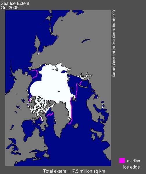
Figure 1. Arctic sea ice extent for October 2009 was 7.50 million square kilometers (2.90 million square miles). The magenta line shows the 1979 to 2000 median extent for that month. The black cross indicates the geographic North Pole.FishOutofWater
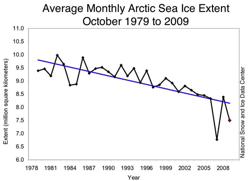
Since October 1979 melting sea ice has exposed 2 million square kilometers of open water, releasing heat and water vapor to the Arctic atmosphere.
By FishOutofWater
Arctic storm intensity and precipitation amounts are increasing because of the open water.
A new study by Ian Simmonds and Kevin Keay, at the University of Melbourne in Australia, finds connections between the decline in September sea ice extent and the characteristics of Arctic storms. As ice extent has decreased, Arctic storms have shown a tendency to become more intense, especially in the last few years. The study suggests that low September ice extent, with extensive areas of open water, provides more energy to autumn storms, allowing them to become stronger. The stronger storms also help to break up the ice.
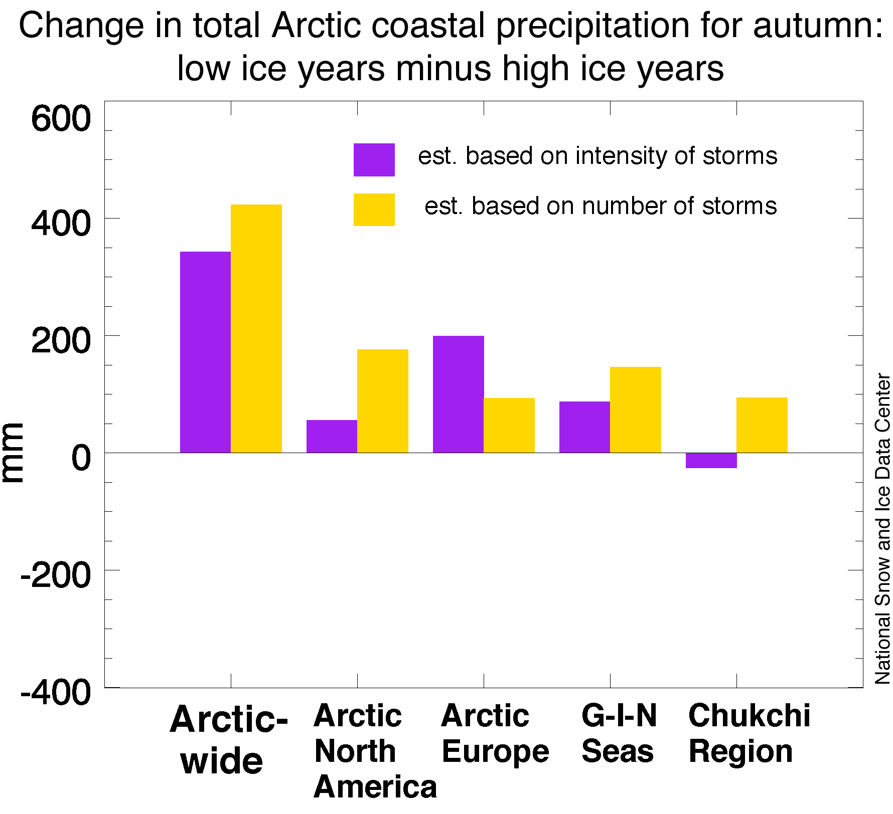
Related research at NSIDC reveals that when September ice extent is unusually low, precipitation linked to Arctic storms tends to be greater than when September ice extent is unusually high (Figure 5).
By FishOutofWater
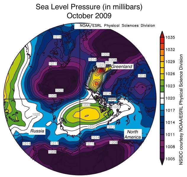
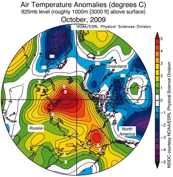
In the fall, high pressure forms over central Siberia and Greenland as the air cools and sinks. The anomalous warm open water in the Arctic tends to form a low pressure area. This October, an exceptionally strong low pressure area formed over the warm open water.
By FishOutofWater
The low pressure area drove strong southerly winds in the region bounding the sea ice and open water. This warm wind raised temperatures to as high as 11 degrees Fahrenheit above normal in the Arctic, greatly reducing the formation of additional sea ice. Moreover, because water in the northern hemisphere is driven 90 degrees to the right of the winds, the warm water is being driven further into the Siberian Arctic.
By FishOutofWater
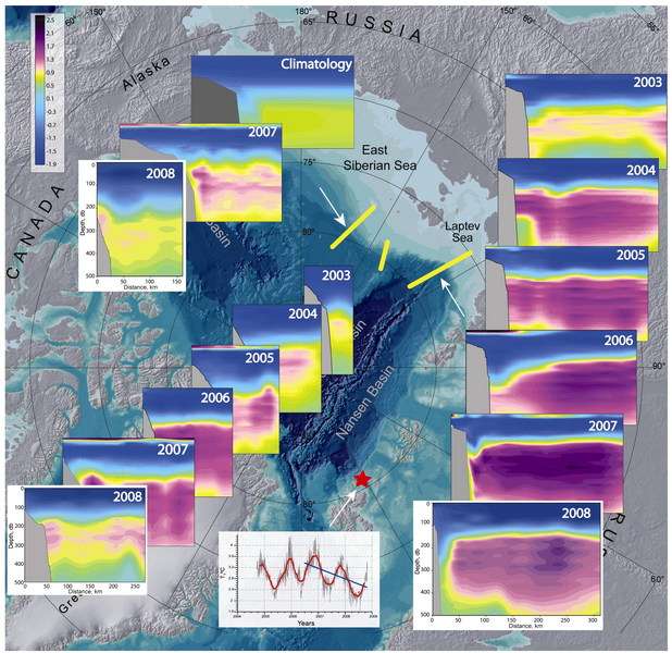
Exceptionally warm water that contributed to the record Atlantic hurricane season in fall 2005 apparently began to affect the Arctic ocean in the winters of 2006 and 2007. The record minimum sea ice year of 2007 is associated with the presence of a warm mass of Atlantic origin water in the central Arctic ocean.
By FishOutofWater
The warm water the pushed into the Arctic in fall 2005 caused the disappearance of most of the multi-year sea ice in the Arctic.It appears that another cycle of warm water entering the central Arctic is beginning this fall.
Warm open water in the fall and thin ice in the winter are heating the Arctic atmosphere from below. There is now evidence that this heat is changing the northern hemisphere's atmospheric circulation patterns - the weather of the northern hemisphere.
There is evidence that, by creating a new major surface heat source, the recent extreme loss of summer sea ice extent is having a direct feedback effect on the general atmospheric circulation into the winter season (Francis et al., 2009). Fall air temperature anomalies of greater than +1.0° C were observed well up into the atmosphere (Figure 3A), when averaged over 2003-2008 relative to a 1968-1996 base period. The higher temperatures in the lower troposphere decrease the atmospheric air density and raise the height of upper-air-constant-pressure levels over the Arctic Ocean (Figure 3B). These increased heights north of 75 °N weaken the normal north-to-south pressure gradient that drives the normal west-to-east airflow in the upper troposphere. In this sense, the effect of higher air temperatures in the lower Arctic atmosphere is contributing to changes in the atmospheric circulation in both the Arctic and northern mid-latitudes. For example, Honda et al. (2009) suggest a remote connection between loss of Arctic sea ice and colder temperatures over eastern Asia.
By FishOutofWater
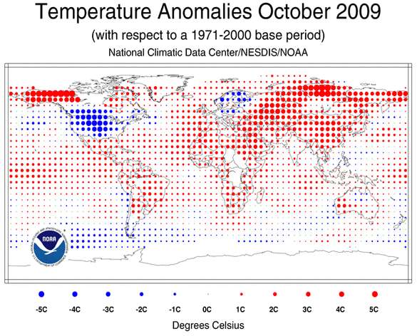
El Nino and very warm temperatures in the Arctic led to the warmest June through October on record according to NASA and Joe Romm at Climate Progress.
By FishOutofWater
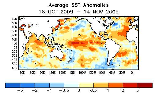
Even El Nino is changing as the oceans warm. A form of El Nino called "El Nino Modokai"where unusually warm water moves along the equator from the western Pacific to the central Pacific, but doesn't make it to the west coast of the Americas as in a regular El Nino, is becoming more common.
The ENSO Modoki events significantly influence the temperature and precipitation over many parts of the globe. Depending on the season, the impacts over regions such as the Far East including Japan, New Zealand, western coast of United States, etc., are opposite to those of the conventional ENSO. The difference maps between the two periods of 1979–2004 and 1958–1978 for various oceanic/atmospheric variables suggest that the recent weakening of equatorial easterlies related to weakened zonal sea surface temperature gradient led to more flattening of the thermocline. This appears to be a cause of more frequent and persistent occurrence of the ENSO Modoki event during recent decades.
These El Nino Modoki events may be associated with the warming of the Atlantic ocean and a strong Atlantic hurricane seasons.
The discovery of a different mode of El Nino that led to increased storms "was quite startling," she said.
In 2004 an El Nino was developing, causing forecasters to expect fewer Atlantic hurricanes.
But instead it turned out to be one of the Modoki years. There were 15 named storms, including six major hurricanes. Overall activity was nearly two and a half times the long-term average, resulting in more than 3,100 deaths in the region including 60 in the United States. There was record property damage in the United States.
The present El Nino is still strongest in the central Pacific, but it's too early to say whether it's a "Modokai" event. NOAA Models are predicting it to be a "normal" El Nino. This fall's Atlantic hurricane season was disrupted by wind shear from the El Nino. Models of this El Nino forecast a warmer than northern equatorial Atlantic next summer. Conditions appear to be developing for a strong Atlantic hurricane season next year.
By FishOutofWater
And, yes, there may be a connection between the El Nino events, warming in the Atlantic, and warming in the Arctic.
