Blasting the Bird's Point levees on the Mississippi River near Cairo, Illinois was necessary to save the town of Cairo and large areas of Memphis, Tennessee downstream. Record high water levels at the confluence of the Mississippi and Ohio rivers were dropped to safer levels by blowing up the levees and opening up the flood plain. Detailed hydrometorological forecasts show that Cairo appears to have been saved. However, major transportation corridors are forecast to be cut off in Memphis and areas further downstream down to northern Louisiana will be threatened by the potential for severe flooding through the month of May. The Army Corps of Engineers apparently plans to open the large spillway that flows into lake Pontchartrain to protect New Orleans. River forecasts for New Orleans indicate that New Orleans will not flood unless additional rains raise water levels.
High groundwater pressure continues to threaten Cairo. A sand boil will grow by erosion into an uncontrollable flood if it's unplugged. The Army Corps continues patrolling for and plugging boils. However, the flood crest will continue to push downstream towards New Orleans through the month of May. The possibility of more rain adds uncertainty to downstream forecasts.
Blasting the levees will inundate 130,000 acres of Missouri farmland in addition to the 100,000 acres already flooded in the area. So many crops will be lost to flooding that food prices will be driven up. The damage is projected by local authorities to come to hundreds of millions of dollars.
"In that spillway, all the structures are going to be gone," said Blake Hurst, head of the Missouri Farm Bureau. "Roads, bridges, center point irrigation pivots are all going down the river."
The corps dynamited the levee to relieve mounting pressure on the flood control systems guarding more populated areas upriver, particularly Cairo, Ill. But the decision exacted a heavy price: Some early estimates put the damage at $300 million. Hurst says he believes that's low, predicting the crop damage alone to be around the $100 million mark.
Hurst and others stress that, while the explosion flooded 130,000 acres in the spillway near the levee, an additional 100,000 in the area are underwater from the 20 inches of rain that have fallen in the past two weeks.
Record flood levels are predicted downstream in late May by the Army Corps of Engineers.
On Monday afternoon, the National Weather Service (NWS) and the U.S. Army Corps of Engineers (USACE) upped the ante on those river forecasts, calling for the potential for all-time record river stages at Red River Landing (65.5 ft) and Baton Rouge (47.5 ft) on or about May 21st. Down river at Donaldsonville, the forecast for 36.0 ft would effectively tie the record stage for that location. In addition, the Atchafalaya at Morgan City is projected to rise to 9.5 ft, which would be the second highest stage ever for that site.
| This liveblog group is being set up for the community to come together to report and raise awareness of this extreme flood event. Images are welcome if they convey important content. Given the nature of this developing event discussion needs to be kept informative and supportive. Residents affected by these floods need to follow official sources. These liveblogs are intended to assist in awareness, planning and support. Because increasing incidence of severe flooding is a predicted consequence of climate change caused by human emissions of CO2 into the atmosphere, one of the purposes of this group is to raise awareness of the destructive consequences of climate change.
Human caused global warming didn't make the floods. It made them worse.
|
Detailed information with images, graphics and videos, follows the break.
The wettest April on record in in many towns in the heart of the Ohio and Mississippi Valleys, following a winter with a heavy snow pack in the northern Mississippi valley, caused a record flood crest where the Ohio river meets the Mississippi. Over 20 inches of rain, fueled by near record warmth in the Gulf of Mexico, fell in the month of April at the wettest locations.
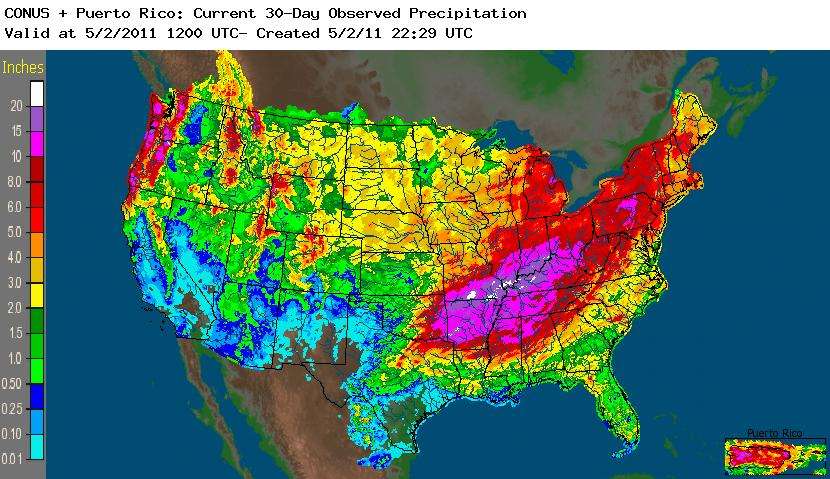
The north Atlantic has been consistently warmer than normal since 2005. Increasing amounts of heat resulting from greenhouse gas emissions are being stored in the warm pool in the north Atlantic. This year winds blew the warm pool towards the Gulf of Mexico and the southeastern U.S. The exceptionally warm water provided enormous amounts of water vapor that fueled severe thunderstorms, record numbers of tornadoes for April and record amounts of rain.

Exceptional amounts of "precipitable water" were available to severe thunderstorms that fed off of moisture that strong southerly winds evaporated off warm Gulf of Mexico.
Rainfall from Thursday, April 22 through Thursday, April 27:
• Evansville...7.22
• Paducah...10.59
• Madisonville, KY (KY mesonet)...7.54
• Carbondale...10.58
• Cape Girardeau...14.96
• Poplar Bluff...16.16
This video gives an aerial view of the record flooding at Bird's Point.
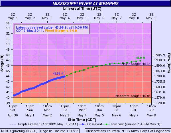
Record flood levels and forecast levels at Cairo Il before the levees were blasted.

Army Corps frame that captures the moment of blasting the levee.
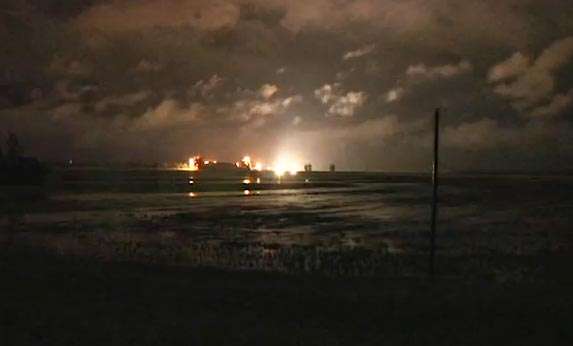
Blasting the levees quickly lowered the flood crest by diverting water in to the wide flood plain.

However, NOAA is still predicting that thousands of Memphis residents will see their property flooded over the next week as the record flood crest reaches Memphis. Moreover, in mid to late May, as the flood crest approaches New Orleans, the Army Corps of Engineers is anticipating taking further emergency measures to protect New Orleans from potentially devastating flooding.
Shelby County Emergency Operations Center Flood Warning Reports that 5300 homes and businesses in the Memphis area are forecast to be affected by the flood. Here is the link to the detailed map of projected flooding in the Memphis area. PDF
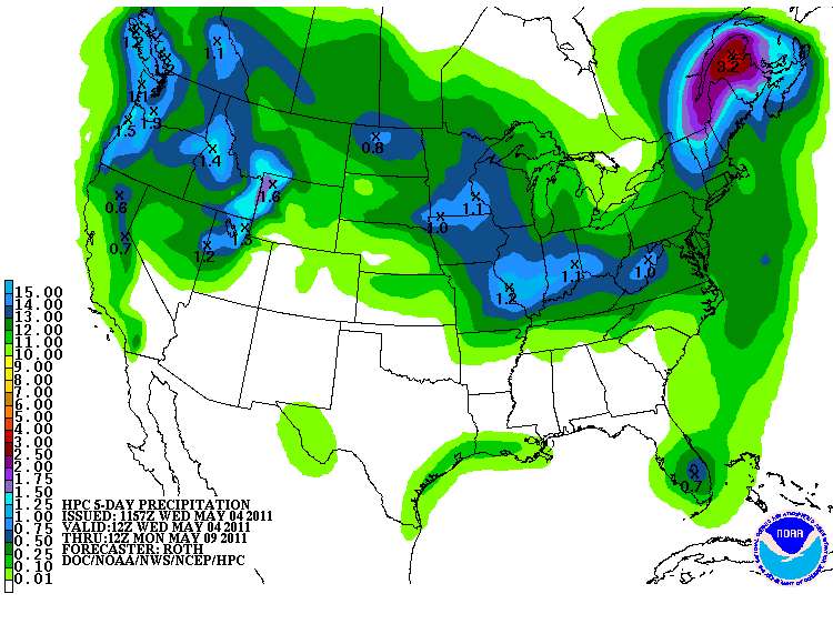
More rain is forecast for the Mississippi and Ohio river valleys over the next 5 days, but it is not expected to be heavy.