Some lands are so ancient, it's like they're forever new. Libya's like that – from Neolithic times before the dawn of history, down through Egyptians, Carthaginians, Greeks, Romans, and Muslims, the ancient peoples of Libya's coasts and deserts assimilated new ideas and made tradeworthy accommodation (eventually) with all comers. The political entity we think of as a somewhat-misshapen box on Africa's Mediterranean shore only came into existence in 1951; prior to that, Libya had, like so many other lands in regions of overlapping imperial interests, changed hands many times as the powerful waxed and waned.
Join me, if you will, in the Cave of the Moonbat, where tonight we'll look at some of the Libya-attacking that went on the ancient lands of Tripolitania, Cyrenaica, and Fezzan. Consider it a prelude to the other three diaries in this series, which concern themselves with Libya-attacking in the Middle Ages, in the World Wars, and in the modern era. Don't worry, though – it'll be a couple of thousand years before we have to start worrying about Nazi tanks – so grab your trusty saif, mount up your camel, and meet me at the nearest oasis.
Historiorant: This diary was originally published on April 22, 2007, and was (and is) dedicated to our own Meteor Blades and his family, who have experienced significant grief at the hands of the Gaddafi regime.
It's All About the Geography
The modern nation of Libya is not one of those ones that's defined by easy-to-read topographic borders. There are no rivers or large lakes, nor ranges of mountains or other convenient features, to separate it from neighbors – only a narrow strip of coastal lowlands, a rugged, north-facing escarpment, and the vast desert to the south exist to delineate its regions. Here's a modern political map, from CIA Factbook:
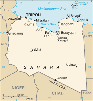
For all you numbers freaks and relative geography enthusiasts out there, Libya has a land area of nearly 1.76 million square kilometers, which makes it slightly larger than the State of Alaska (with which it shares the additional coincidence of sitting atop massive oil reserves). Libya also shares – and sometimes disputes – its 4348-kilometer borders with Egypt, Chad, Algeria, Tunisia, Sudan, and Niger, and possesses a 1770-kilometer coastline, along which 80% of the population resides. Oh, and it's damn hot: though diurnal conditions in the desert can drop the temperatures to freezing at night, daytime temperatures can get so furnace-like that they set records: famously, al-Azizyah, Libya, is listed as having the highest temperature ever recorded – 136 degrees Fahrenheit on September 13, 1922.
Desertification made less and less of the land suitable for planting over the course of plodding, inevitable centuries – today, only 1.03% is considered arable, and over 90% of Libya's territory is classified as desert or semi-desert – which obliged the people who lived there to adapt for survival in the harsh conditions. As in such environments in other parts of Planet Earth, people tended to become nomadic, taking advantage of their knowledge of microclimates and conditions in the changing seasons.
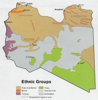
Ancient peoples weren't quite as obsessed with straight lines as the folks in the U.N. decolonization committees were – they divvied things up more according to convenience of travel and ease of access, so the borders of "Libya" were often indistinct, especially in the Fezzan, the desert areas of the south and west. Along the coast, two main regions developed: Cyrenaica in the east, which was largely influenced by Greece, Egypt, and the Mashriq (eastern Islamic world), and Tripolitania, whose history is intertwined with Carthage, Rome, and the Maghrib (Mashriq's western counterpart). Here's a 1974 map from the Perry-Castaneda Map Collection showing various tribal groups, and the relative location of the three main regions:
The Good Old Days
Neolithic culture was alive and well in Libya by the 7th millennium BCE, flourishing on a broad, well-watered savanna that stretched far to the south - petroglyphs of elephants, giraffes, and other non-desert dwelling beasts show that the area wasn't always a desert. Sometime around 2000 BCE, the process of desiccation accelerated, the beasts moved away, and the Sahara inched northward and southward a little each year, on its way to becoming the broad swath of uninhabitability we know and love today. The people of the savanna migrated toward the more fertile fields of the Sudan, or stayed put and melded into the tribes of Berbers, who'd been arriving from the east for the past few hundred years.
The origin of the Berbers is hard to pinpoint. They're Caucasian, of Mediterranean stock, but identify themselves primarily by tribe, clan, and family rather than by nationhood or land of origin. Ranging from Egypt to the Niger Basin, they speak mutually unintelligible languages of the Afro-Asiatic language family; collectively, they refer to themselves as imazaghan ("free men"). Old Kingdom records from Egypt (ca 2649-2150 BCE) show evidence of Berber migrations and troublesome border incidents; one possible origin of the term "Libya" is via these documents, which identify one of the unruly tribes the "Levu" and mentions that they'd been raiding and attempting to settle in the Nile River Delta.
Things didn't go quite as well for the Berbers during the Middle Kingdom (2040-1640 BCE), as the pharaohs were able to extend their dominance over them and begin exacting tribute. As is so often the case with overlorded peoples, Berbers began serving in the Egyptian army in large numbers, and eventually started making their way up the pharaoic social ladder. Around 950 BCE, a Berber officer usurped the reigning pharaoh, installed himself as Shishonk I, and established the Twenty-Second and Twenty-Third Dynasties (the so-called "Libyan Dynasties"), which lasted from 945-730 BCE (though there is some debate over the exact dates). Some indication of the political situation over which these kings reigned can be garnered from the blurb in this excellent compilation of pharaoh's names:
Libyan kings ruling in Tanis and Bubastis, recognized in all of Egypt until 828, when a rival Libyan dynasty arose in Thebes. In 814 another rival dynasty arose in Leontopolis in the Delta. Dynasty XXII was still recognized in Memphis and parts of the Delta until 735 and intermittently in Thebes until 787/783.
The contraction of the Egyptian Empire brought on by its internal dissention allowed for enterprising civilizations to begin establishing beachheads on its peripheries, and in the Ancient Mediterranean, there was nobody more enterprising the Phoenecians. Like much-later sheikhs with their oil holdings, the Phoenicians wielded control over the precious purple dye prized by ancient rulers everywhere, and constructed trading posts along the North African coast to service the ships of the trading empires cultivated by mighty cities like Tyre and Sidon. Some of these outposts grew into cities in their own right, and a couple of them managed to develop distinct cultures of that went on to play a large role in the affairs of other later Mediterranean powers.
Punic: It Ain't Just for Wars Anymore
According to tradition, Carthage was founded in 814 BCE by Queen Dido (Virgil's name, she's a/k/a Elissa or Elissar), who was fleeing a pretty dysfunctional family scene in Tyre. Upon landing on what's now the coast of Tunisia, Dido is said to have asked some locals for a patch of land on which to encamp, to which they replied, "sure, you can have as much territory as an ox-hide can cover." In one of history's classic Ferengi-type moves, Dido ordered an ox-hide to be sliced into razor-thin strips, which she then used to encircle a pretty sizable chunk of territory.
Carthage went on to extend its dominion across much of the African coast, Sicily, and eventually into Spain. In so doing, it developed a unique, Phoenicia-based culture of its own, and this "Punic" (from the Latin Punici, "Phoenician") civilization extended its influence into the societies of the Berber tribes with which it cultivated trade relations. When Rome was falling, 700 years after the destruction of Carthage, Berbers in the Libyan hinterlands were still speaking Punic and worshipping Carthaginian idols. Punic was, of course, the dominant culture in those towns founded by the Carthaginians along the Libyan coast – especially Oea (Tripoli), Labdah (later Leptis Magna), and Sabratah, which eventually grew into an Late Bronze/Early Iron Age metropolis known collectively as Tripolis, or "Three Cities."
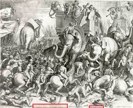
Carthage and Rome eventually went at it, the way that emerging superpowers seem to do, and though the story of the Punic Wars is one that's gonna have to get moonbatified at some point, it's simply too involved for more than a cursory treatment here. Suffice to say that Carthage eventually got delenda ested, and her territories were awarded as spoils to the King of Numidia, who had wisely backed the Romans. Regrettably (from the point of view of a Numidian monarch), the king in 146 BCE proved better at picking winners than the one a hundred years later, who made the mistake of throwing his support to Pompey instead of Julius Caesar in the Roman Civil War that followed Caesar's Rubicon-crossing. Once Pompey was removed from leadership contention by assassination, Augustus Caesar reorganized Tripolitania as a Roman province.
Growing Up In Magna Graecia
A couple of hundred years after the establishment of Carthage, the story goes, Hellenic colonists from the island of Thera followed instructions given them by the Oracle at Delphi and set out for the North African coast. They landed several hundred kilometers east of Tripolitania – closer to Crete than Carthage – and there met local Berbers who conducted the settlers about 20 kilometers inland, spread their arms wide, and intimated that a "hole in the heavens" above the broad, fertile plain upon which they stood would make this an excellent spot for one of those fixed living spaces that the non-nomads seemed to prefer for their trading. Recognizing good advice when they heard it, the Greeks founded the city of Cyrene on the site in 631 BCE, which went on to become mother to a cluster of highly-competitive-with-one-another towns that, together with Cyrene, became known as the Pentapolis ("Five Cities"): Barce (Al Marj); Euhesperides (later Berenice, present-day Benghazi); Teuchira (later Arsinoe, present-day Tukrah); and Apollonia (Susah), the port of Cyrene.
The politics of Cyrene are convulsive; control of the region passes among ancient power brokers with great frequency. In one of the better examples of hitting history's fast-forward button I've seen recently, the Library of Congress Countrystudy of Libya does an admirable job of truncating a few centuries into a paragraph:
The Greeks of the Pentapolis resisted encroachments by the Egyptians from the east as well as by the Carthaginians from the west, but in 525 B.C. the army of Cambyses (son of Cyrus the Great, King of Persia), fresh from the conquest of Egypt, overran Cyrenaica, which for the next two centuries remained under Persian or Egyptian rule. Alexander the Great was greeted by the Greeks when he entered Cyrenaica in 331 B.C. When Alexander died in 323 B.C., his empire was divided among his Macedonian generals. Egypt, with Cyrene, went to Ptolemy, a general under Alexander who took over his African and Syrian possessions; the other Greek citystates of the Pentapolis retained their autonomy. However, the inability of the city-states to maintain stable governments led the Ptolemies to impose workable constitutions on them. Later, a federation of the Pentapolis was formed that was customarily ruled by a king drawn from the Ptolemaic royal house. Ptolemy Apion, the last Greek ruler, bequeathed Cyrenaica to Rome, which formally annexed the region in 74 B.C. and joined it to Crete as a Roman province.
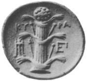
Existing in a different sphere from the region's politics, the cities profited from a booming economy based on grain, wine, stockbreeding, wool, and silphium, a member of the parsley family with a reputation as an aphrodisiac, contraceptive, and medicinal herb. The resin of the silphium was used throughout the Mediterranean, and the Republican Romans considered it worth its weight in denarii – until a variety of natural and man-made factors led to the very last stalk being handed to Emperor Nero "as a curiosity."
Cyrene's beautiful climate and proximity to Pliny-approved medicinal plants led to its becoming a center of learning and flourishing culture in the Hellenistic world. A medical school and other academies of learning attracted scholars and architects. California-like, the ease of life and propensity for brilliance in the field of navel-gazing gave rise to a peculiar form of skeptical hedonism – in this case, the Cyrenaics, who defined as the highest good the sum of human pleasures, and rigidly held to a doctrine of never deferring a physical pleasure until later.
Moniker of the Mysterious: The Garamentes of Fezzan
Sometime before 1000 BCE, a group of nomads looked south of the narrow coastal strip and decided that if no one else was going to claim the desert, they would. They recognized that the sands and sun would kill anyone who deviated from a proscribed path of oases, and so determined that there was no need to use their resources in trying to defend a desert border; all they needed to do was garrison the watering holes. In this manner – along a string of oases about 400 km long – the Garamentes were able to control the routes between Sudan and the Mediterranean coast, west to Mauritania, south to the Niger River, and eastward as far as Egypt.
Recent archaeology has shown the Garamentes from being far more than Herodotus' description of a tribe of numerous barbarians who were good at raising cattle; indeed, they became the Sahara's first culture to develop an urban civilization absent a perennial river – by 150 BCE, their capitol, Gerna (the modern Jarma Oasis) had a population or perhaps 4000, with another 6000 living in the immediate vicinity. Eight more major towns and numerous smaller settlements dotted their realm, and a decidedly city-based culture developed to exploit transiting caravans. According to some estimates, over 50,000 of their pyramidical stone tombs dot the landscape of their former territory.
Weird Historical Sidenote: For a glimpse into what the territory of the Garamedes looks like nowadays, check out this guy's photologue of a trip to Tassili National Park in Algeria. See if you can spot the petrified elephant.
They were able to accomplish all this by means of an ingenious system of more than 1600 kilometers of foggares (tunnels), dug down to subterranean aquifers and used to supply irrigation systems on the surface, and through an effective means of written communication. The Garamendes' Phoenecian-based alphabet

is still in use by some Tarureg tribes today, have largely been preserved through the good offices of multiple generations of desert-dwelling women.
Their elaborate tunnel system made the Garamedes overly reliant upon slaves, which led to the old conquer-or-perish motif that we see played out so often through history. They warred for control of trade (and for profit) with the kingdoms surrounding them, be they Nubian, Egyptian, Carthaginian, Greek, or Roman. These latter sent several punitive expeditions into the lands of the Garamedes, but the desert proved unconquerable; finally, the Romans gave up and signed a lasting commercial and military agreement with them at the end of the 1st century CE.
A Pax Upon You
For 400 mostly-peaceful years, Tripolitania and Cyrenaica existed as provinces of Rome, and partook of all the forums, amphitheaters, and inter-imperial trade that such a status had to offer. The two metropoli remained decidedly distinctive in flavor, however: Tripolitania, which traded in gold and slaves with Garamedes and olive oil with the rest of the Empire, was Punic in language and culture; Cyrenaica, which specialized in horses, wine, and drugs, remained Greek. It wasn't until the late first century CE that the two regions were linked by land, when the Romans finally managed to pacify Sirtica, the long strip of coastal land between Tripoli and Cyrene. For the next 200 years, the Romans guarded the entire area with about 1½ legions and some locally recruited auxiliaries, and outside of a few incidents of terrific violence, fared none the worse for their confident neglect.
One of these incidents might fall under the "coming home to roost" category. Since the days of the Ptolomies, Cyrenaica had been home to a large Jewish community. This expanded by tens of thousands in the years following the Roman suppression of the Great Revolt (66-70 C.E.), as Jewish exiles, refugees, and slaves poured in from recently-recaptured Judea. Tens of thousands of these "scattered seeds" came to the cities, while others were assimilated into Berber tribes. Sometimes that assimilation seems to have worked both ways – entire tribes were converted to Judaism. By 115 CE, pent-up rage at Roman oppression led to an uprising that saw Cyrene sacked, and a swath of destruction cut across northern Egypt and into Palestine. When the dust settled upon the jacksandals of the legions three years later, estimates placed the death toll at over 200,000, and Cyrene was left in such a state that it would require a quarter century to regain its economic footing.
Diocletian was the first to use "Libya" as a political designation, which he did as part of the reorganization surrounding his splitting of the Empire into Eastern and Western halves. In his decree of 300 CE, Cyrenaica was detached from Crete into the provinces of Upper and Lower Libya, while Tripolitania was attached to the Western Empire. This division had implications beyond the political, for religion was increasingly becoming something perceived as being worth fighting over: Tripolitania would fall under the domain of the Catholic Patriarch of Rome, while Cyrenaica came under the jurisdiction of the Coptic Patriarch of Alexandria.
In 429, a rebellious official invited the "military contractors" (wink, wink) of the time – the Vandals – over from Spain to help him make a power play against his fellow Roman overlords. As these things often do, it backfired: the Vandals deposed the Romans and set themselves up as rulers in Carthage. They kept the Romans around to run civil affairs, and pretty much just concentrated on exploiting the region's (including Tripolitania's) low-hanging fruit in the form of repressive taxation. Using Africa as their base, they conquered Sardinia and Corsica, and placed a cherry on top of their historical legacy by sacking Rome in 455. They were so thorough that we still use their name to denote wanton destruction.
Returning to North Africa, the Vandals grew fat and lazy, and no longer wished to fight for the right to party. When the great Byzantine general Belisarius showed up to re-integrate them into Justinian's Brave New Empire in 533, the Vandals went the way of so many flash-in-the-pan tribes before them. They left a legacy of shrunken influence: villages in outlying areas had already turned for protection to increasingly-independence-minded tribal chieftains, and over time, ever once-great Cyrene took on the aspects of an armed encampment, as a series of inept governors laid economy-crushing taxes upon the region. Eventually, Byzantine authority extended for no more than a few miles inland from the coast.
Comes the Prophet
For the barest little outline sketch of what was going on in the Arabian Peninsula, please forgive me if I turn once again to the master fast-forwarders at the Library of Congress:
By the time of his death in A.D. 632, the Prophet Muhammad and his followers had brought most of the tribes and towns of the Arabian Peninsula under the banner of the new monotheistic religion of Islam (literally, "submission"), which was conceived of as uniting the individual believer and society under the omnipotent will of Allah (God). Islamic rulers therefore exercised both temporal and religious authority. Adherents of Islam, called Muslims ("those who submit" to the will of God), collectively formed the House of Islam (Dar al Islam).
...snip...
Arab rule in North Africa--as elsewhere in the Islamic world in the eighth century--had as its ideal the establishment of political and religious unity under a caliphate (the office of the Prophet's successor as supreme earthly leader of Islam) governed in accord with sharia (a legal system) administered by qadis (religious judges) to which all other considerations, including tribal loyalties, were subordinated. The sharia was based primarily on the Quran and the hadith (see Glossary) and derived in part from Arab tribal and market law.
Resistance was fierce in places, but Islam inexorably expanded at Byzantine expense across the entire North African coast. By 642, Cyrenaica had fallen to Amir ibn al As; two years later, he overran the isolated Byzantine garrisons in Tripolitania. Further westward expansion was stymied by Berber resistance until a change in strategic thinking compelled the Arabs to open up a Maghrib front against the Byzantines in 670. In the meantime, however, the Muslims took advantage of the lull and moved southward into Fezzan; Germa fell in 663.
The initial Muslim troop surge into the Roman province of Ifriqiya (modern-day Tunisia) was not initially successful – it took two more major offensives to finally wear down the Berbers and allow the Muslims to capture Carthage in 693. The difference, btw, in why the surges of medieval Muslim generals worked and those of modern American presidents don't seem to: the Muslims were making converts along the way, and each time they came back, it was with more and more newly-Islamicized Berbers from Tripolitania.
The next surge occurred in 710, and it was that one that went all the way to the Atlantic coast of Morocco. By 712, all of North Africa was under control of the Umayyad caliph in Damascus, who then launched an offensive into Spain that wound up conquering its way north of the Pyrenees, and would only be turned back by Chuck "the Hammer" Martel at the Battle of Tours in 732. In the lands that fell from disintegrating Byzantine control into the hands of the caliph, things must not've seemed all that bad. Again with the Library of Congress:
Arab rule was easily imposed in the coastal farming areas and on the towns, which prospered again under Arab patronage. Townsmen valued the security that permitted them to practice their commerce and trade in peace, while the Punicized farmers recognized their affinity with the Semitic Arabs to whom they looked to protect their lands; in Cyrenaica, Monophysite adherents of the Coptic Church had welcomed the Muslim Arabs as liberators from Byzantine oppression. Communal and representative Berber tribal institutions, however, contrasted sharply and frequently clashed with the personal and authoritarian government that the Arabs had adopted under Byzantine influence. While the Arabs abhorred the tribal Berbers as barbarians, the Berbers in the hinterland often saw the Arabs only as an arrogant and brutal soldiery bent on collecting taxes.
The Arabs formed an urban elite in North Africa, where they had come as conquerors and missionaries, not as colonists. Their armies had traveled without women and married among the indigenous population, transmitting Arab culture and Islamic religion over a period of time to the townspeople and farmers. Although the nomadic tribes of the hinterland had stoutly resisted Arab political domination, they rapidly accepted Islam. Once established as Muslims, however, the Berbers, with their characteristic love of independence and impassioned religious temperament, shaped Islam in their own image, enthusiastically embracing schismatic Muslim sects--often traditional folk religion barely distinguished as Islam--as a way of breaking from Arab control.
ibid
This happened most notably around 750, coincidentally at a time of great distress for the ruling Umayyad clan in Syria. Murdered down to one heir (who escaped to Spain to carry on Umayyadism as a breakaway caliphate) the dynasty was usurped by the Abbasids, who promptly found their own legitimacy challenged by the tribes of Berber Kharijites (secessionists; literally, "those who emerge from impropriety") that began establishing breakaway kingdoms in the name of undermining Arab domination of the caliphate. Only one of these survived for any length of time: Zawilah, in the Fezzan, became an important trading center after its independence was asserted by Bani Khattab during this period.
Things picked up for the region after the year 800, when caliph Harun ar Rashid appointed as amir Ibrahim ibn Aghlab, who went on to establish an hereditary dynasty that ruled Ifriquiya and Tripolitania as an autonomous state under suzerainty of the caliph. The Aghlabids rebuilt the Roman irrigation systems and the region's economy – once again, its granaries grew full, and its cities were attracting an urban mix of educated, worldly merchants and thinkers, this time Arabic-speakers from all over the Islamic world. Jews and converts to Islam were permitted to hold relatively high civil office; even a dwindling Christian community held on through centuries of dhimmi taxes, not entirely disappearing from a North African scene that had once produced Augustine of Hippo until the Era of Crusading began at the end of the 11th century.
Historiorant
Friends and Cave-dwellers, I'm sorry about the dearth of postings (and for a re-post tonight, instead of something original). We all know all about excuses, but in my defense I have mentioned in a couple of places how busy this school year has been, Rescue Rangering takes more time than it used to, and it hasn't helped that of late I've had something of a creative burst as my particular take on the Great American Novel races toward its climactic (I hope) finish. There's been a half-finished diary entitled History for Kossasks: History for Kossacks sitting in my hard drive since January, for example, which was meant to welcome people to the group I founded right after the move the DK4 – fortunately, the super-cool Land of Enchantment, as well as Ojibwa, Nonpartisan and a few other historio-Kossacks, have stepped up and really run things. They are Teh Awesome – as is everybody who's following HfK!
Photo Credits and other CYA:
Berber alphabet via Ancientscripts.com
Zama pic and other images via Wikipedia Commons
As indicated, maps via CIA Factbook and Perry-Castaneda Collection

