In addition to the diary on Res Dogs, which I posted earlier today (and I do hope those of you who love dogs will at least peruse its contents), the following diary begins a 3-day back-to-back series on the literal backbone and foundation for all the scenic icons featured in the DKos virtual tour series. Just so you know.
About This Special Series: These next three diaries are intentionally for a mid-week posting for those who want to take a break from the political wrangling and social drama hounded America and Americans. The diaries have everything to do with the virtual tour series now underway. This notice includes what has already been presented in the series (namely, Glen Canyon, Monument Valley and Bryce Canyon). The Plateau, as it is sometimes referred, is a diverse landscape of geology, human and natural history. As such, a digest, even an overview, cannot be properly explained in a single diary, anymore than the History of Western Civilization can be summed up in a small tome. Thankfully, the essential information pertaining to the Plateau can be managed in this series of three back-to-back diaries, starting with today's posting. What was mentioned in the last diary, on Bryce Canyon, also applies here (and for all future postings). Namely, the reader is free to read as much or as little of the information as he or she is interested in reading. Thus do as you please and peruse what you want in this subject matter.
So, for those of you who want to take a break from the excellent other diaries posted by this rather busy (i.e., thinking, producing, even plotting) community of diarists, then please join me for what has to be the most unusual province on the planet. You'll soon see and understand why this boast is made. (continues after the fold)
Prologue: The Colorado Plateau has its obvious and usual focus on geology. Specifically, an amazing array of geologic masterpieces of Nature, depicted in national parks and monuments, tribal lands, state parks, and archeological ruins. Natural and human history will also be discussed. Indeed, each aspect forms a matrix within a matrix: where the geology of a setting determines what, if any, flora and fauna thrives, and the human occupation factor that equally depends on available plant and animal life. Surprisingly, and for an overall geographical province of changing topographical features and elevations, the Plateau’s reputation for being sparing on the most vital resource––water––both the lack and presence of this resource is what makes the Plateau's corrugated and convoluted features what they are (or aren't). This, among other points of interests, will all be explained given what follows. Pictures of the Plateau's highlights are the most famous scenic places presented in alphabetical order.
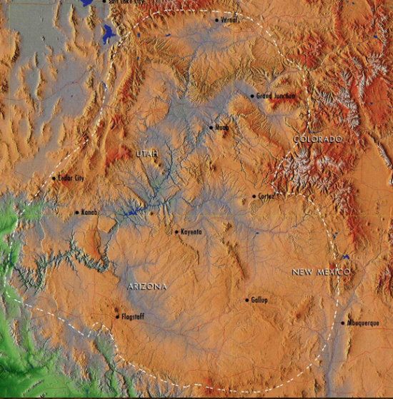
Where to Begin? From the perspective of the Four Corners Monument, use your imagination and drive for about forty-minutes west of Cortez, Colorado on U. S. 160 (the so-called Navajo Desert skirting across their reservation and the Painted Desert country). Welcome to one of the Southwest gateways and the northwest edge of the Colorado Plateau in this sector.
The desert-Southwest fans out like an immense calico carpet adored with its fractal terrain of plateau's downsized into mesas, buttes and scored by hogbacks and Cuestas (gently tilted sedimentary rock strata). The farther out angular or amorphous shapes in the background seem to recede before they’re encroached upon. If Mother Nature has taken Her time honing the myriad landmark remnants from marine and terrestrial depositional environments, then the network of paved and unpaved roads that cross such a distance as this desert terrain tests the patience of those who want to override the space-time continuum and get to where they're going as soon as possible. In short, the estate of land contained within the Plateau’s boundary lines is utterly sweeping––130,000 square miles. This uplifted territory (see below for an explanation) also puts on quite a show of visual intensity regarding the bounty of its eminent scenic attractions. Keep in mind how entering this province literally raised between the Rockies and Basin and Range Province marks an indeterminate contrast of outlying peripheral places. Such is especially the case where the vertical profile of the Rockies is compared to the homogeneous prairie country east of their elevated flank that’s noticeably devoid of some of the Plateau’s most famous battlements of erosion (plateaus, mesas, buttes, and in some cases, enthralling spires and hoodoos). True, there are eroded remnants beyond the borders of this province. However, only the Plateau fashions its stunning features and saturates its numerous rock formations with an array of colors in a distinctive way. The fashioning is singular to sensational and every scene nothing less than iconic.
Arches National Park's "Delicate Arch" with Moab, Utah's La Sal Mountain backdrop:

The other factor of the Colorado Plateau is the age. In short, the foundation is old and multilayered with environments that were laid down one after the other for nearly 2 billion years. Combined with its well-preserved geologic fabrication––representing features of the landscape that are wrinkled, faulted, and dissected, yet remarkably intact––the impact on the senses is typically visceral. Strangely, the underlying geologic platform encompassing a sizable chunk of the Southwest has traveled across many latitudes and a few longitudes to its present location, starting from below the equator. This movement, the so-called tectonic plate migration, was caused by the North American plate moving northward (starting below the equator). Indeed, most continental plates change locales and some that alter their direction. This subject matter will also be explained further along in this series.
To qualify (in part) the above mentioned uplift phenomenon, the Plateau is classified as an uplifted terrain (caused by a geophysical process known as plate subduction, which will also be explained further along in this series). For now, consider how the ranging territory’s position on the North American continental plate has been above and below sea level over the eons. Then fairly recently in time (from roughly 71 to 41-million years), the aggregate of its domed-shaped territory has experienced episodic uplifting. More than likely there were two or three major pulses in the uplift, while some geologists think there were more.
Presently, the Colorado Plateau averages some 6,000 feet (1,829 m) above sea level. Considering the small to super-sized volcanic landmarks punctuating this province’s mostly sedimentary landscape (for instance, Navajo Mountain overlooking Lake Powell), the Plateau extends over 2 miles (3.2 km) into a rarefied atmosphere. The highest point is Flagstaff’s San Francisco Peaks, rising 12,633 feet (3,850 m) above sea level. This background, as well as numerous facets of the Plateau, once grasped, will help make better sense of the whole. Of course, what makes it all possible, as a fabrication process, is something Nature does best when applying a specialized erosion technique abetted by a typically arid climate. Does the term differential erosion ring a bell? If not, it soon will.
Now that you have somewhat of an idea about the where-what-how-and-why factors let’s continue the tour and learn more about the Plateau's transfiguring (the action in this verb is intentional) topographical features set into an amazing geographic setting like no other place on the planet.
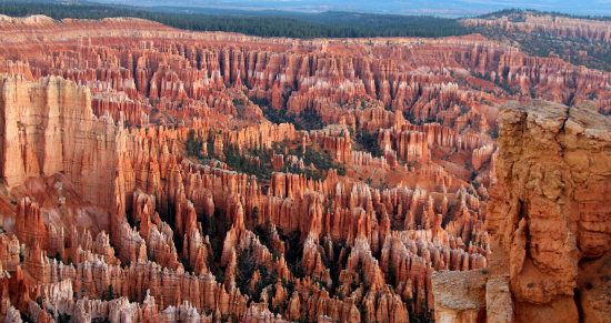
Bryce Canyon National Park, Utah:
The Marvels of Erosion––The Big E Of Mother Nature: Wind and rain, assisted by faulting, have helped break up one large and integrated province of multitudinous layered materials into differing plateau segments. Notably, the characteristic of any rock formation is to break down once erosion sets in. These mostly sedimentary formations throughout the Plateau have therefore eroded at different rates. Thus the basis of the previously mentioned process of differential erosion. The explanation of the process is also easy: alternating weak and resistant rock layers create a step-up profile made from various depositions. Hardened limestone formations therefore tend to form cliffs, while shale and mudstone form ledges and slopes. The castle-like formations of Valley of the Gods and Monument Valley provide token examples how and why differential erosion works the way it does. The Grand Canyon is an even better visual demonstration given its upper layers arranged in a stepped profile.
The net result of erosion throughout the territory creates a nearly uniform appearance (horizontally stacked) made from sandstone, limestone, shale, and mudstone (the latter also known as “conglomerate” or “siltstone”). These deposited materials took place over three long and different geologic eras. The most preserved rocks of this span, which solely belong to the Paleozoic Era (roughly 541 to 251 million years), are revealed in the exposed walls of the apex geologic creation, the just mentioned Grand Canyon. Its ancient building blocks include the even more ancient Precambrian rocks of schist and gneiss (a form of granite) found at the bottom (what geologists tend to call deep time basement rocks). The Grand Canyon also claims the oldest rocks on the Plateau, as well as throughout America. Only parts of the Canadian shield are older (around 3.2 billion years).
Elongate plateaus, desert terraces graced with monumental edifices of rock, and the sporadic and almost fully ruptured volcanoes––the laccolith mountains––are primary landmark features representing the majority of the Plateau’s geologic backdrops, all created by erosion over time. There is visual poetry here and a fair amount of paradox. From low to high places, the Plateau’s geologic display works the mind and stirs all the gates of one’s perception.
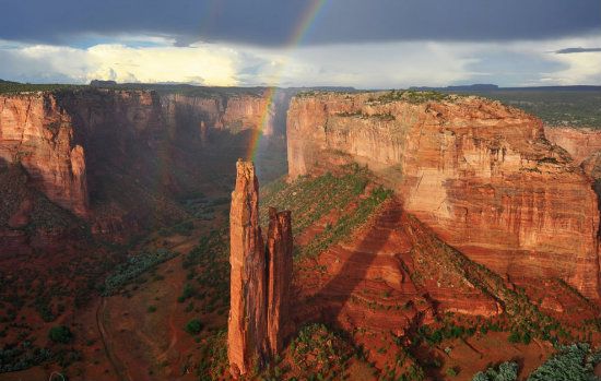
Canyon de Chelly Chinle, Arizona:
Putting A Face On Boundaries: This sector of the United States is bounded by varying landmarks on all sides. In the east, it’s the Rocky Mountains in Colorado, and the Uinta and Wasatch mountain ranges (both branches of the Rockies) in northern and central Utah. Other topographical features are the Rio Grande Rift and Mogollon Rim to the south and slightly to the west. Thence toward the Basin and Range Province in the southwest and west that completes an ostensible circle and shape defining the Colorado Plateau’s askew profile. Isolated ranges of the Southern Rocky Mountains, such as the San Juan range in Colorado and Sangre de Christo range in New Mexico, also the La Sal Mountains in Utah, intermix into the central and southern parts of the Plateau territory.
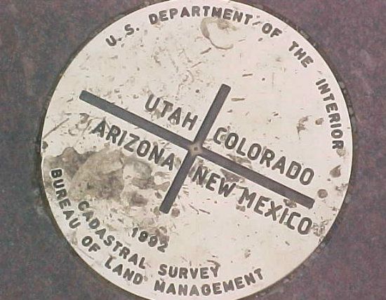
To define the Plateau’s wide and far perimeter, it helps to look at a map of the Western United States and mentally or physically draw a shape around its expansive periphery. As mentioned, a circle might do, yet it would encompass too much terrain that is not flat-lying, mainly because this so-called island in the sky landscape lends its reputation to a horizontally laid geomorphology (meaning its landforms). The circle would also suggest an even amount of territory for each state that comprises the Plateau. However, two of the four corner states (Arizona and Utah) that share distinction in the Plateau’s makeover happen to have the bulk of the 130,000 square miles in their respective jurisdictions. Obviously, this is not the case for both Colorado and New Mexico making up the rest of the Four Corner states in the assembly.
I think what works best to define the boundaries is a silhouette of a head, whose profile is turned to the east. My choice is Ben Franklin sans spectacles. Starting with the top of the famous statesmen’s cranium, which marks the northern boundary of Utah’s Uinta Mountains, draw a slightly irregular line on the map where his balding hairstyle protrudes over his broad forehead. This line represents the central and southern range of the Rocky Mountains, and extends down to where Ben's nose starts somewhere on the Colorado and New Mexico border. This feature of his face is also rather pronounced, having already reached the southern arm of the Rockies, making up Colorado’s and New Mexico’s Sangre de Christo range. Below Ben’s pronounced proboscis the line drops and slightly bends toward Taos, New Mexico, then down to Albuquerque, where there’s a telltale black escarpment to the west of this, the so-called Duke City, called Petroglyphs National Monument. Here is where the beginnings of the Colorado Plateau’s horizontal appearance in the eastern sector really shakes up the view.
Continuing outlining Ben’s profile, the line extends nearly straight down below his nose to where a small indent of his lips shows up, and soon followed by a slightly protruding chin. At this point, however, the line turns to the west, leaving Ben’s lateral silhouette without too much of a chin. Besides, he has a thick neck, so it really doesn’t matter about the chin, right? This segment of the boundary marks eastern Arizona. More specifically, the Mogollon Rim (pronounced “moog-e-yon”), where its most famous southern exposure edges toward Sedona’s comely red rock facade and features. Shaping the lower part of Ben’s big head, which, as a drawing, is mostly inside Arizona and Utah anyway, here the line bends slightly north and west, then ends where the Grand Wash Cliffs mark the western terminus of the Grand Canyon (at the start of Lake Mead). From there the line is somewhat uneven, though it generally heads north to where it merges with western Utah’s Wasatch Mountain range, then back to the starting point, there at the Uinta Mountains.
So now you have an idea and an image to keep in mind when defining the geographic boundaries of the Colorado Plateau. But I haven’t explained why this province earns this designate named after the State of Colorado. Not yet. I’ll keep you guessing and that way you’ll continue reading, I’m thinking.
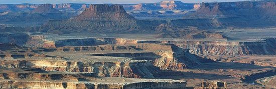
Canyonlands National Park Moab, Utah:
Here It’s Mainly About Geology: As was already explained, the Colorado Plateau encompasses a large lay of land, whose divergent topography includes parts of Colorado, New Mexico, Arizona and Utah. This congregation is the famed Four Corners States of the southwestern United States. This territory is the second highest plateau on the planet, and in most respects its landscape compared to Tibet’s is as different as night and day. That's the first largest plateau, by the way. The Plateau’s prevailing climate––typically arid and therefore stingy regarding annual precipitation––is also quite a contrast compared to Tibet's much higher precipitation (especially snowfall).
What makes any province unique is a combination of many factors. As mentioned, climate is one factor. Topography is another. There are also many provinces in North American. All are unique and engaging in their own way. What really makes provinces stand out is their respective and relative difference in neighboring provinces, with an emphasis on changing elevation such as accentuates the Plateau’s topographical setting. Its turf is elevated (i.e., the uplifted status) much differently than the Rocky Mountain up-trusted terrain, as well as the Basin and Range's linear facade. (Bear in mind mountains rise vertically, while the Plateau's geologic escapades mark horizontally-placed strata, from oceans and seas to deserts.) As mentioned, though here for the sake of clarity, over hundreds of millions of years the Plateau’s original landscape has been honed and downsized into many smaller landmarks (plateaus, mesas and buttes) The most winsome of the downsizing process entails the erosional remnants, hoodoos. These anomalous formations are cone-shaped, as opposed to the smoother and thinner spires and pinnacles. Combined, all these totem-like marvels are found in various places throughout the province.
The next question you might ask is why was (and still is) the Colorado Plateau so ornately fashioned by the physical and chemical elements of erosion? Actually, you already know the reason: it’s the nature of nature of geology and prevailing aridity that compliments the ongoing fashioning process. But let's take a closer look into this process and learn more.
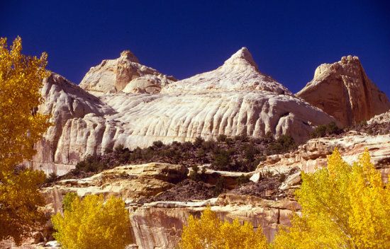
Capitol Reef National Park, Utah:
Nature’s Creative Formula: When one speaks of this distinctive province using this common word, Plateau, exactly what plateau are we referring to? It’s a relevant question asked by some people and deserves an answer. The Plateau is a viable terrain of different elevations, where numerous picturesque landmarks show up, and much like geologic gemstones contained in a single setting. Some folks would claim the entirety of the Four Corners region is the greatest watercolor landscape on the planet, where all the honed features originated from an original template of a seeming overall plateau, then later downsized into various smaller parts. Gracefully downsized, I might add.
Let’s compare plateaus to other landmasses appearing throughout the Plateau. For instance, the aforementioned Cuestas (from the Spanish: "slope"), which typically have a steep slope, and the rock layers are exposed on their edges (known as an escarpment). However, steep cuestas are sometimes referred to as cliffs. Usually an erosion-resistant foundation of rock has a more gentle slope on the other side of the ridge called a dip slope. There are also tilted formations called hogbacks, which are steep, even-crested ridges formed by sharply dipping rock formations. One of the most famous hogbacks in the Plateau is Utah’s San Rafael Swell, where a “swell” is sometimes called a “reef.” Obviously, and given such landmarks, each represents depositions of multilayers of sedimentary rocks that have stacked up in this territory over millions of years, the oldest at the bottom. Hence, the different formations that uniquely form the basis of all plateaus.
The defining template of this territory has produced an old and easily readable textbook of geology just about wherever one looks. That’s because the formations found here have all piled on top of one another and are perfectly preserved (meaning, there is no mountain-building events that typically destroy the geologic record). The various processes of erosion (mostly wind and water) have also no difficulty honing exposed formations especially since aridity is the basis of the Plateau’s prevailing climate.
The previously mentioned horizontal formations laid down at various elevations should now begin to make more sense, and why the Plateau is profiled in such a way. There are also distinct and relatively smaller plateau locales throughout the greater Plateau that break up its former and larger landmass, that is, before this entire territory was uplifted, then gradually came apart due to relentless elements of erosion. Each sector is separated by walls of sheer cliffs (or escarpments) stressed by faults and folding. As these plateaus of differing elevations break down over time, each is progressively downsized into separated into smaller parcels. This point is repeated on the tour because it is the key to why and how the Plateau constantly revamps its features. These adornments of Nature are thus the ubiquitous and aforementioned flat-topped mesas and square buttes, and often with vertical sides.
(For the record, a mesa has a top wider than its height, while a butte’s upper platform is narrower.)
With hundreds of millions of years to craft the geologic features throughout the Colorado Plateau territory, the landscape is not comparable to any other province. It’s foundation is also remarkably stable in all respects. Even faulting hasn’t distorted too much of the geologic record. This distinction is especially the case where volcanic-based mountain ranges rose and were formed by mechanical forces.
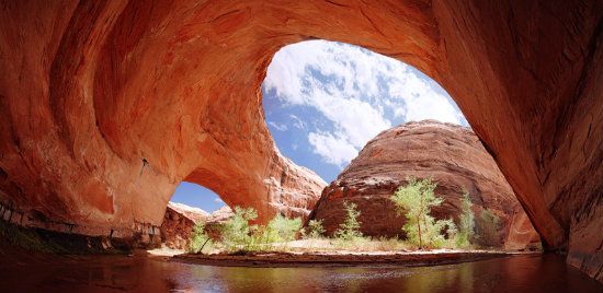
Coyote Gulch/Jacob Hamblin Arch, Utah:
Q.E.O.–– Quo Erat Demonstrandum: Again to mention the point, correlating the Colorado Plateau to the Basin and Range Province is the best way to demonstrate why this region is relatively stable. For example, the geophysical chaos that coincides with the formidable forces of volcanism and thrust faulting, as well as the ensuing consequence of uplifted mountains, these events have all compressed or stretched the land apart in this lower and neighboring province southwest and west of the Plateau. Yet these shaping forces weren’t at work before the Colorado Plateau's uplift began, nor afterward. Moreover, when the entirety of the Basin and Range region underwent its catastrophic renovation, the Plateau remained virtually high and (literally) dry. Hence, its landscape remained intact and was later transformed in an entirely different way. The Plateau’s former mundane features simply became eloquent and engaging. You see, being that the thick and accumulated landscape was jacked up so high in the atmosphere made it possible for erosion, assisted by a dry climate, to prune (sculpt) changing landforms. The transformer was little more than what you already learned on the tour: water and wind and assisted by faulting and folding (of the landscape in various sectors).
Since before the first sea came along in the Cambrian Era, which was at the near beginning of the Paleozoic Era, this is the way things happened here: one depositional environment after another came and went over hundreds of millions of years. In time, the accumulations thickened by thousands of feet. After the epic uplift the entire primal floor plan came apart, though not necessarily in a destructive fashion. It was more like an expressive evolution and alteration of all the features we see on display today. However, the same cannot be said for the down-dropped Mogollon Highlands that preceded the Basin and Range province by millions of years. When this new range of mountains was created, almost in the same place as the former Mogollon Highlands, Nature did not use the same strategy when creating such heights. The same can be said for Rocky Mountain Province. Thus there was a dynamic mountain-building episode, known as the Laramide Orogeny in the western part of the continent that shock and ruptured the planetary crust between 70 and 80 million years ago during the Late Cretaceous Period of the ensuring Mesozoic Era, which ended somewhere between 35 and 55 million years ago. Again to mention this pivotal point, there was no orogensis (mountain-building) during the creation of the Colorado Plateau. Hence, its geologic record was not altered in any way.
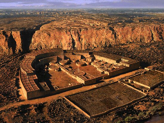
Chaco Canyon, New Mexico:
Nature’s Creative Geophysical Forces: None of what was just explained is meant to say or imply the Plateau did not have its fair share of faulting and volcanic activity to some degree. For example, there are solitary sentinel landmarks that only look like mountains (thus a momentous geophysical change of landscaping brought on by tremendous internal forces below the crust). Navajo Mountain, the La Sals, Abajos and Henrys ranges (all in Southeastern Utah), as well as the iconic Sleeping Ute Mountain overlooking Cortez, Colorado are the largest volcanic landmarks. These island mountains adorning the Plateau were also originally thought to be volcanoes. Instead, they are eroded cores that were caused by extreme forces deep beneath the planet’s surface, which is how volcanoes are born. However, each giant edifice is laccolithic, which means igneous intrusions of molten rock had domed up overlying sedimentary rock strata. Yet no magma (caused by basaltic volcanism) vented beyond the broken crust. Hence, the common analogy of these landforms appearing as great dark boils on the skin of the Earth.
But Nature has, at one time or another, demonstrated incredible power in venting the furor of the planet’s internal heat, which is usually accomplished by means of volcanoes. Volcanoes are also more than noise makers that spew lava and plumes of heavy smoke from their cinder cones. Their conduits act like car radiators, dissipating the heavy heat and building pressure throughout the Plateau. For instance, the cone-shaped stratovolcanoes, which are also called composite volcanoes, are the potentates of Mother Nature’s radiators. Flagstaff’s Mt. Humphreys (the San Francisco Mountains) is a prime example. It has been silent for the last 400,000 years or thereabouts. Yet its former pyroclastic fits roared and choked the atmosphere with megatons of volcanic ash and a soaring plume of thick, gray and poisonous smoke. Popping out in the shadow of this 12,633 foot-high titan are some 600 lesser-sized cinder cones scattered throughout northern Arizona and into the Painted Desert terrain, extending as far north as Moab. Like the Peaks that command the view above Flagstaff, these volcanic landmarks are also quiescent. Actually, the last volcano that erupted in this region was the famed Sunset Crater that blew its handsome top some 930 years ago. Thus some of the volcanoes are obviously dormant and may still act in the capacity of Nature’s feasible cone-shaped radiators.
Volcanic activity is therefore part of the Plateau’s creating and recreating its turf. Another notable landmark worth mentioning is Monument Valley’s El Capitan, also known as Agatha, which in Navajo means “the place of the scraping of the hides.” At 1,225 feet (373 m) in elevation, this soaring volcanic neck, called a diatreme, once served as a conduit––a feeding pipe––of volcanoes throughout this region. Shiprock, New Mexico’s diatrime-turned-pillar of stone, is another similar sentinel see from after and attests to the volcanic activity that affected parts of the Plateau.
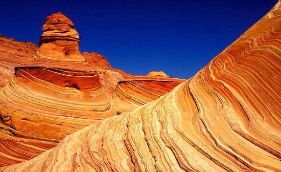
Comb Ridge and the Navajo Blanket (color), Utah

Thicker And Hotter Below, Is It? Perhaps the most important aspect about the Plateau’s ongoing transformation is its thicker crust. It averages around 20,000 feet compared to the Basin and Range’s average of around 14,000 to 16,000 feet. Geologists also theorize how the thickness of this territory (as a whole) may help protect and keep its foundation more stable. As previously mentioned, it’s definitely hotter beneath the Plateau compared to other parts of the North American continental plate. Hence, the Plateau has remained a relatively coherent and recognizable landform throughout some 600 million years of its evolution. All of Nature’s many violent surprises (floods, earthquakes, volcanism, and faulting) have therefore not been the ruination of the Plateau. Certainly, this geological province may have been battered at times and in places. Nevertheless, the wrinkled edges of the province, along with its numerous folded and broken rocks, were mainly localized during the uplifting of the so-called Ancestral Rockies (also known as the Uncompahgre Highlands) about 300 million years ago, and again during the Laramide Orogeny in at least two main episodes, say, somewhere between 70 and 40 million years ago. These tremendous forces that thrust the Rockies and Basin and Range skyward are nonetheless relative compared to the main shaping force of the Plateau––quintessential erosion.
What’s important to know when understanding the difference in provinces, and how each is created, comes down to this finer point: While some land masses around the Colorado Plateau have been tilted, or else were squeezed and broken under enormous pressure, it wasn’t the same for the Plateau’s fabrication. True, there are sporadic, but minor, earthquakes that occur. However, and like a brittle belt, these weaker zones run along the Plateau's western boundary (a line that’s continuous in Utah with the western limit of the Wasatch-Rocky Mountain system). But what happens here by way of faulting is mild compared to, say, California.
Dear Horse State Park (overlooking Canyonlands NP), Moab Utah:

Unparalleled Geology and Geography: Where does the Colorado Plateau take its name? It’s another of those common questions whose answer is found in a river by the same name: the Colorado. This body of water spilling down from the Rockies (near Estes Park in Rocky Mountain National Park) and onto the desert floor (entering near the Moab, Utah sector) is considered the master stream responsible for the Plateau’s stunningly beautiful canyon country. The Plateau is therefore a place and not a state! The multitude of scenic attractions here runs the gambit from the Grand Canyon to Bryce Canyon with a plethora of appealing scenery in between. It’s a finely and meticulously fashioned landscape of the truly unexpected; an idiosyncratic geography where Nature has pulled out all the stops in creating a large repertoire of separate tableaus of scenery on one expansive geologic tapestry. When it comes to Nature’s artistry, the entirety of this province is a visual treat to the senses. You know, sort of like eye candy.
The far reaching layout of the Plateau stretches out like a kingdom of prismatic and surreal singularity. With its inventory of national parks (for instance, the ABC lineup––Arches, Bryce and Canyonlands), national monuments (the 3 C’s––Canyon de Chelly, Cedar Breaks and Chaco Canyon), and an assemblage of archeological and inviolable haunts framing a window to the past (Chaco Canyon, Hovenweep and Mesa Verde). This overall geologic estate is unquestionably unique and historically rewarding in every aspect. For those who revere the truly unexpected, here is the place to experience it.
Other particulars about the geologic significance include the Plateau’s myriad and varying rock formations laid down over the eons. Sedimentary materials, mostly sandstone and limestone, account for the majority of the formations with varying tinctures. But it’s the faulting and folding of rocks, such as one sees in places like San Rafael Swell and Capitol Reef National Park, that literally bends the mind (pun intentional). Here is is indeed the land and landscape of superlatives: baked and patina-stained rock facades and awe-inspiring environments of spellbinding scenery, where deep gashes in the planet’s crust have incised impressive chasms, each scored by little more than rushing water and articulated by erosion. Tricks and treats performed by Nature are the norm here, especially when caught in the sorcery of high altitude lighting and passing shadows that add to the charm of exemplary panoramas imbued with visual poetry, even spirituality for those whose minds and hearts tap into the soul of the Earth.
Escalante Wilderness, Utah
Miscellaneous––What’s in a Name? Some names on road maps of the Southwest are more noticeable and striking than others. This is particularly the case for the Colorado Plateau region. For example, Lukachukai is a more impressionable name than, say, Humbolt. Both are small towns in Arizona, yet in totally different regions, and occupied by totally different cultures. Some names on maps, most of which are Native American in origin, are also attached to plateaus tagged with curious designates. For example, Kaibab, Kanab, Shivwits, Unikaret, Coconino, and Hualapai Plateaus, which surround the Grand Canyon. In Utah, there are the smaller, though elevated, Markagunt, Paunsaugunt, Aquarius, and Wasatch Plateaus to the north and west. The Tavaputs Plateau is closer to the Colorado Plateau’s northern border, near the Uinta Mountains, while the Paria, Kaiparowits, and Table Cliff Plateaus are to the north and east. One other, the Chaco Plateau, is much further east, in New Mexico. It’s also the site of one of the most idiosyncratic and mysterious of all Indian ruins, Chaco Canyon National Historical Park, considered a sacred mecca above all other archeological Native American ruins.
All told, these aforementioned names represent the main plateaus and create the classic hallmark staircase effect mentioned throughout this missive. There are also the names of interesting cliff palisades that have something to do with how and why the Colorado Plateau came apart and formed such sheer precipices. For instance, above Lees Ferry are the Chocolate Cliffs. The Vermilion Cliffs rise above this lower and darker formation. Both formations overlook the expansive Marble Platform and House Rock Valley (to the west). In a much higher elevation are the White Cliffs (Zion Canyon), the Gray Cliffs (Glendale), and the Pink Cliffs (Bryce Canyon), which mark the highest ‘stair’ in the gradually ascending plateaus. Other regions also deserve an honorable mention, especially for the beauty of the towering cliff formations. For example, the Book Cliffs (western Colorado and eastern Utah), Hurricane Cliffs (St. George, Utah), Shinarump Cliffs (Mojave County, Arizona), Straight Cliffs (Kane County, Utah), Circle Cliffs (Garfield County, Utah), the Echo Cliffs (opposing the Vermilion Cliffs, Arizona), and the Grand Wash Cliffs (western terminus of Grand Canyon).
Other alluring names the Colorado Plateau is known for are the San Rafael Swell, the Waterpocket Fold, the Fort Defiance Uplift, the Zuni Uplift, Comb Ridge, and the Monument Upwarp.
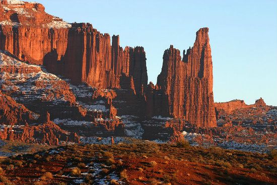
Fisher Towers, Utah
(FYI: In concert with such geophysical forces that were powerful enough to warp, fold, and uplift the planet’s crust were the flexures that contorted the landscape in various ways wherever the strata had dipped noticeably (monoclines, synclines, and anticlines). Perhaps it was nature’s greatest tool of change that instantly alters landscape when these events happen––faults. Faults throughout the Plateau either raised or lowered formidable blocks of rocks and displaced land masses by hundreds of feet. A geologic phenomenon called overthrusting also occurred in rarer places still, which laid older rocks over the backs of younger rocks. However, those ancient geologic events don’t show up on road maps. For that information consult specialized maps used mainly by geologists who rely on more precise data and detail.)
A Bonus And User-Friendly Geologic Lexicon: The following list sums up the pertinent geologic terms relative to Colorado Plateau:
Aeolian cross-bedding (created or acted upon by wind); agate (a translucent, very finely crystalline variety of quartz); alluvial fans (a sloping, spreading mass of gravel and sand deposited by a water source); anticline (folds that are convex upward, with the oldest rocks near the center); arroyos (desert gullies with near-vertical banks); badlands (barren, rough topography in arid areas with soft sedimentary rocks that contain swelling clays such as bentonite); bajadas (coalescing alluvial fans extending from a mountain base into a surrounding valley); breccia (volcanic rock cemented together with lava or ash); caldera (a large basin-shaped volcanic depression formed when a volcano collapses into its partly emptied magma chamber); caliche (an accumulation of hard, crusty rock that's the devil to pay when it rains and your car or truck's stuck in it); caprock (a comparatively resistant rock layer forming the top of a mesa, butte, or plateau); cinder cone (a small, conical volcano formed by accumulating of volcanic ash and cinders around a volcanic vent); clast (an individual fragment or grain in a sedimentary rock formed by the disintegration of some larger rock); columnar jointing (vertical jointing arranged in polygons, due to shrinkage of cooling lava and volcanic ash flows); conglomerate (sedimentary rock composed of rounded, waterworn pebbles of older rock, usually with in a combination with sand); cuestas (hills with a long, gentle slope formed by a resistant caprock, and a short steep slope on cut edges of underlying rock); dendritic drainage (a pattern with steams branching irregularly in all directions); desert varnish — a.k.a. patina (a dark, shiny surface of manganese and iron oxides that characterize many of the exposed rock surfaces throughout the desert); dikes (a thin body of igneous rock resulting when magma intrudes and cools in a vertical crack or joint); dip (the angle at which a stratum or any planar feature is inclined from the horizontal); escarpment (a steep face terminating a high surface); extrusive rock (igneous rock that cooled on the surface, also known as volcanic rock); facies (the general appearance of a rock body as contrasted with other parts); fault (a break in solid rock along which rocks on either side have moved relative to each other); feldspar (the most abundant group of light-colored rock-forming minerals); floodplain (the portion of a river valley that is flooded during excessive runoff); fold (a bend in strata); foliation (layered texture in rock commonly produced by alignment of crystals, as in metamorphic rock such as schist); garnet (a group of hard red-brown minerals occurring in igneous or metamorphic rock); gneiss (a coarse-grained metamorphic rock with alternating light and dark minerals); hematite (a dark red ore of iron); headward erosion (a fluvial process of erosion that lengthens a stream, a valley or a gully at its head and also enlarges its drainage basin); (honeycomb weathering (erosion of sandstone into small, deep pits); igneous (rocks formed by cooling of molten magma); intrusive rock (igneous rock that cools and hardens slowly below the surface); jasper (red chert, a precipitate from limestone); karsts (distinctive type of landscape where solution of limestone has created caves and sink holes); knickpoint (point of abrupt change in the longitudinal profile of a river or stream; laccolith (a sill-like igneous intrusion that domes up overlying rock layers); lava (magma that reaches the surface, or rock hardened from this source); lithosphere (the rigid outer layer of the Earth, made up of the crust and the outer part of the mantle); magma (molten rock in or from the Earth's interior); malachite (a bright green ore of copper); metamorphic (rocks formed from older rocks that have been subjected to great heat and pressure or to chemical changes); obsidian (black, dark gray, or reddish volcanic glass formed by rapid cooling of lava); ore (mineable rock containing valuable minerals, one hopes); orogeny (mountain-building activity); outcrops (surface exposure of geologic materials); pegmatite (coarse-grained igneous rock similar to granite in composition); playa (a dry lake bottom); redbeds (red, pink, and purple sedimentary rocks, usually sandstone and shale colored by hematite); relief (the range of topographic elevation within a specific area); rift (a deep fracture or break in the Earth’s crust where two plates pull apart); rhyolite (light-colored silicic volcanic rock containing small crystals of quartz, feldspar, and mica); scarp retreat (gradual retreat of a cliff face by the forces of erosion); schist (metamorphic rock with parallel orientation of abundant mica flakes); sedimentary (rocks resulting from consolidation of loose sediment that has accumulated in layers); shale (fine-grained sedimentary rock formed by consolidation of clay, silt, or mud); silicic (igneous rock or magma of sixty-five percent or more silica); sill (a thin body of igneous rock intruded between horizontal rock layers); strata (the layering found within sedimentary rocks regardless of thickness); subduction (tectonic plate process in which a dense oceanic plate dives beneath another piece of the Earth’s crust due to plate convergence); syncline (folds that are concave upward); monocline (a fold or flexure in stratified rock in which all the strata dip in the same direction); talus (broken rock that collects at the foot of a hill or cliff); travertine (hot spring deposits composed largely of calcite); tuff (rock composed of compacted volcanic ash); unconformity (a surface of erosion that separates younger strata from older rock); vesicles (bubble cavities in the lava); volcanic ash (fine rock material ejected from a volcano); volcanic dome (a steep-sided, rounded extrusion of thick lava, forming a dome-shaped mass, often within a caldera); volcanic necks (diatremes or an erosional remnant of volcanic rock that once filled a volcano's conduit); welded tuff (ash hardened by the original heat of the volcanic ash and its gases).
These common names used by geologists represent only a portion of the larger glossary that is pretty much standard terms given their jargon and ilk. These words also provide the reader with a basic understanding of some of the key terms that sets one apart from a mere amateur in the field.
Tomorrow’s diary will continue where this tour de educational force leaves off, starting with what makes the Colorado Plateau’s features so colorful.
As always, thoughtful and intelligent commentary is most welcomed.
Rich
http://www.grandcanyon.org/...
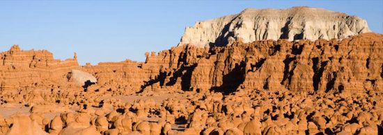
Goblin Valley, Utah: