When you think of this national park, what comes to mind? For instance, this view:
Because there's lots of these features. . .
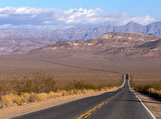
And a huge place with a seeming endless road leading into nowhere. . .

And my God, what if you run out of gas, chips, soda or beer?
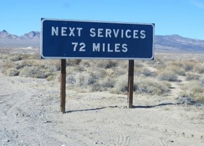
And what if the car breaks down and you find yourself having to go for help with this sort of thing to wonder and worry about?

Well, to all that I say this: If there is any place on this planet that possibly could be a classic misnomer (by way of its designate), it is this huge valley and national park sharing its border with Nevada and California. This two-part diary series will explain what I mean. . .
(Continues after the fold.)
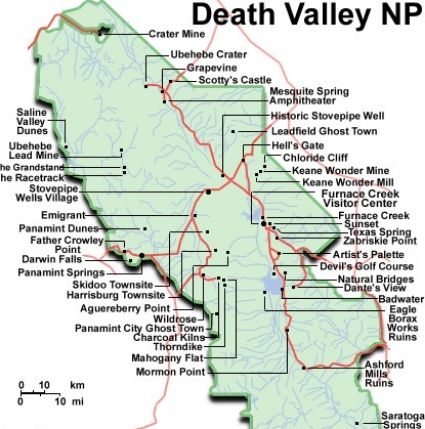
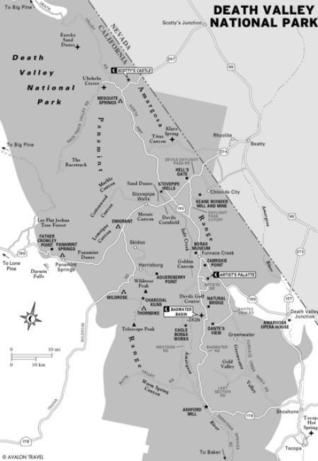
Location/Geography: Partly in California and Nevada. This Great Basin Desert terrain lies east of the Sierra Nevada Mountains. Area: 5,262 square miles encompassing Saline Valley, a large part of Panamint Valley, almost all of Death Valley, and parts of several mountain ranges.
Prologue: I know, what the heck are we doing in this hellish hot place? I mean, it's not even the Colorado Plateau where all the tours and supplement information thus far have set the trend of these weekly diary-missives. Well, I didn't want some of you thinking my bias for the Plateau province is such I don't hold any other province, much less scenic place, in similar high esteem. Fact is, I do. I taught geology and natural history in Death Valley (more of those feisty Elderhostel folks (now called Roads Scholars), but of course I am only teasing about their being feisty. (Actually, anyone who can last with me for about a week's worth of edge-u-kat-n deserves a medal and should be feisty.) Anyway, I love Death Valley and find its overall setting, its geology, and singular atmosphere (both the ambience and how climate works here) utterly spellbinding. Once I even lived in Blue Diamond, Nevada (outside Lost Wages) and I had plenty of time to come here on my own and hike and see the sights and try and figure if there really
On this tour there is going to be lot of stuff to share with you folks, mainly because Death Valley National Park really does have it all: geology, natural and human history, even fables, one of which involved a rather elaborate switch of an extraordinarily wealth man with a stand-in (meaning, a prospector, performer and an all-around con man) to act as the owner of the 'castle,' while the real owner pretended he was a mere guest. More about that intriguing story also follows in this two-part diary.)
By the way, and for the sake of creating an ideal ambience for this tour, I highly recommend wearing a hat, sunglasses, sunblock, and light clothing (which will really put you in the mood for being on the tour). Our destination is one of the lowest settings in the world, certainly one of the hottest (beyond the winter months), and you'd be surprise why this terrain came to be called the name that it is. Actually, relatively few people have died here, at least from the historical perspective. But these days some tourists have an urge to go meet God or something and get themselves into all sorts of trouble. . .all of which could have been avoided had these tragic victims practiced common sense. So, yes, that part of the story also follows.
So, let's take a long drive down a long road and see what this utterly unique national park has to offer. . .other than the scary stuff that keeps some folks away. . .
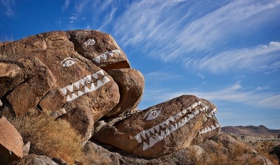
Even the rocks are smiling. . .
Location/Geography: In California and Nevada, this Great Basin Desert terrain lies east of the Sierra Nevada Mountains. Area: 5,262 square miles (13,630 sq. km), encompassing Saline Valley, a large part of Panamint Valley, almost all of Death Valley, and parts of several mountain ranges.

Spotlight: There really is no single description that captures this vast territory, nor can there be. Essentially, it's hotter than the proverbial Hades most of the year. It's also one of the most rugged, scenic and diverse landscapes in North America. In a manner of speaking, the geologic panorama is to die for. The park claims the second lowest elevation below sea level in North America. Focus: geology, human and natural history, and desert ecology.
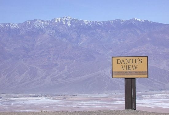
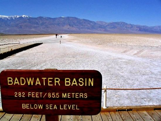
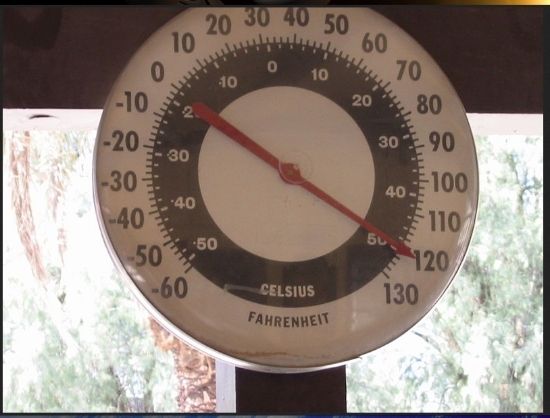
Snapshot: Death Valley stretches out within the broad boundaries of the Mojave Desert and laid down far below towering ramparts. Its reputation is fierce, though the epithet death is a misnomer. Still, it's a great big valley, a basin really, featuring the driest and hottest climate on the continent; also the lowest elevation (286 feet below sea level in North America. Some 550 square miles (885 sq. km) of Death Valley is below sea level. This low sector, called Badwater, is 76 miles east of Mount Whitney (14,505 feet above sea level) ― the highest point in the contiguous United States. These two geographic and topographic extremes creates an amazing contrast of elevations. Death Valley also holds the record for the highest reported temperature in the Western Hemisphere: 134ºF. This reliable reading was taken at Furnace Creek on July 10, 1913, and falls just short of the world record, 136ºF claimed by Al 'Aziziyah in Libya on September 13, 1922. Another incidental record is the valley’s golf course that's part of the tourist ranch at Furnace Creek: It has the lowest elevation of any golf course in the world––214 feet below sea level. Does this mean golf balls, when struck, go farther? Death Valley encompasses an immense territory of extreme topographical features. The expanded national park was dedicated in 1994. Earlier, Death Valley became a national monument in 1933.
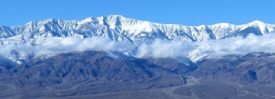
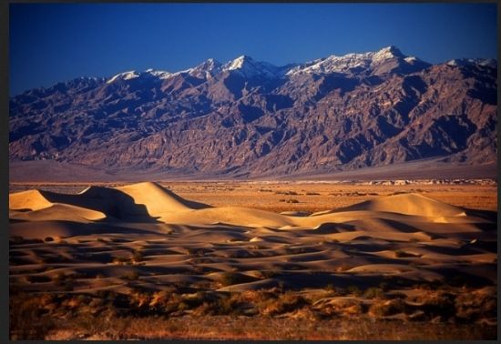
Guided Tour Essentials: Death Valley’s main feature presentation includes the Mojave and Colorado Deserts Biosphere Reserve, sharing borders with California and Nevada, where it lies in the Great Basin east of the Sierra Nevada Mountains. Chiefly, the valley's parched landscape is located in Inyo County, California, stretching from north to south between the U-shaped Amargosa (Spanish word for bitter tasting water) Range (110 mikes long) that rises on the eastern side of the park's perimeter. The highest point of this somewhat elevated range is 8,738 feet. The higher Panamint Range, also running north-south, stretches 100 miles, forming the western wall of the valley. This mountain range is also part of the Basin and Range Province, rising at the western end of the Great Basin. Its highest point, Telescope Peak, boasts an elevation of 11,049 feet above sea level. There are even more mountains to behold in this vicinity. Namely, the Sylvania Mountains trending east and west (7,864 feet) and the smaller Owlshead Mountains (1,683 feet) at the southern end of the park. Approximately ninety-five percent of the park is designated a wilderness, which covers 4,774 square miles. Overall, Death Valley is the largest protected landscape in the Lower 48 states; also the sixth largest park in the United States. At one time, mining was the primary activity in the valley before the area became protected. This facet of the valley's rich history was the highlight of a popular television series, Death Valley Days, televised weekly from 1952 to 1975. And before the television series, the program was broadcast on radio from 1930 to 1945. It’s easily the longest combined media program series ever produced. Seeing or hearing these broadcasts first introduced American audiences to the rugged beauty, and sometimes a lethal environment of this Out West setting. However, the acquired fierce reputation was mainly based on dramatic exaggeration and typical Hollywood sensationalism.
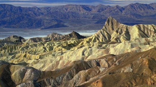
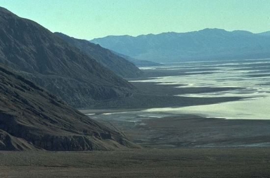
From this salt pan viewing area, Telescope Peak cresting the Panamint Range goes from the lowest to highest points in the lower forty-eight states. Quite a stunning fact when you think about it.
And how many of you folks remember this popular television series:
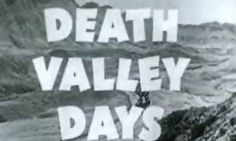
And this actor-turned-president (literally) associated with the series?

And sponsored by this product. . .

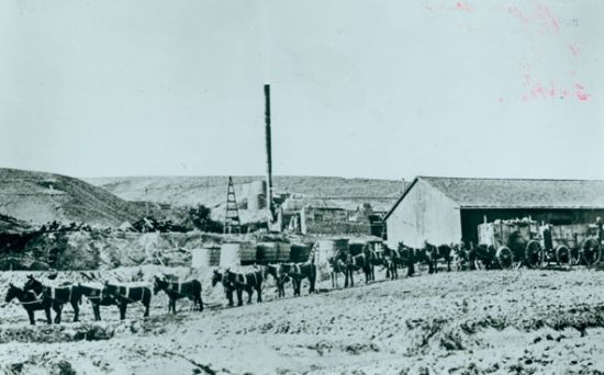
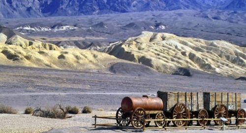
More Essentials (Because DV Is Such A Big Place): The natural environment of this wide and long landscape has been shaped largely by geology. The valley-basin itself is actually a graben (ordinarily, a block of rock that lies between two faults, which has moved downward to form a depression between two adjacent fault blocks). Death Valley represents a huge block of land bordered by parallel faults. The oldest rocks are extensively metamorphosed and are at least 1.7 billion years old. The age nearly rivals that of the Grand Canyon's basement Precambrian rock foundation. Ancient warm, shallow seas deposited marine sediments until rifting opened the Pacific Ocean (the Gulf of California caused by the San Andreas Fault). Additional sedimentation occurred until a subduction zone formed off the coast and, uplifted the region. This primal event therefore emerged from below the sea and partly created a line of volcanoes. Later, the planet’s crust started to pull apart, creating the current Basin and Range Province. Afterward, valleys created by the mountains filled with sediment, and during the wet times between glacial periods, formed huge inland bodies of water such as Lake Manly. Much, much later in time humans walked the earth and Death Valley was what it was: a dry, hot estate laid out below tall mountains. The first documented Anglos to enter this region arrived during the winter of 1849. The group came out West searching for gold and thought they would save time by taking a shortcut to the promising gold fields of California. However, the party ended up getting stuck for weeks in a forlorn place hundreds of miles from their planned destination. Realizing the trouble they were in, someone in the party dubbed the setting Death Valley, mainly because the misguided adventure had cost one man his life. Thereafter, the hugely large and wan valley retained its equivocal designate (tomorrow's conclusion will reveal more about this and other human history accounts). Several short-lived boom towns later sprang up during the late-19th and early-20th centuries, mostly settlements that exploited miners their local bonanzas of gold. However, the only long-term and profitable ore mined was borax, which is a mineral used to make soap, also an important industrial compound. Today, borax is an essential component of high-temperature resistant boro-silicate glass products, for example Pyrex cookware. Twenty-mule teams were also exploited to transport ore out of the valley. The lengthy mule teams also helped to make this ranging territory famous and the subject of books, radio programs, television series and movies (many of them Westerns).

FYI-Trivia: The lowest point on land not covered by water is the floor of the Bentley Subglacial Trench in Marie Byrd Land, West Antarctica: 8,383 feet below sea level. While the foundation is covered by a thick layer of ice, technically its region counts as the lowest land mass. Regarding the Western Hemisphere, although Death Valley's Badwater is considered the lowest point, it turns out there's also misinformation about this claim. Recently, it's been decided that the Laguna del Carbón, Spanish for Coal Lagoon (344 feet), is lowest in both the Western and Southern Hemispheres, and the seventh lowest locale on the planet. But if one considers only the lowest point on dry land, the prize goes to the shore of the Dead Sea with an elevation of 1,371 feet below sea level. Nevertheless, Badwater Basin is certainly the lowest point for thousands of miles. Death Valley's elevation is even more accentuated by its proximity to Mount Whitney, which is 85 miles to the west. The 14,505 feet topographic relief (from Badwater Basin to Mount Whitney's peak) represents the greatest elevation gradient in the contiguous United States, and is the terminus point of the Great Basin's southwestern drainage.
How Big is Big? Most of the big news and scenery in this part of the West comes down to a sprawling, spellbinding and rugged backdrop even if one knows very little about what forces created this desolate landscape. Another factor is the sheer size of this place. Death Valley in the continental United States takes the prize for the largest national park, measuring 3.4 million acres (1,376 sq. km), followed by Yellowstone's 2.2 million acres (8,904 sq. km), the Everglades' 1.5 million acres (6,070 sq. km), Grand Canyon's 1.2 million acres (4,856 sq. km) and Glacier's 1 million acres (4,046 sq. km). These big five national parks claim their respective boasting rights, yet way up north in Alaska, the parks are even bigger. By comparison, Death Valley ranks sixth, Yellowstone eighth, and the Everglades tenth. What’s larger? Wrangell-St. Elias NP is first on the far north list and covets the largest turf, at 13.176 million acres (53,321 sq. km). Denali NP is about half that size and comes in at number three, measuring 6.075 million acres/24,584 sq. km. Obviously, Death Valley's protected land grab is still quite impressive, because its usually cooked turf is huge by any comparison. Besides, it breaks the record for the hottest of all national parks, so that’s saying something worth the bragging.
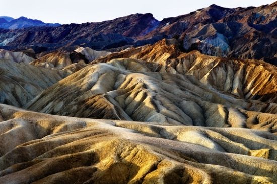
Geology: There are two major sectors in the park––Death Valley and Panamint Valley. Both were formed within the last few million years. Both are also bounded by soaring north to south-trending ranges. Thus the defining aspect of this landscape comes down to orogensis (mountain-building events). These mountains and adjacent valleys follow the general trend of the Basin and Range topography, with one modification: parallel strike-slip faults have noticeably altered the terrain. This geologic event means the fault surface is usually near vertical and the footwall––meaning the underlying block of a fault having an inclined fault plane––moves either left or right, or even laterally, with very little vertical motion. Strike-slip faults perpendicularly bound the central extent of Death Valley. The result of this shearing action is some additional extension––stretching of the planetary crust––in the central part of the valley, which likewise causes a slight widening and more subsidence at the point. Uplift of surrounding mountain ranges and subsidence of the valley floor are therefore occurring simultaneously. A case in point is the uplift on the regional volcanic Black Mountains. This smaller range is essentially a continuation of the Amargosa Range, stretching from California into Arizona. The uplift is so fast (relatively speaking) that the alluvial fans (fan-shaped deposits at the mouths of canyons) are small and steep compared to the much larger alluvial fans coming off the Panamint Range. Still, an accelerated uplift of a mountain range in an arid environment often doesn't allow canyons enough time to cut a classic V-shape all the way down to the stream bed. Instead, a V-shape profile ends at a slot canyon about halfway down, forming what geologists refer to as a classic wine glass canyon feature. Sediment is then deposited on a small and steep alluvial fan.
Edge of the Black Mountains with alluvial fan deposits:
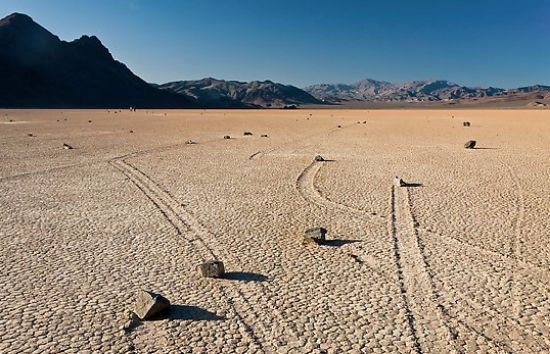
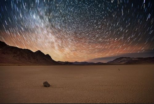
Throughout the western United States, a series of generally north-south running mountain ranges loom over intervening valleys. This landscape feature describes part of Death Valley's geologic events. When a valley has no outlet for water runoff, it's termed a basin, which is the case in many interior valleys of the western United States. Hence, the geographical term Basin and Range Province topography is given for the entire province. When sufficient precipitation over extended periods of time wash small earthen particles into the lowest points in the valley, a flat surface of fine sediment can form. Due to the overwhelmingly arid conditions, the water covering this surface evaporates quickly. A playa is then left behind, which is a formed and hardened pavement that’s absolutely flat and usually salt-laden. Within the park there are two very prominent playas. The most accessible is at Badwater in the southern sector. Almost at the other end of the park is the much more remote Racetrack.
How dry is dry? This desiccated playa scene provides the answer. . .

Although the extreme lack of water in this Great Basin relief topography makes this distinction of minimal and current practical use, it nonetheless indicates that in wetter times a gigantic lake once filled Death Valley (the aforementioned Lake Manly). Its basin was also the last stop for water flowing in the region, meaning the water was saturated in dissolved materials. Thus, the resulting and expansive salt pans in Death Valley are among the largest in the world. They are also rich in minerals (borax and various salts and hydrates). Indeed, the largest salt pan in the park extends 40 miles from the Ashford Mill Site to the Salt Creek Hills, covering some 200 square miles of the valley floor. The best known playa in the park is the above mentioned Racetrack, which is famous for its mysterious moving rock. It's also entirely devoid of vegetation. Incidentally, those so-called sailing stones on the Racetrack playa are a geological phenomenon found only in this location, and possibly the only place on the planet where such strangeness occurs. Without human or animal intervention, the stones slowly and intermittently move across the surface of the playa, leaving a track as they go. Remarkably, the movement has never been seen or filmed in motion. In fact, racetrack stones move only once every two or three years. Most tracks also last for only three or four years. Stones with rough bottoms leave straight striated tracks while those with smooth bottoms tend to wander. The stones sometimes turn over, exposing another edge to the ground while leaving a different sized track in the wake. Mysterious and fun at the same time. Then again, the mystery may have been solved by the claim sailing stones are most likely moved by strong winter winds that can sometimes reach 90 miles-per-hour (148 k.p.h.). Once it has rained enough to fill the playa with just enough water to make the clay pliable, then the stones can be moved by the wind. Because prevailing southwest winds across Racetrack playa blow to northeast, most of the rock trails are parallel to this direction, lending support to the hypothesis that wind is the cause.
I wonder what the Vegas odds are on these moving rocks!
Maybe the cosmos is somehow behind the mystery. Do you think?
The other oddity about these sailing stones is they're not pebbles and such. Still, if the wind really is the catalyst, then there's a lot of mass to move across the playa. . .

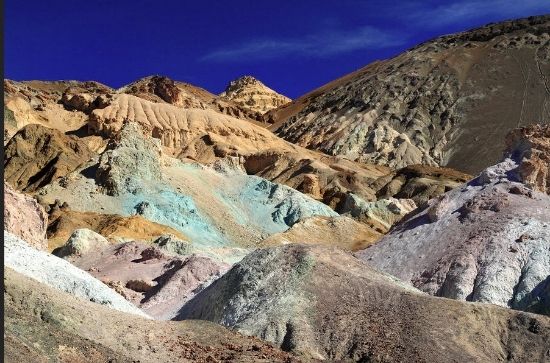
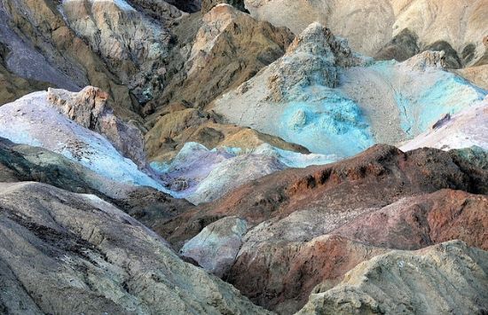
The other notable aspect about Death Valley is its singular geology and the tincture in some of the rocks. Sometimes it seems Mother Nature's artistry used all of Her palette colors. . .
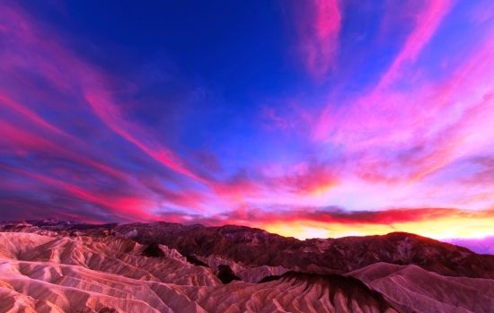
And she can certainly orchestrate a stunning sunset of mesmerizing colors. . .
Why Is It So Hellish Hot Here? As a rule, where the sun heats the ground and heat radiates upward, lower altitudes tend to have higher temperatures. It’s as simple as that. Or is it? Here there are other variables to consider. For instance, elementary climatology teaches the principle: as air begins to rise it's soon trapped by (1) the surrounding elevation and (2) the weight of the air (essentially the atmospheric pressure) above it. Atmospheric pressure is also higher at very low altitudes than under the same conditions higher up at sea level, simply because there's more air (meaning, more distance) between the ground and the top of the atmosphere. When the atmospheric pressure traps the heat near the ground, wind currents naturally arise, thereby circulating very hot air and dispersing heat to all areas despite shade and other factors. This horizontal movement and retention of heat is especially important here in Death Valley, because it provides the terrain's specific climate and geography. The valley is also nearly surrounded by lofty mountain ranges, while the surface landscape far below is mostly flat and devoid of plants. Thus a high percentage of the sun's heat reaches the ground and is absorbed by soil and rock.
Can you even imagine what the miners endured throughout most of the year?
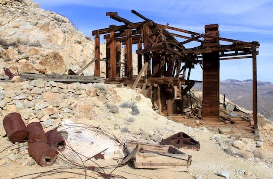
Not to mention what these hard-working guys and gals put up with on any given day:
The physics of the matter comes down to this salient point: When air at ground level is heated, it begins to rise. Moving up and past the steep bulwark of mountain ranges, the air cools slightly, but then begins to sink back down toward the valley. As it sinks, the air becomes more compressed and then reheated by the sun to a higher temperature. Now the air moves up and down the flank of the mountains in cycles and in a circular motion. This Science 101 class description is essentially how a convection oven works, albeit here in the valley it’s a leviathan-sized natural oven. The superheated air also plays another important role: It increases ground temperature markedly. This effect instigates hot wind currents trapped by atmospheric pressure and mountains, and mostly stay within the valley.
Notice this monitor station is in the shade:
It’s precisely these hot winds that contribute to and perpetuate drought-like conditions in the valley. IN short, preventing cloud formations from migrating through its ranging confines. Precipitation is also often realized as virga (an observable streak or shaft of precipitation that falls from a cloud, though eventually evaporating before reaching the ground).
A lovely example of virga:
Now the answer to the opening question has a much simpler answer: Death Valley holds temperature records mainly because it has an unusually high number of factors that lead to high atmospheric temperatures, which brings this discussion to the next topic––the weather.
Climate: Death Valley is the hottest and driest place in North America, and for what reason, exactly? Simply this: a lack of surface water abetted by the low relief of the valley’s ranging topography. The valley is so often the hottest spot on the North American continent that many tabulations of highest daily temperature in the country omit Death Valley as a matter of policy. For instance, on July 10, 1913, a record 134ºF (56.7ºC) was measured at the Weather Bureau's observation station at Greenland Ranch (now the site for the Furnace Creek Inn), which was also the highest temperature ever recorded on the continent as of 2007. Daily summer temperatures of 120ºF (49ºC) or greater are common, as well as below freezing nightly temperatures in the winter. July is the hottest month, with an average high of 115ºF (46ºC) and an average low of 88ºF (31ºC). December is the coldest month, with an average high of 65ºF (18ºC) and an average low of 39ºF (4ºC). The record low is 15ºF (-9.4ºC).
A view of the Furnace Creek Inn:

Now the question can be asked: Why is it predominantly dry here and with such exaggerated temperatures? Apart from the typical air current patterns mentioned earlier, the mountain ranges have something to do with this phenomena (the highest within the park is the Panamint Range, with Telescope Peak the highest summit at 11,049 feet). Death Valley is in a transitional zone in the northernmost part of the Mojave Desert, consisting of five mountain ranges removed (isolated) from the Pacific Ocean. Three of these are significant walled barriers: the Sierra Nevada, the Panamint Range, and the Argus Range located in Inyo County between the Coso Range and Panamint Valley; also, the Panamint Range to the east.
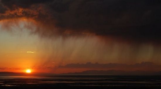
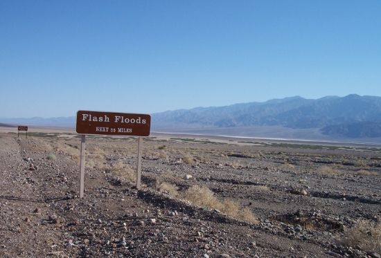
Air masses tend to lose moisture when forced up and over mountains, in what climatologists call a rainshadow effect. Hence, what rainfall really ever exists in the valley? The exaggerated rainshadow for Death Valley region therefore makes it North America's driest spot, receiving just 1.5 inches of rainfall annually at Badwater (some years fail to register any measurable rainfall). Annual average precipitation varies from 1.92 inches overall below sea level, to over 15 inches in the higher mountains surrounding the valley. When rain does arrive, intense and ephemeral storms rake the region. These heavier downpours also cause flash flood episodes, which in turn remodel the landscape and sometimes create shallow temporary lakes. While the drama of flash floods may be awesome to watch, most of the water is wasted, because it’s running too fast to saturate the ground and replenish soil.
These warning signs are common throughout the valley. . .
And in the distance a storm approaches, starting with the lovely and awesome rain bearer clouds, seemingly benign. . .
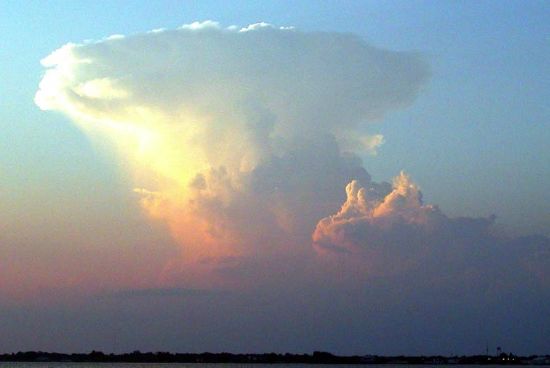
And despite the warnings, despite the typically parched and cracked terrain, despite what seems too far away to matter in the long or short run (those lovely and awesome clouds), people still miss the mark of common sense and end up paying for the mistake with their lives:
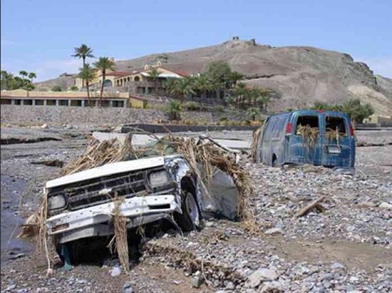
P. S. Notice the Furnace Creek Inn in the background and how close these victims were to safety! I mean, had the driver not attempted to cross the raging water caused by the flash flood.
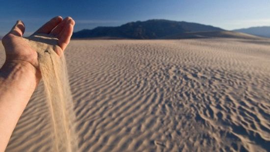
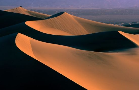
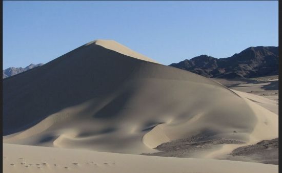
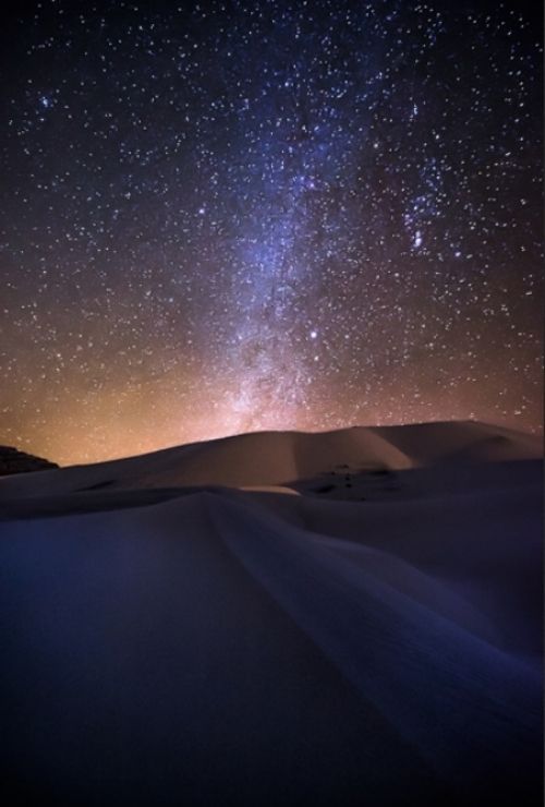
The hot, dry climate has another downside to it, making it difficult for soil to form. The dominant erosive force in arid mountainous areas is the down-slope movement of loose rock, resulting in skeletonized ranges (mountains with very little soil on them). Sand dunes in the park, while a marvel to look at, are not nearly as numerous as one would expect, that is given the dryness. One of the main dune fields, near Stovepipe Wells in the north central part of the valley, is primarily quartz sand. Another dune field is just 10 miles (16 km) to the north and composed of travertine sand. Yet another dune field is near the seldom-visited Ibex Hill in the southernmost part of the park, just south of the Saratoga Springs marshland. These dune fields remain fixed (more or less) since prevailing winter winds come from the north, then shift from the south during summer.
Ibex Hill sand dune sector:
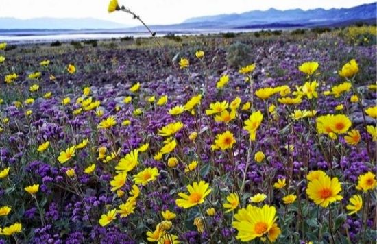
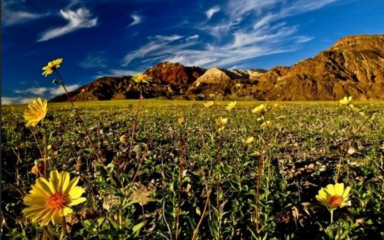
Apart from these norms, there are rare exceptions to the dry nature of Death Valley. In 2005, for instance, an unusually wet winter created a temporary lake of sorts in Badwater Basin. This startling contingency of standing water then led to the greatest wildflower season in the park's history. Indeed, there were so many photographers vying for favored photography spots that park rangers were summoned to break up skirmishes among them––all for the sake of having that special photo of a special flower!
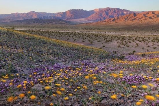

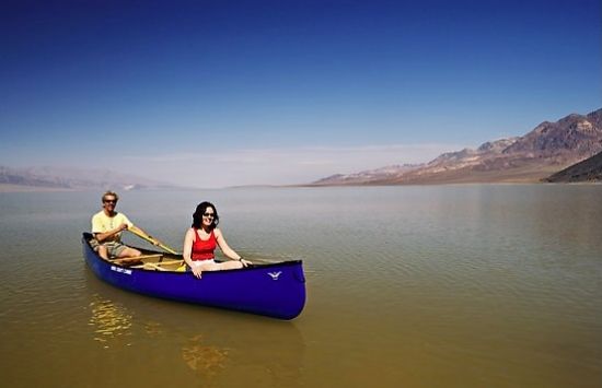
Incidentally, there are rare gully washer years (such as 2005) when Nature's spigot pours it on and huge lakes form:

Sometimes deep enough to do this sort of mirage-like activity:
And when Nature's bounty of water does flow there is an explosion of flower and color in Death Valley!
Meanwhile, here's some parting shots to add to your memory banks. We'll conclude the tour starting tomorrow. . .this time covering more of Death Valley's interesting human history.
End of the trail for these folks, maybe?
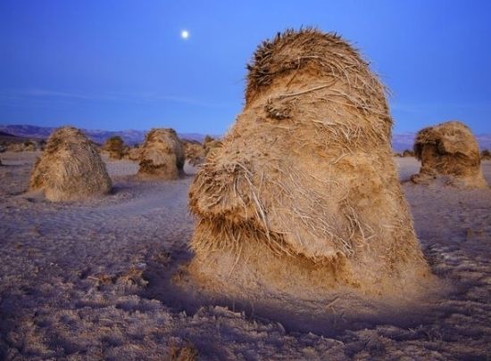
The aptly named "Devil's Cornfield," which is actually tightly clumped arrowweed (Pluchea sericea) member of the sunflower family:
And a big hee-haw y'all from these long-ered haulers (here posing for a modern day photo shoot):

As always, your thoughtful commentaries are welcomed.
Rich
http://www.nmstarg.com/...
http://www.grandcanyon.org/...
