In the wake of my diary about a month ago about the New Jersey State Senate, I was thinking of other states, states where Republican strangleholds on their state senates are largely due to gerrymandering. Michigan is a prime example of this. Despite the fact that Michigan is a blue state, the Republicans not only control the state senate but have a two-thirds majority: 26 Republican seats to only 12 Democratic seats. Now some of that is due to the disastrous 2010 elections allowing Republicans to pick up (or hold) several Democratic-leaning seats, but it is more about the gerrymandering. The rules for Michigan’s legislative redistricting are quite similar to those for New Jersey: No towns or cities can be split unless absolutely necessary, and all deviations must be under five percent (which for Michigan is about 13,000 people). In my map, only four municipalities are split: Detroit (obviously, since it’s the only city in Michigan larger than a district), Livonia (to allow for the creation of an African-American-majority district), Westland (only one precinct is taken out, to allow District 5 to reach Inkster), and Lansing Township (which is not only discontiguous but also allows District 24 to avoid being underpopulated). Besides that, there are no other municipality splits, and I tried to keep county splits to a minimum.
My map would result in Democrats easily being able to get a majority in a neutral year, and possibly being able to hold it in a year like 2010. Michigan is a poster child for midterm dropoff, so I tried to make the Democratic districts as solid as possible while still allowing for as many Democratic districts as possible. As you will see, this was a delicate balancing act, particularly in Oakland County. I present my map and commentary below the fold.
This diary is posted to Daily Kos Elections, an official Daily Kos subsite. Please read the DKE Mission Statement. Our focus is on electoral politics rather than policy or preference. This diary does not invite comment on the ethics of gerrymandering. Welcome aboard!
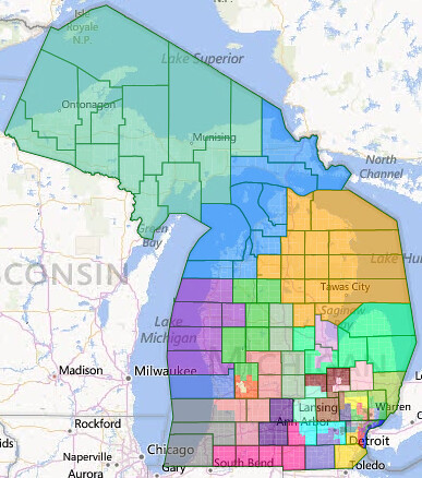
Here is a map of the entire state:
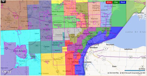
Here is a map of the Detroit area:
District 1 (blue): Coleman Young II (D-Detroit)
Demographics: 39/51/7/1 (white/black/Hispanic/Asian, all VAP)
Prez ’12: Obama 78-21 (not exact due to split of Detroit)
This district stretches along the Detroit River from Grosse Pointe Park to Grosse Ile, picking up several Downriver towns along with a chunk of Detroit. Any African-American Democrat could win here. SAFE D.
District 2 (green): Virgil Smith (D-Detroit)
Demographics: 32/53/10/4
Prez ’12: Obama 82-18 (not exact due to split of Detroit)
This district takes in the remainder of the Grosse Pointe towns, Hamtramck, and Melvindale as well as another portion of Detroit. Bert Johnson lives in Highland Park, which is in District 3, so I’m assuming that he and Virgil Smith would simply switch districts. This is the most Democratic district on my map. SAFE D.
District 3 (purple): Bert Johnson (D-Highland Park)
Demographics: 44/50/2/1
Prez ’12: Obama 80-19 (not exact due to split of Detroit)
This district takes in Highland Park, Dearborn, and Allen Park as well as another big piece of Detroit. This is the second-most-Democratic district on the map. SAFE D.
District 4 (red): Hoon-Yung Hopgood (D-Taylor)
Demographics: 83/8/5/2
Prez ’12: Obama 62-37
This district takes in the remainder of the Downriver towns as well as Lincoln Park, Southgate, Taylor, and Dearborn Heights. Hopgood’s district is moved east, as these mostly-white, Democratic towns are no longer needed for the African-American-majority districts. SAFE D.
District 5 (gold): Open, Randy Richardville (R-Monroe)
Demographics: 79/16/2/1
Prez ’12: Obama 59-40
This district takes in Monroe County and then goes north to include the four southwestern townships of Wayne County, as well as the city of Inkster, and, to get to it, one precinct of Westland. This district is now solidly Democratic, and Richardville, who is term-limited this year, will almost certainly see his successor be a Democrat. SAFE D.
District 6 (teal): Patrick Colbeck (R-Canton), Glenn Anderson (D-Westland)
Demographics: 76/13/3/6
Prez ’12: Obama 61-38
This district keeps Canton and Wayne, but that’s about all it has in common with Colbeck’s current district. Instead, it goes east to take in Garden City and Westland, and west to take in Superior Township and the city of Ypsilanti. It also includes a small portion of Livonia so that the neighboring 7th will have a majority of African-Americans. Anderson is term-limited this year, and Colbeck would lose if he were to run here, so a non-incumbent Democrat is this district’s likely senator. SAFE D.
District 7 (dark gray): Morris Hood III (D-Detroit)? Tupac Hunter (D-Detroit)?
Demographics: 46/50/2/1
Prez ’12: Obama 72-27 (not exact due to split of Detroit)
This district contains the northwestern corner of Detroit, Redford Township, and most of Livonia. It’s not clear whether Hood or Hunter live here or in the neighboring 14th, but Hunter is term-limited, and Hood will have to decide whether he’d rather represent Livonia or Troy. He would win either of the two districts easily. SAFE D.
District 8 (slate blue): Rebekah Warren (D-Ann Arbor)
Demographics: 81/5/5/8
Prez ’12: Obama 63-35
This district contains Lenawee County, and then moves north into Washtenaw, where it takes in Manchester, Scio Township, and Ann Arbor. This configuration of Washtenaw County gets rid of the ridiculous Democratic vote sink in the current version, where all the Democratic areas of the county are in the same district. Warren would still easily win this district. SAFE D.
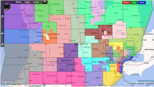
Here is a map of southern Michigan:
District 9 (cyan): Open
Demographics: 79/13/3/3
Prez ’12: Obama 58-41
This district takes in the remainder of Washtenaw County and the more Democratic eastern half of Jackson County. This district’s Democratic bastions are the neighboring townships of Pittsfield and Ypsilanti south and southeast of Ann Arbor. No incumbent lives here, and the Democrats would clearly be strongly favored in an open-seat scenario. However, since Democrats have lost districts with about this partisanship before (cough cough, the Kalamazoo district), I’ll be cautious and say LIKELY D.
District 10 (deep pink): Bruce Caswell (R-Hillsdale)
Demographics: 92/3/3/1
Prez ’12: Romney 58-41
This district includes the more conservative western half of Jackson County, and then takes in four counties that on the southern border: Hillsdale, Branch, St. Joseph, and Cass. Caswell is retiring this year, but any Republican should be able to win this district. SAFE R.
District 11 (lime green): Jack Brandenburg (R-Harrison Township)
Demographics: 91/4/2/2
Prez ’12: Romney 56-43
This district includes the more conservative northern areas of Macomb County, including Harrison, Chesterfield, Shelby, and Macomb. These outer suburbs are not hospitable territory for Democrats. SAFE R.
District 12 (cornflower blue): Open
Demographics: 84/11/2/1
Prez ’12: Obama 58-41
This district is nicely rectangular-shaped and takes in the southeastern areas of Macomb County, including Eastpointe, Roseville, St. Clair Shores, and Clinton. The Democratic lean of the district, plus the fact that Democrats generally hold up better in Macomb even in Republican blowouts, says that this district is SAFE D.
District 13 (dark salmon): Steven Bieda (D-Warren), Tory Rocca (R-Sterling Heights)
Demographics: 83/8/2/5
Prez ’12: Obama 56-43
This district contains three cities and two incumbents. If Bieda and Rocca challenge each other, then the election will likely come down to who can get a bigger margin out of their hometown. However, Bieda has a few advantages. One, Warren is bigger than Sterling Heights (and getting more Democratic, as more African-Americans move in). Two, Bieda has Center Line to augment his totals, while Rocca doesn’t have anything comparable. And three, the district as a whole leans Democratic. Rocca is a strong incumbent with deep roots in Sterling Heights, so therefore I will say that this district is LEAN D. Without Rocca, it would be at least LIKELY D.
District 14 (olive): Morris Hood III (D-Detroit)?, Tupac Hunter (D-Detroit)?, John Pappageorge (R-Troy)
Demographics: 46/43/2/7
Prez ’12: Obama 71-28 (not exact due to split of Detroit)
This district takes in the remaining areas of Detroit, and then goes into Oakland County to include Hazel Park, Madison Heights, and Troy. Hunter and Pappageorge are both term-limited, and Hood might live in the 7th. The Democratic primary here would be dominated by African-Americans, so this district is most likely to be represented by an African-American Democrat. SAFE D.
District 15 (tomato): Open
Demographics: 70/20/5/4
Prez ’12: Obama 62-37
This district takes in Oak Park, Ferndale, and Royal Oak, and then moves north to include Bloomfield Township and Pontiac. No incumbents live here, but a Democrat would easily win this seat. SAFE D.
District 16 (lime green): Vincent Gregory (D-Southfield)
Demographics: 63/28/2/6
Prez ’12: Obama 66-33
This district takes in Southfield, Farmington Hills, and West Bloomfield. Southfield is mostly African-American, while Farmington Hills and West Bloomfield both have substantial Jewish populations. This is the most heavily Democratic district on the map outside of Wayne County, and Gregory would easily win the seat. SAFE D.
District 17 (dark slate blue): Mike Kowall (R-White Lake)
Demographics: 87/4/2/6
Prez ’12: Romney 56-43
This district takes in a swath of mostly conservative western suburbs of Detroit. It includes Northville, Plymouth, Novi, Commerce, White Lake, Lyon, and Milford. Cowall represents much of this place already, and he’d win easily here. SAFE R.
District 18 (yellow): Jim Marleau (R-Orion)
Demographics: 88/3/3/4
Prez ’12: Romney 56-43
This district takes in a bunch of exurbs in northern Oakland County, including Waterford, Independence, Orion, Oakland, and Rochester Hills. This district would suit Marleau just fine. SAFE R.
District 19 (yellow-green): Phil Pavlov (R-St. Clair Township)
Demographics: 94/2/2/1
Prez ’12: Romney 55-43
This district takes in the northernmost row of townships in Oakland County, the northernmost townships in Macomb County, and all of St. Clair County, home to Port Huron. Although St. Clair County voted for Obama in 2008, it went back to its Republican-voting ways in 2012. Pavlov wouldn’t have any trouble here. SAFE R.
District 20 (pink): David Robertson (R-Grand Blanc Township), Jim Ananich (D-Flint)
Demographics: 71/23/3/1
Prez ’12: Obama 61-38
This district includes all of Lapeer County, and then takes in three townships in Genesee County and the city of Flint. Lapeer is light red, but Flint more than outvotes it. A Democrat should never lose this, but if there’s anyplace where the Dems could, it’s Michigan. LIKELY D if Robertson runs, SAFE D if not.
District 21 (maroon): Open
Demographics: 87/9/2/1
Prez ’12: Obama 60-39
This district includes most of the remainder of Genesee County (all except the two southern townships) and more than half of Shiawassee County. Shiawassee is very light blue, and most of the suburbs of Flint are quite Democratic. With no incumbent and no low-turnout cities, a Democrat should easily win this. SAFE D.
District 22 (sienna): Joe Hune (R-Hamburg Township)
Demographics: 96/1/2/1
Prez ’12: Romney 60-39
This district includes all of deep-red Livingston County, the remainder of Oakland County, and the two southern townships of Genesee County. This is the reddest district in the state outside of the Grand Rapids area, and Hune is very safe. SAFE R.
District 23 (aquamarine): Open
Demographics: 78/10/6/4
Prez ’12: Obama 61-38
This district contains the remainder of Shiawassee County and all of Ingham County except for East Lansing and the western portion of Lansing Township (the eastern portion is not contiguous with the western portion). This is a solidly Democratic district, and any Democrat would win here easily. SAFE D.
District 24 (indigo): Mike Nofs (R-Battle Creek), Rick Jones (R-Grand Ledge)
Demographics: 85/8/4/2
Prez ’12: Obama 51-48
This district contains the entirety of Calhoun and Eaton Counties and then the western portion of Lansing Township. This portion of Lansing Township must be in this district, otherwise it would be underpopulated by more than five percent. Both Calhoun and Eaton narrowly voted for Obama, and this district could definitely be a hard-fought one. Democrats have two strong challengers here: state representatives Kate Segal of Calhoun County and Theresa Abed of Eaton County. Republicans have two incumbents here, one from each of the major counties. Just based on the fact that there’s a Republican incumbent here, and that Democrats frequently have trouble winning districts of this partisanship in Michigan, I’ll say this district is LEAN R.
District 25 (pale violet red): Open
Demographics: 83/9/3/2
Prez ’12: Obama 56-43
This district and Kalamazoo County are one and the same. This district’s current senator, Tonya Schuitmaker (R), lives just over the border in Van Buren County, leaving this seat open. For some reason, Democrats seem to have a hard time winning this seat, but since it would be open, I think the Democrats would have a better shot at it. Even better, however, would be if the Michigan Democratic Party could get its act together and actually get its members to vote in midterm elections. Districts like this one really should not be competitive; Democrats should be able to win them easily. Thus, I rate this district only LEAN D.
District 26 (gray): Tonya Schuitmaker (R-Antwerp Township), John Proos (R-St. Joseph)
Demographics: 82/9/5/1
Prez ’12: Romney 51-48
This district contains all of Berrien and Van Buren Counties and the more Democratic southwestern portion of Allegan County. Despite the fact that Berrien has a significant African-American population in Benton Harbor and Benton Township, it seems to be almost impossible for Democrats to win; the only Democrats that I could find who won it recently are Obama and Carl Levin, both in 2008. Even Debbie Stabenow lost it in 2012 while winning statewide by 20 points. Proos would likely defeat Schuitmaker in a Republican primary, since Berrien is substantially more populous than Van Buren. The only reason why I’m not rating this safe R is because Obama won it in 2008, so it can be done, but it would be very hard for a Democrat. LIKELY R.
District 27 (spring green): Mike Green (R-Mayville), John Moolenaar (R-Midland)
Demographics: 95/1/2/1
Prez ’12: Romney 57-42
This district includes the Thumb of Michigan, and then goes west to include part of Saginaw County (particularly the conservative parts) and all of Midland County. Moolenaar is running for Congress (and if he wins, I can see a new meme coming: Moolenaaaaaaaaaaaaar – he’d get the Cravaack and Angle treatment), so Green would have a clear shot at this seat. And at 57 percent Romney, there’s no way that Democrats would be competitive here. SAFE R.
District 28 (plum): Roger Kahn (R-Saginaw Township)
Demographics: 76/14/6/1
Prez ’12: Obama 58-41
This district includes all of Bay County and the remainder of Saginaw County. Kahn is term-limited, and an open-seat scenario should favor Democrats in this Democratic district. However, like District 25 (and possibly for the same reasons), Democrats seem to have a hard time winning this district. However, since it has no incumbent, and both of its state representatives are Democrats, I’d rate it LIKELY D.
District 29 (dark sea green): Gretchen Whitmer (D-East Lansing)
Demographics: 88/4/3/3
Prez ’12: Obama 52-47
This district includes the entireties of Clare, Isabella, Gratiot, and Clinton Counties, as well as East Lansing. Whitmer is retiring, so this would be an open seat. Democratic strength here comes largely from East Lansing and Mount Pleasant, both college towns that are vulnerable to midterm dropoff, so therefore I’d have to rate this district LEAN R.
District 30 (light coral): Judy Emmons (R-Sheridan)
Demographics: 93/2/3/0
Prez ’12: Romney 58-40
This district contains the remaining (conservative) parts of Allegan County, as well as Barry, Ionia, and Montcalm. This is a solidly conservative area, and Emmons should have no trouble winning here. SAFE R.
District 31 (khaki): Open
Demographics: 68/16/11/3
Prez ’12: Obama 60-39
This district contains three municipalities: Grand Rapids, and its two most Democratic suburbs, East Grand Rapids and Kentwood. Kent County is a historically Republican area that is trending Democratic, but unfortunately it is particularly vulnerable to midterm dropoff (see a trend?) as its Democrats are not as permanently engaged as others in the state. That being said, it would be hard for a Democrat to lose this, but out of an abundance of caution I’ll say LIKELY D.
District 32 (orange-red): Mark Jansen (R-Gaines Township), Dave Hildenbrand (R-Lowell)
Demographics: 86/4/7/2
Prez ’12: Romney 62-37
This district includes most of the suburbs of Grand Rapids and nearly encircles the 31st. Jansen is term-limited, so Hildenbrand should be able to win this district easily. SAFE R.
District 33 (royal blue): Arlan Meekhof (R-West Olive)
Demographics: 88/1/7/2
Prez ’12: Romney 67-32
This district is coextensive with Ottawa County, the most Republican county in Michigan and one of the most solidly Republican counties in the entire country. A Democratic presidential candidate has not won Ottawa County since 1864, and in Democrat James Blanchard’s 68-31 gubernatorial landslide in 1986, Ottawa County was the only county he lost. You can’t get more Republican than this in Michigan. SAFE R.
District 34 (lime green): Darwin Booher (R-Evart)
Demographics: 95/1/2/1
Prez ’12: Romney 59-39
This district takes in the northern areas of Kent County, and then extends north to the more Republican counties in the northern Lower Peninsula, including Newaygo, Mecosta, Osceola, Wexford, and Missaukee. Booher won’t have to break a sweat. SAFE R.
District 35 (dark orchid): Geoff Hansen (R-Hart)
Demographics: 84/9/4/0
Prez ’12: Obama 55-44
This district is based in Muskegon County and includes the purple counties to its north: Oceana, Mason, Manistee, and Lake. This is yet another district that the Democrats have had a hard time winning, but I think it can be done. LEAN D if open, TOSSUP with a Republican incumbent.
District 36 (orange): Open
Demographics: 97/0/1/0
Prez ’12: Romney 54-44
This district is basically the northeastern-most part of the Lower Peninsula. It is a generally conservative-leaning land of small towns, whose largest city is Alpena. John Moolenaar represents much of this area now, but his hometown of Midland is in a different district. Any Republican should be able to win this district with ease, though. SAFE R.
District 37 (dodger blue): Howard Walker (R-Traverse City)
Demographics: 91/2/1/1
Prez ’12: Romney 55-43
This district stretches from Traverse City to Sault Ste. Marie, taking in both sides of the Straits of Mackinac. It is the only district on the map that includes parts of both the Upper and Lower Peninsulas, but most of the population is in the Lower Peninsula portion. Walker is retiring, but Republicans would have a hard time losing this district anyway. SAFE R.
District 38 (medium aquamarine): Tom Casperson (R-Escanaba)
Demographics: 93/2/1/1
Prez ’12: Romney 50-48
This is a true Upper Peninsula district, taking in all but two of its counties. This is the only district where the Democratic average exceeded Obama’s 2008 performance, and that shows the UP’s ancestral Democratic roots. This district had been represented by Democrats all the way from World War II until Casperson’s election, so it remains to be seen whether the UP is permanently changed or whether Casperson’s election was an aberration. Thus, I’d have to rate this district as a TOSSUP.
This leaves:
14 SAFE D (1,2,3,4,5,6,7,8,12,14,15,16,21,23)
4 LIKELY D (9,20,28,31)
2 LEAN D (13,25)
2 TOSSUP (35,38)
2 LEAN R (24,29)
1 LIKELY R (26)
13 SAFE R (10,11,17,18,19,22,27,30,32,33,34,36,37)
And remember, these ratings are based on my assumption that the Michigan Democratic Party’s turnout operation will continue to be a mess, and that midterm dropoff among Democrats will thus be quite severe. If the Michigan Dems ever get their act together and start actually turning out their voters in midterm elections, then several of my ratings would become more favorable to the Dems.
If you were paying close attention, you thus saw that of the four districts mostly or entirely in Oakland County, two were Republican and two were Democratic. I hereby present another version of Oakland County that produces a third Democratic district by making the Democratic districts a little less Democratic. Four districts (and a tiny part of a fifth) are changed from the version above.
Here is a map of Oakland County, version 2:
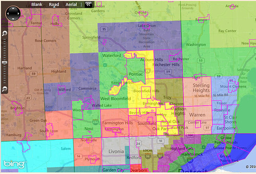
District 15 (tomato): Vincent Gregory (D-Southfield)
Demographics: 65/27/2/6
Prez ’12: Obama 62-37
This district contains Southfield, Farmington Hills, Northville, Plymouth, and Lyon Township. Of the three Democratic Oakland County districts in this version, this one is the most secure, because Southfield is not only heavily Democratic but also sees less midterm dropoff than places like Pontiac. Gregory would win easily here. SAFE D.
District 16 (lime green): Open
Demographics: 70/17/5/6
Prez ’12: Obama 57-42
This district contains deep-blue Pontiac, Democratic-leaning West Bloomfield, and light-red Waterford Township and Novi. Democrats would have a general advantage here, but they’d definitely win if they could ensure that Democrats in Pontiac actually vote. If there was a Republican incumbent here, I’d say lean D, but since there isn’t, I’ll rate this district LIKELY D.
District 17 (dark slate blue): Mike Kowall (R-White Lake), Jim Marleau (R-Orion)
Demographics: 90/3/3/4
Prez ’12: Romney 58-41
This is the one all-Oakland Republican district in this version of Oakland County. Cowall and Marleau would be forced into a primary showdown, and neither of them would have much of an advantage. Cowall would probably win the Commerce, Milford, and White Lake areas, while Marleau would likely win Rochester Hills, Oakland, and Orion. Either would be safe in the general election, however, SAFE R.
District 18 (yellow): Open
Demographics: 81/11/2/4
Prez ’12: Obama 57-42
This district stretches from Auburn Hills to Ferndale, and includes Bloomfield, Birmingham, Royal Oak, and Oak Park. It has a solid Republican base in Bloomfield, but its Democratic base in Ferndale, Oak Park, and Royal Oak is bigger and (usually) more Democratic. Republicans would need great turnout from Bloomfield and low turnout from Oak Park and Ferndale in order to win this, but if that could happen anywhere, it’s Michigan. Again, if there was a Republican incumbent here, I’d say lean D, but since there isn’t, I’ll say LIKELY D.
Also, in this second version, district 19 must gain Springfield Township in order to ensure population equity, but that doesn’t change its partisanship much.
This version would get rid of one safe D district and one safe R district, and replace them with two likely D districts, thus making the table look like this:
13 SAFE D (1,2,3,4,5,6,7,8,12,14,15,21,23)
6 LIKELY D (9,16,18,20,28,31)
2 LEAN D (13,25)
2 TOSSUP (35,38)
2 LEAN R (24,29)
1 LIKELY R (26)
12 SAFE R (10,11,17,19,22,27,30,32,33,34,36,37)
I hope you enjoyed reading, and I welcome any questions, concerns, or comments!

