Of course, despite how it may sound, that's not a traditional Icelandic Christmas song. Don't get me wrong, we have our own versions of American Christmas songs with little Icelandic twists, like Snæfinnur Snjókarl and Hátíð í Bæ (although I think you all need more christmas songs about a giant killer cat that will break into your house and eat you if you don't get new clothes for Christmas).
But I digress.
Vulcanologist Ármann Höskuldsson thinks that our holidays are going to be a bit brighter this year and our fireworks more spectacular with several shiny new volcanoes opening up over the winter. In line with reporting yesterday, he says that this system on Holuhraun is rapidly winding down, will be done within a few days, and will be repeatedly replaced with new eruptions over the course of the winter - hopefully also on the sand, for otherwise they have serious explosive potential.
But is his basic premise even right? And what exactly is going on with the Jökulsár á Fjöllum? What's going on under the surface of Bárðarbunga? Why is Iceland green and Greenland icy? What happened to yesterday's article?
The answer to all of these questions, except for the stupid ones, after the fold on today's edition of Eldfjallavakt!
Ármann thinks that there's a 99.9% likelihood that there will be more eruptions after this ends, which he expects to be soon - he even singles out the earthquake swarm under Dyngjujökull as a likely location, although mentions it could also be in Bárðarbunga herself. But professor of geophysics Magnús Tumi Guðmundsson appears to disagree, stating that the eruption is still going on just as strong as it was a few days ago when visible activity decreased. Likewise, the scientific committee of the national protective services states that ongoing activity on-site has not decreased today. It's hard to evaluate because the lava flow has gotten so large.
So perhaps it's too soon to talk about the end of the current eruption - we'll see after a few days. But the premise is likely correct - so long as the magma keeps flowing, the whatever surface expression is currently present won't change the underlying driving dynamics.
Those of you trying to keep track of how the eruption is faring by watching on the Míla cameras have been disappointed by the fact that you can't see anything due to the thick vog that has descended on the site:

Just be glad that you have a camera between you and the eruption. As per the above report, due to the current levels of danger the researchers have been withdrawn from the site. Icelanders alive today have no experience with these sort of high levels of gas emission, and even the scientists are still learning how to deal with it. But now that it's accumulating at the eruption site, it's making everything worse.
Why is this happening?
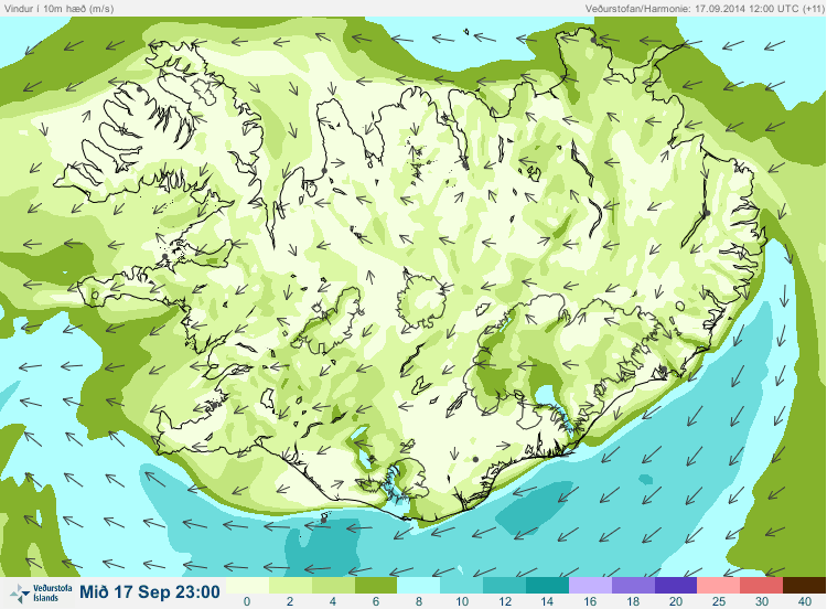
Iceland's typical strong winds from the west-southwest have died down, and thus the transport of the volcanic gases away from the site has died down as well. New towns without meters are getting hit by the Mist, but people seem to be getting used to the drill - shut yourself in the house, close all the windows, and turn up the heat if you can. Of course, the livestock don't have that option, but that situation is just going to be whatever it will be. It's compounded by the fact that the plants are already starting to wither downwind of the eruption (plants are generally even more sensitive to SO2 than humans are). Again, it's very fortunate that this is happening late in the year, not early (although winter exposure is also bad for perrenials).
Without the prevailing winds, what is going to happen to the gas cloud in the highlands? Well, the Met Office has finally come out with a new product: local gas hazards forecast maps. Here's today's:
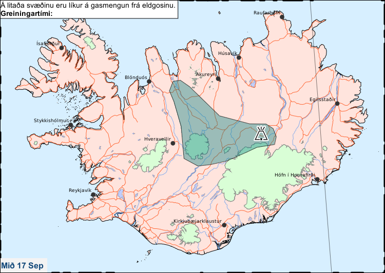
What sort of levels does that blob define? Beats me, I sent the Met Office a question and I hope I'll get a response. If I had to guess, since Iceland uses 300 ppm for "poor air quality" and 600 ppm for "bad air quality", it's probably one of those two cutoff points, with higher pockets within the area. But again, that's purely a guess.
That sort of forecast for today wasn't that bad, that's not a very populated area. However, tomorrow's forecast sucks:
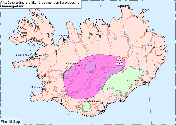
First off, that's getting uncomfortably close to my backyard, and even closer to people in sizeable towns like Selfoss. It covers a couple tens of thousands of people, as well as two of the most popular tourist spots in Iceland, Geysir/Strokkur and Gullfoss.
What will happen? Beats me. This is the first time I've even seen these maps. If it's only several hundred ppm, healthy people most likely won't even feel it, and it might just show up as a statistical blip on health reports. On the other hand, if it gets up into the thousands, there's going to be an awful lot of people feeling pretty lousy, and to people who are already sick, the impaired lung function can be a serious problem.
Normally on this blog, whenever people ask, "should I cancel my plans to do X", "should I reshedule Y", etc because of the eruption, I tell them no, no, at this point we're not come to that. And honestly, since what we're talking about is near the edge of that "blob", we're probably not looking at full force. But personally, if I was a tourist planning a trip to Gullfoss tomorrow?
I'd pick a different waterfall. I'm personally just not to big on willingly walking into plumes of pollution.
But let's change topics from air to fire, water and earth. That is to say, the eruption on Holuhraun.
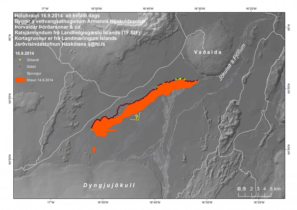
(Credit: Ingibjörg Jónsdóttir)
This is yesterday's map; the lava has progressed since then. As we all know, the lava flow is still moving toward Vaðalda - but only at a slow crawl, having switched more toward growing laterally in branching tongues of lava (those watching Míla before the vog took over likely saw one growing steadily to the south, across Jökulsár tributaries). But let's focus on the far northeastern corner of the flow: where exactly is this endpoint?

As you can see, there's a tall cliff on the north side. But at this point, we're starting to get a small cliff forming on the south side as well, as the river focuses more into the channel to the east of Vaðalda. At present the lava is one day further advanced than this - quite slowly, but nonetheless progressing. This raises the obvious question: How is the water getting to the meter at Upptyppingar?

We had one period where water flows dropped for a day, then surged the day after, but otherwise they've been pretty constant (flows before the eruption had a pretty stable day/night cycle). How's the water doing it, if - in accordance with the map - the lava has flowed fully across the river within this channel?
Looking at the map, I expect that either the flow isn't fully across the river, or that the river has deepened enough that it can flow over the small ridge on the south side. But that will only hold it for so long; the south ridge keeps elevating as you move to the east; eventually it's going to simply be easier to build a lake than flow over it. Then again, if the lava flow totally stops here, the river (and Skínandi) could get a last-minute reprieve.
Mind if I go threefold meta for a second? Here goes: I'm now going to cover the fact that the Icelandic media is covering the fact that the Washington Post is covering the eruption. Anyone want to cover the fact that I'm covering this and make it fourfold-meta? ;)

It's natural to want to see such notable events. But while it's one thing to want to sneak into the poison gas-rich, high-flood-risk zone to see the lava flow, it's a totally different thing to publicly advertise that you'll smuggle tourists up to the eruption. Stupid, stupid people.
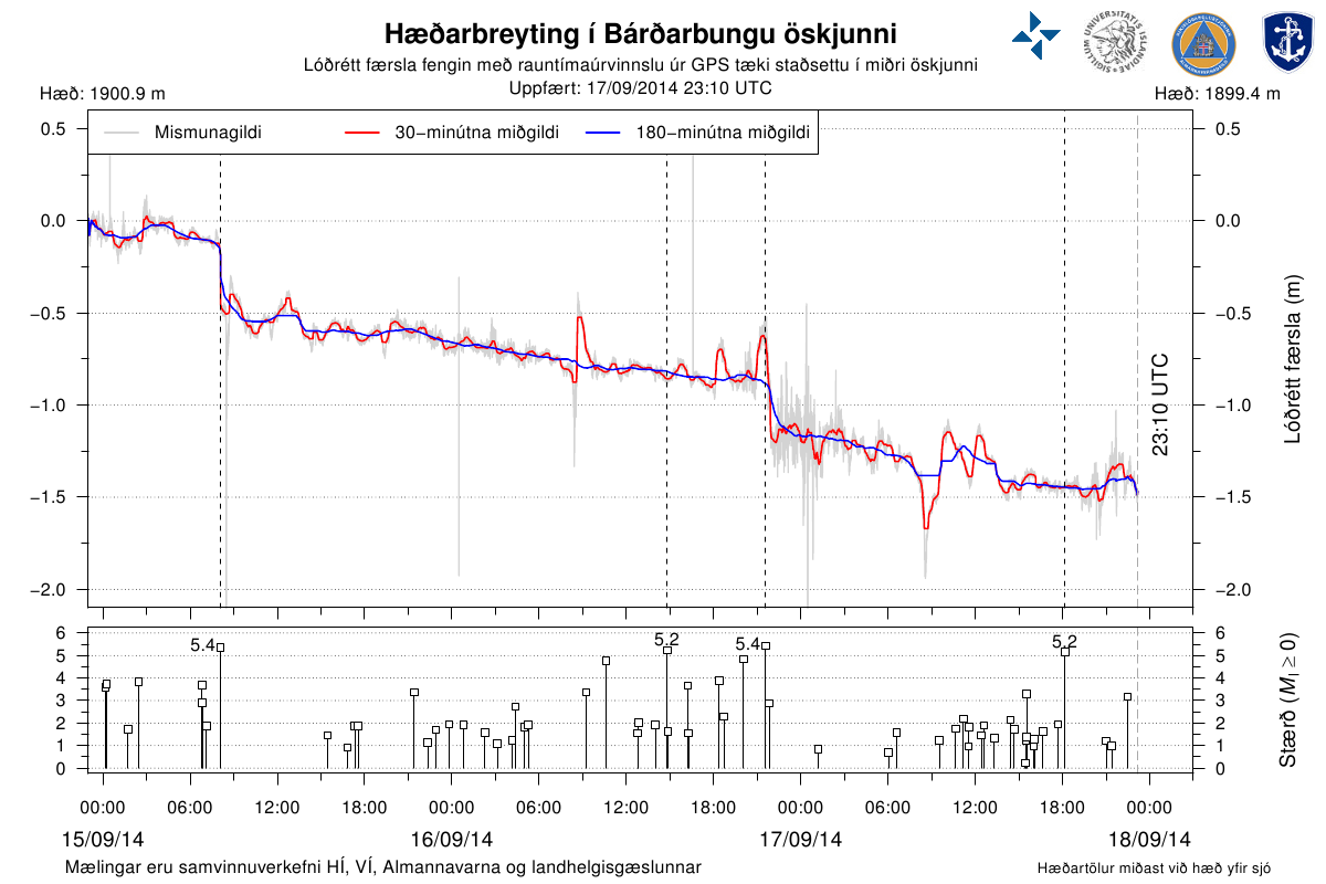
According to the scientific team, the magma flow under Bárðarbunga, Dyngujökull, and Holuhraun is "changing", according to GPS meters. The details or significance of this change is not discussed, but it is reportedly not diminishing.
In the past month, 20 thousand earthquakes have happened in this little part of Iceland, among them 186 3.0-3.9 quakes, 43 4.0-4.9, and 23 5.0+ (that was as of the middle of yesterday, we've had several more big quakes since). To put those numbers in perspective, this little part of Iceland has averaged in the past month one in five 5.0+ earthquakes on Earth (Earth's average rate, 4 per day). In the past couple weeks, it's been more like one in every two to three such quakes on earth.
Subsidence in Bárðarbunga in the past several days has averaged about 50 centimeters per day, coming in fits and starts with the large quakes.
Let's try looking at the past to see what's going on here, to see if it can help us look into the future. There's been lots of comparisons with Krafla, but really Krafla has almost nothing in common with the current eruption - different locations, different eruptive histories, different surface features, different magma chambers, different magma types, etc. But there is a better example we can look to (thanks to Jarðvísindastofnun for pointing this one out): the 1862 eruption at Tröllagígar that formed Tröllahraun ("Troll Lava"). But first, we're going to need to understand the eruptive systems in and around Vatnajökull better. So let's start with a fissure and volcano map:
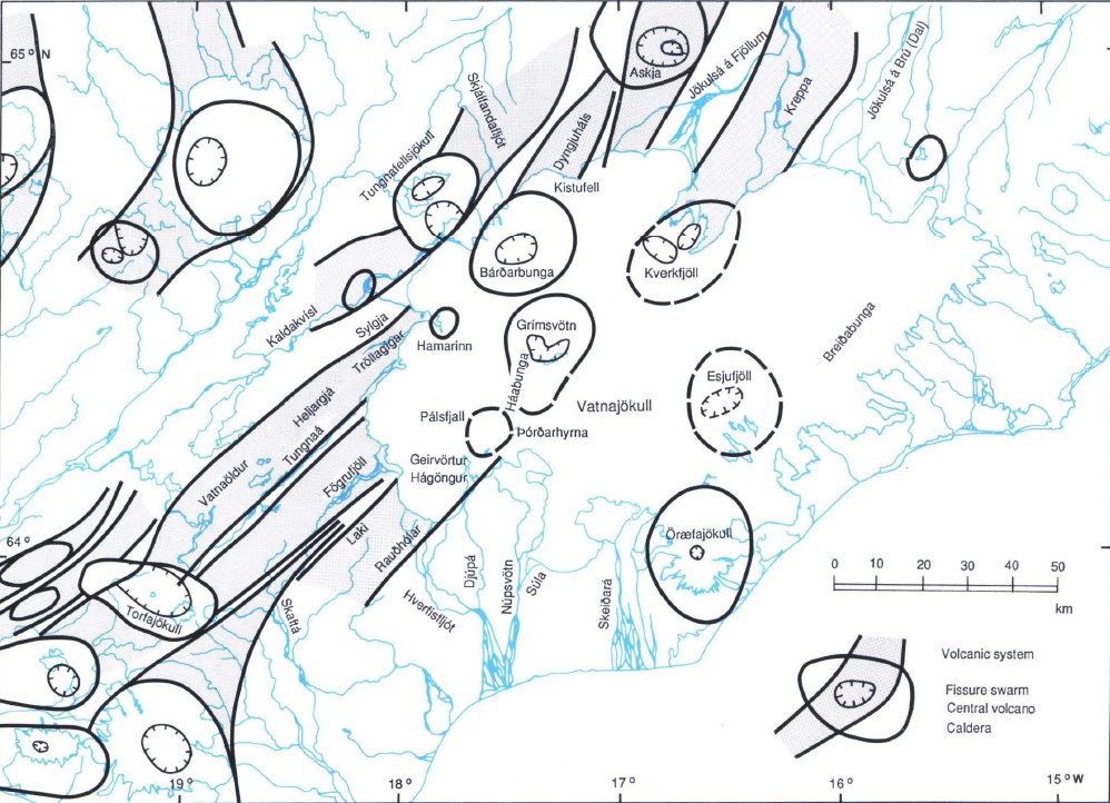
(Credit: "Volcanoes beneath Vatnajökull, Iceland: Evidence from radio echo-sounding, earthquakes, and jökulhlaups", Helgi Björnsson and Páll Einarsson)
This will be useful to refer back to. Now let's focus in specifically on northern Vatnajökull.

(Credit: "Volcanoes beneath Vatnajökull, Iceland: Evidence from radio echo-sounding, earthquakes, and jökulhlaups", Helgi Björnsson and Páll Einarsson)
You may be familiar with this - this is the topography of the surface of the glacier. However, we need to look beneath the ice:
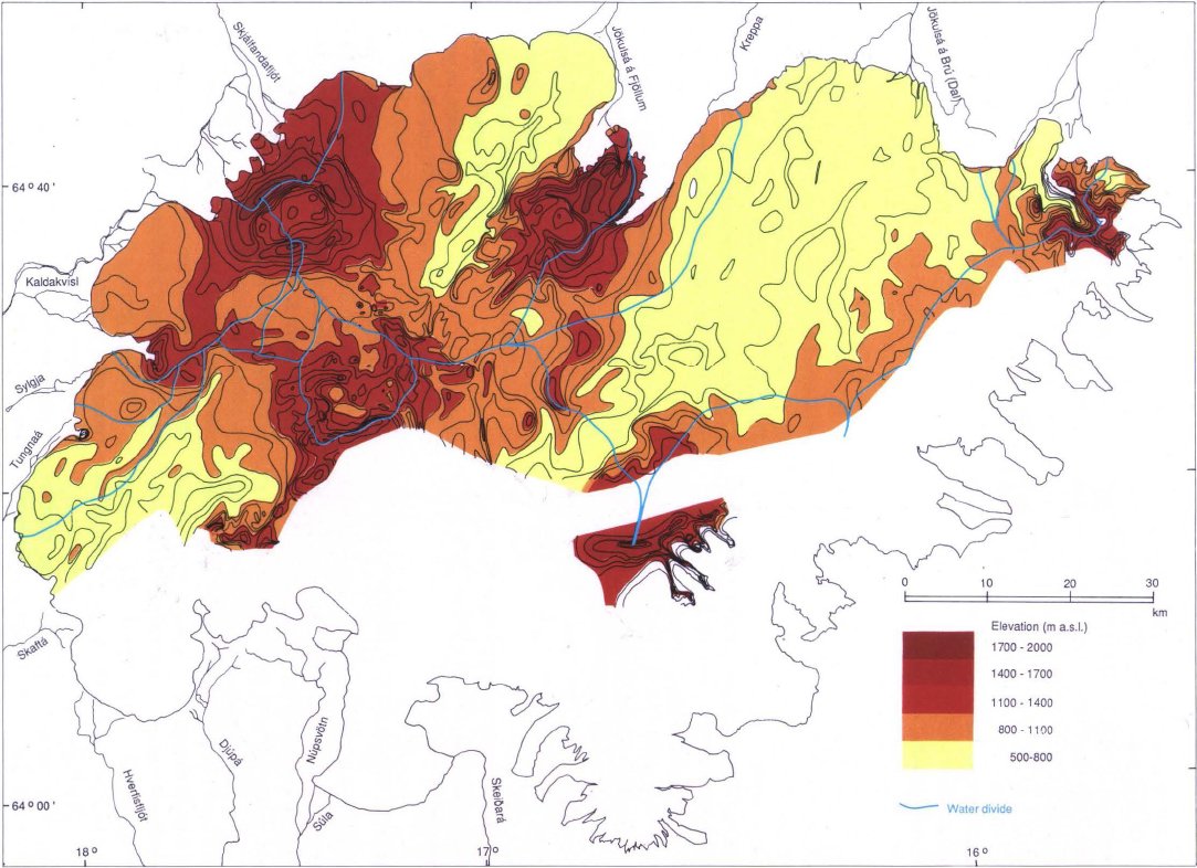
(Credit: "Volcanoes beneath Vatnajökull, Iceland: Evidence from radio echo-sounding, earthquakes, and jökulhlaups", Helgi Björnsson and Páll Einarsson)
First, you'll notice that all of the volcanoes stand out as steep-sided vertical plugs. These are tuyas, the typical (but globally rather rare) formation that occurs when a volcano forms beneath an ice sheet.
Next on the map you'll see a bunch of blue lines. These define watersheds. You'll notice that Bárðarbunga has a rather complex watershed. Eruptions in most places would drain into the Jökulsár á Fjöllum, and indeed Bárðarbunga is widely believed to be the source of the megafloods that have happened on that river a number of times in the past ten thousand years. But eruptions can also flood the Skjálftandaflót, Kaldakvísl, or drain into the internally isolated pockets to the south, which are difficult to predit but would most likely end up in the Skjálftá (Grímsvötn's favorite river to flood).
Now, the Holuhraun eruption is, of course, northeast of Bárðarbunga. But Tröllahraun formed to the southwest, next to Sylgjujökull:
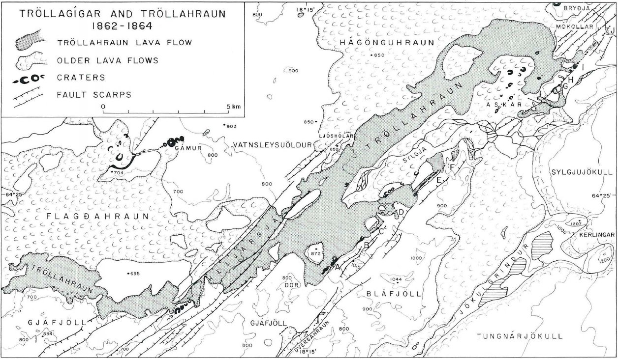
(Credit: "Tröllagígar og Tröllahraun", Sigurður Þórarinson)
As Jarðvísindastofnun sums up:
Tröllagígar lies southwest of Bárðarbunga and west of Sylgjujökli which is a icefall on the western side of Vatnajökull. The Tröllagígar eruption began on the 30th of June, 1862 og then ended, in all likelihood, no sooner than late fall of 1864. The intermittent crater row of Tröllahraun reaches near 13 kilometers long but the flow itself covers about 28 square kilometers. Tröllahraun flowed out from a dike from Bárðarbunga in a similar manner to the current eruption on Holuhraun and the previous Holuhraun eruption, which is believed to have occurred in 1797. Material analysis of Tröllahraun is similar to Holuhraun. The eruption was accompanied by a persistant mist which Magnús Magnússon, district administrator in Sandasel in Meðalland, described in a letter to Magnús Stephensen in Vatnsdal, the plume “with so much smoke and mist that you could hardly see from one farmhouse to the next, and the sulfur came such that the finest of fields were bleached white and all of the grass withered to a third.....”
Tröllagígar was, like Holuhraun, a very gassy eruption, which left a sort of little version of the Laki Haze across Iceland, killing plants and causing discomfort and breathing problems to people and livestock. The formation mechanism is quite similar to the current eruption. And the magma composition is almost a dead ringer.
I have just one problem with the comparison. Tröllugígar erupted 300 million cubic meters over 28 square kilometers in two years. Holuhraun did the same in mere weeks.
We have to ask ourselves, why are the flow levels so incredibly high here and what does it all mean. And I don't have the answers to that. I can simply point out one simple fact, what Bárðarbunga has been doing over the past century and a half:
Nothing.
In the past Bárðarbunga has spent long periods of being very active (for example, the early 1700s). But then she got quiet. Almost strangely quiet. In the over 50 years between when earthquake monitoring in Iceland began in earnest and 1974, there was not a single earthquake of magnitude 5 or larger, and few lesser quakes in Bárðarbunga. But then in 1974, she got "active" again, with 10 magnitude 5 quakes between 1974 and 1990.
Of course, we're gotten 2 1/2 times that many in just a month here.
I'm going to end with a quick story, courtesy of Haraldur Sigurðsson. In 1950, a Skymaster DC-4 named Geysir was flying from Luxemborg with a six-man crew. In bad weather, the pilot made a major course error and flew over Vatnajökull. His error was not noticed until a huge impact hit the plane as it crash landed on the ice. Miraculously, everyone survived. It took two days for the crew to find the rescue boat and its emergency transmitter and managed to use it to send an SOS message to a ship, which relayed the information to rescuers in Akureyri. After living for six days, injured and on the middle of a glacier, all of the crew were rescued.
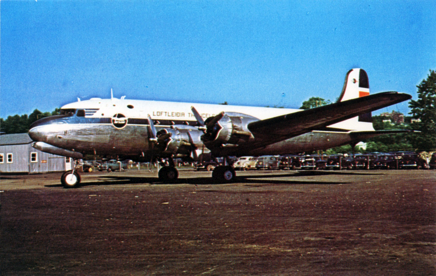
Since then, as one would expect, the plane has been being buried in ice, and is now believed to be about 100 meters down.
In the southeastern edge of Bárðarbunga's crater.
Now, Haraldur personally doesn't think that there will be a caldera eruption. But, he adds, if such an eruption should occur?
Geysir would likely fly again. ;)
Now for a couple videos.
(Credit: Ólafur Haraldson)
(Eruption / Northern Lights)
(Credit: The Telegraph)
---
Lastly, one final note: Several people have asked me if they could send me money as thanks for these articles, which I've always felt uncomfortable about. Really I had no clue when I started writing about the situation that there would be this much interest, although it's great to see a science-related topic having such a good following. But still... rather than donating to me, I was thinking maybe I could set up a DK donation for an Icelandic charity? What do you all think about that? I've checked out several organizations thusfar (Björgunarsveitir, Stígamót, etc), and thusfar none of them have any obvious credit card payment options, they're all setup for bank transfers, which is how most people pay for stuff here.
