This is part of my Gerrymandering series. In this part, I will go state by state and look at the CDs, the process, and whatever else I can find. But I am going to rely on the army of Kossacks to help fill in gaps so that the whole will be more useful to Kossacks who are just reading along.
For my first state, I chose Maine, because
- It illustrates some key problems
- It's not a big state in terms of population
- It probably was not gerrymandered, as the districting was done by independent committee
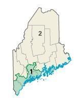
Here are Maine's two CDs
Here's another image, that looks worse here, but has more detail when you click (if it works right):

In my earlier gerrymandering diary I noted that one idea for measuring how gerrymandered a CD was would be to compare it to a rectangle.
Here's a table of the CDs with their northernmost, southernmost, easternmost and westernmost points, areas, the area of a rectangle enclosing the CD, and the ratio
<th>CD</th><th>Northern</th><th>Southern</th><th>Eastern</th><th>Western</th> <th>Area</th><th>Rectangle area</th><th>Ratio</th>
| 1 | 44 38 51 | 43 04 10 | 69 02 15 | 70 56 53 | 3525.25 | 10,355 | 2.94 |
| 2 | 47 26 33 | 43 48 38 | 67 00 00 | 71 04 23 | 27,326 | 49,949 | 1.82 |
Maine has 2 CDs, both of which were won by Democrats in 2002, 2004, and 2006. Redistricting is by an independent commission. Gerrymandering should not be a problem. This illustrates a problem with the measure of gerrymandering: It does not take state boundaries, county boundaries, and water into account. Maine's 2nd CD should have a low index on gerrymandering. Ideas for improving this are welcome
Another method is to look at ZIP codes, or, more precisely ZCTAs (ZIP code tabulation areas). Maine has 400 of these, and only 10 are in both CDs. That measure might allow some comparison between states, but it isn't intuitive.
County maps (see above) are also useful. It is probably desirable not to split a county into two CDs unless the population is so large that it must be done. Therefore, no county should be in 2 (or more) CDs unless
- The county has more people than a CD
- At most one of the CDs into which the county is split has more than one county in it.
Maine has 16 Counties and none of them is populous enough to be a CD by itself.
We then need to consider how counties are put into CDs.
So..... I now have questions for my readers
- Is this project do-able at all?
- If so, which of the above methods seem workable?
- Within those methods, what advice do you have?
- If there is one of you (or more) who'd like to collaborate and knows GIS, that could be very useful
- What else should I consider?
Thanks!
