Deep in the Mojave Desert on the boundary of California and Nevada lays the largest national park in the lower 48 states, Death Valley National Park. At 3.4 million acres it is a million acres larger than Yellowstone, almost Alaskan in size. But nobody would mistake this arid landscape for Alaska, except maybe the similarity of its soaring mountain ranges stretching across miles of landscape.
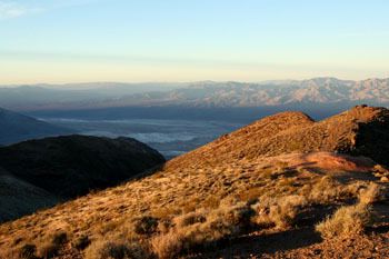
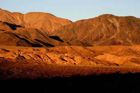
Sunrise at Dantes View, 5,800 feet above Badwater
All photos taken by and copyrighted by Mrs. Ed in Montana
There's the Valley of course, where a wagon train of gold seekers in 1849 made a disastrous choice to leave the Old Spanish Trail to the south and wander into unknown country searching for a shortcut to the gold diggings, and almost paid with their lives. The valley was named for death ever since, although only one member of their party actually perished there. The valley itself holds the lowest point in the western hemisphere at Badwater, 282 feet (86 meters) below sea level, at the foot of the immense eastern slope of Telescope Peak 11,049 feet (3,368 meters) above sea level, one of the greatest elevation ranges in the United States.
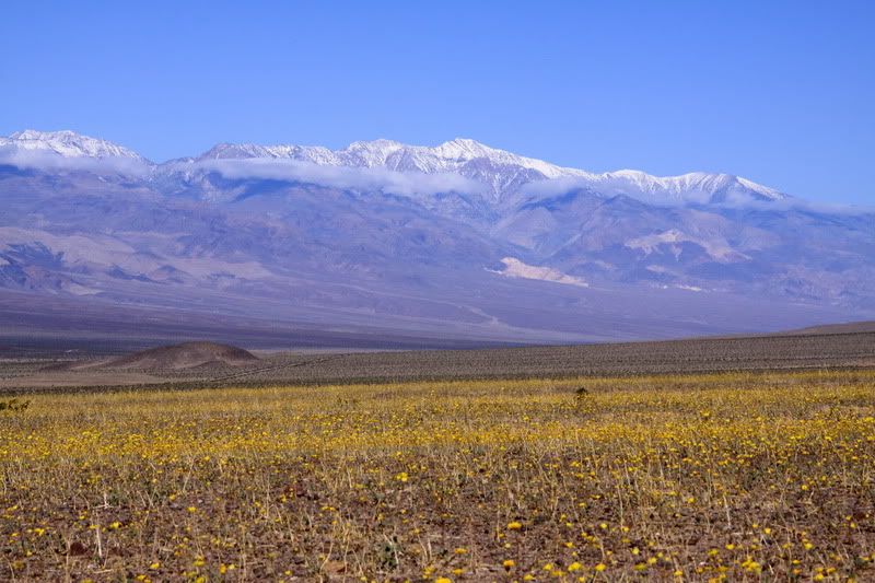
Carpet bloom of Desert Gold, 100 feet below sea level under 11,049 foot Telescope Peak
But as a friend remarked when I visited there with him several years ago: "There's much more to Death Valley than just Death Valley". In fact there's many valleys included in the huge park, most stretching from north to south. Starting on the east side, first there is the higher Greenwater Valley, then the low lying sixty-mile-long Death Valley, followed by the Panamint Valley and finally the extremely remote Eureka and Saline Valleys. All of these valleys are separated by towering mountain ranges, the Amaragosa Range with the Black and Funeral Mountains, the Panamint Range including the Cottonwood Mountains and the near vertical eastern face of the Inyo Mountains. As you might imagine this incredible diversity of landscapes creates an incredible diversity of biological environments. But first a bit about the area's history.
HISTORY
Death Valley and its surroundings might be viewed as a very harsh environment to many visitors, but it is called home by the Timbisha Shoshone, a hardy tribe of Native Americans that have survived here for centuries, and still have rights to traditional gathering activities in much of the park.
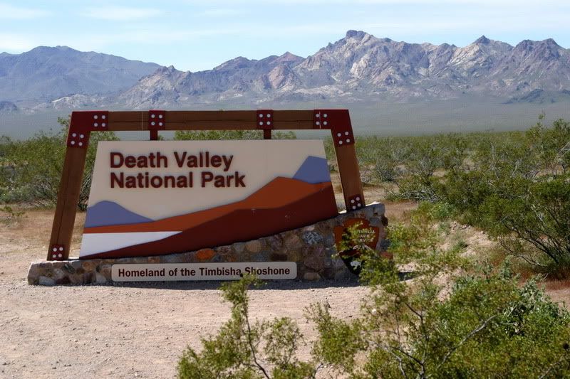
Southeast Entrance at Salsberry Pass
After the misbegotten adventure in 1849 of the lost gold seekers, more miners searching for riches appeared over the next one hundred years finding some gold, silver, lead and borax. The mountains and canyons have the typical western scattering of abandoned mining towns, Chloride City, Leadville, Panamint and Rhyolite to name a few of the more famous.
But none of the hardrock mining operations lasted as long as the borax works in Death Valley. A gentleman named Stephen T. Mather made his fortune there as head of the Thorkildsen-Mather Borax Works, and also fell in love with the harsh desert landscape. In 1916, Stephen Mather left private business to become the first director of the nation's new National Park Service and set the course for protecting many of the famous landscapes in the United States. Two years after his death in 1930, his friend President Herbert Hoover designated Death Valley as a national monument on February 11th, 1933, one of his last acts as president.
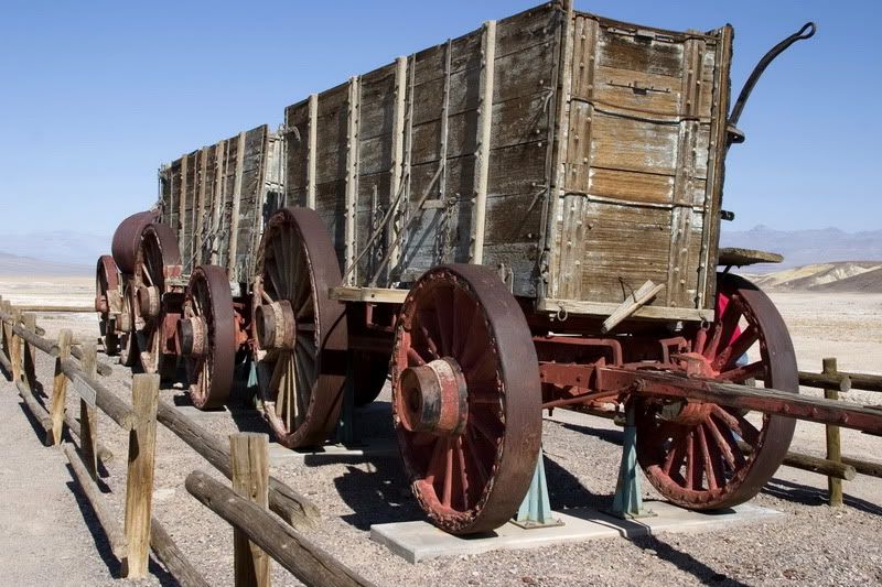
Twenty-mule-team borax wagon
Miners weren't the only European Americans visiting the valley. The oasis at Furnace Creek became a tourist resort in 1927, and the local Timbisha Shoshone helped build many of its ranch buildings. A few miles to the north, the Stovepipe Wells Hotel opened even earlier in 1925, having functioned as a small mining community for decades before that.
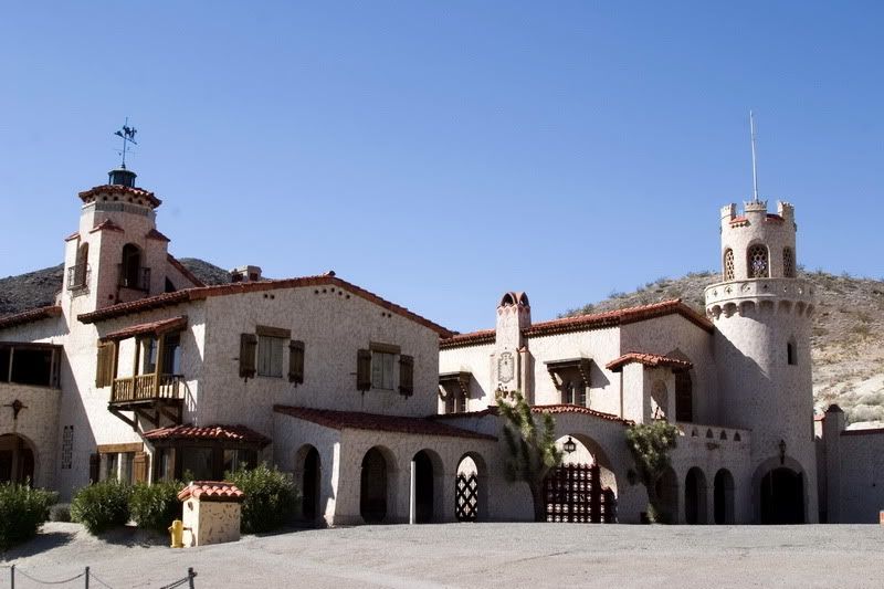
Scotty's Castle
Near the northeastern corner of the present day park lies Scotty's Castle, a Spanish-style mansion started in 1922 by the insurance millionaire Albert Johnson, but named after his friend and sidekick, Walter Scott, a one-time vaudeville performer. The intricately decorated and designed mansion sports beautiful ceramic tile work and amazingly advanced technology for solar water heating.
These early tourist destinations helped push the valley into national monument status.
Death Valley and the surrounding the wild desert is no stranger to recent political controversy. In October of 1994 after more than a decade of grassroots effort, the California Desert Protection Act finally passed the US. House and Senate and was signed into law by President Clinton. This landmark conservation legislation greatly expanded the original national monument, upgraded it to national park status and designated much of it's lands as wilderness. The act also expanded Joshua Tree National Park, established the Mojave National Preserve, and protected millions of acres of Bureau of Land Management lands as wilderness.
But the act became law by the narrowest of margins in the Senate, with Senator Carol Moseley Braun (D-IL) casting the crucial 60th vote to break a republican filibuster of the legislation on the last day of that congress. The Gingrich revolution a month later would place Senate and House in republican hands. The incredible Desert Protection Act of 1994 protected more public lands than nearly any other legislation in history, second only to the Alaska National Conservation Interest Lands Act of 1980.
WEATHER EXTREMES
Death Valley is infamous for having some of the hottest weather on the planet. The second hottest temperature on Earth was recorded at Furnace Creek with a high of 134 degrees F on July 10th, 1913., only surpassed by one higher temperature recorded in Libya in the 1930s. In 2001, the park recorded an incredible 154 consecutive days with high temperatures exceeding one hundred degrees F.
Come prepared for extreme heat in the summer, or wait for the milder weather of the winter and spring.
ENVIRONMENTS
Death Valley bridges the boundary of two of the country's major desert regions, the Great Basin to the north and the Mojave to the south. This geographic diversity results in a biologically diverse desert habitat as well, from salt flats below sea level all the way up to the alpine life zones on the tops of the surrounding peaks.
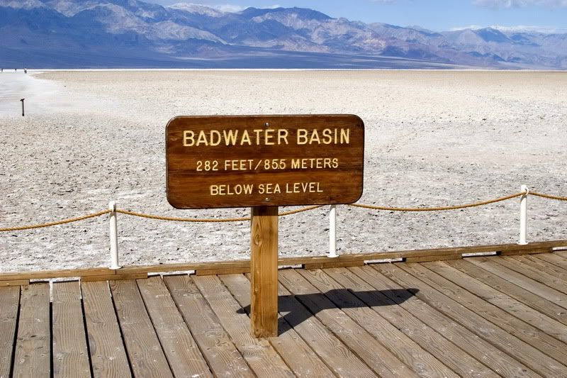
The lowest point, Badwater
Starting at the lowest point, you will find the salt flats, all that remains of the prehistoric lakes that used to fill the Great Basin during the wetter times of the Pleistocene Era. In a really wet year like 2005, the lakes return and people can be seen kayaking on the partially refilled bottom of Lake Manley at Badwater.
These closed drainage basins may seem lifeless, but if you look closely at the streams running into the flats, you may see the remarkable Desert Pupfish. These tiny endangered fish are all that remains from the inhabitants of those Pleistocene lakes, surviving today in water saltier than the sea and as hot as one hundred degrees F.
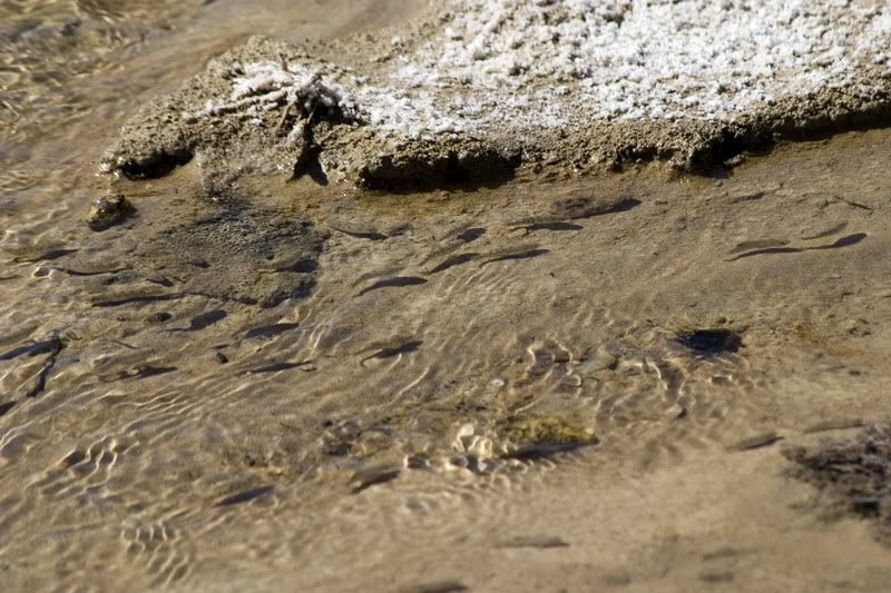
Desert Pupfish in Salt Creek
Above the salt flats are many dune fields, at least seven of which are found in the park, ranging from the small Ibex Dunes near the southern entrance, to the easily accessible Mesquite Flat Dunes near Stovepipe Wells to the immense Eureka Dunes (some of the highest in California) in the far northwest corner. Close examination of these dunes may reveal hidden plants and animals, some of which are found nowhere else in the American deserts.
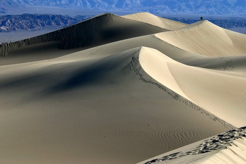
Mesquite Dunes
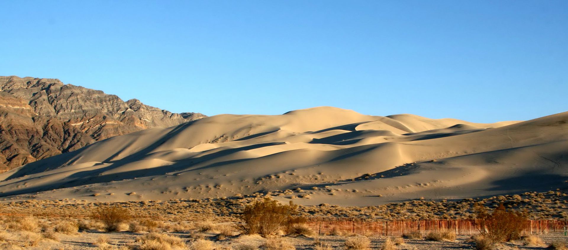
Eureka Dunes
Continuing uphill above the dunes and flats are found the bajadas, the rocky slopes of debris washed down from the mountainsides. These are occasionally covered with spring wildflowers, which since the wet years of 1998 and 2005 have made Death Valley nationally and even internationally famous.
For more on desert wildflowers, check out last weekend's Saturday Morning Garden Blogging.
Emptying onto the bajadas are the steep canyon systems which drain the tall mountains. These canyons, some of which rival the slot canyons of southeastern Utah, are among the park's most popular features. On any day in the winter or spring dozens of hikers may be found exploring the smoothly carved features of Mosaic Canyon, 4WD driving through the deep narrows of Titus Canyon, or hiking to see the dry waterfalls in the more remote Fall Canyon. There is certainly a lifetime of places to explore here.
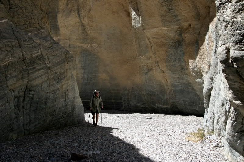
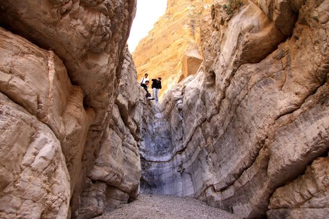
Hiking Fall Canyon
Above the canyons are a few strange features, the desert playas. Playas are shallow lake beds in closed higher altitude drainage basins that have become filled with fine clay particles, making them the flattest geological surfaces on Earth. In the winter during cold, wet storms with high winds, rocks as heavy as four hundred pounds have been known to move hundreds of feet across the playas. The most famous of these playas is the Racetrack in the northern reaches of the park, reached by 25 miles of bone-jarring teeth-loosening rental-car-destroying dirt road. If anything resembles a landing field for alien spacecraft, the Racetrack is it.
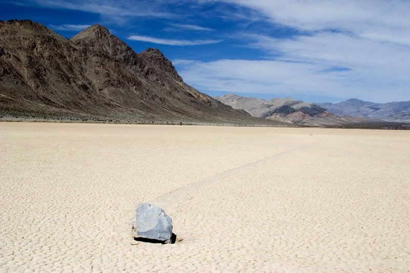
Racing rock at the Racetrack
Far above the playas a few of the higher mountain ranges have remnant coniferous forests, such as those found on Hunter Mountain, the Inyo Mountains and along the crest of the Panamints.
With so much to see and explore, plan for a longer trip or return often, like I have each spring for the past six years to this incredible national park.
Sunrise glow on the Owlshead Mountains
IF YOU GO
Death Valley is a remote and immense national park, and any visit requires some planning. You will see little of the park's beauty from brief drive-by visits and will end up spending the majority of your time in your car. The busiest months are February, March, April and November although a significant number of people brave the extreme heat of summer to drive on through.
Lodging is limited to the Furnace Creek Resort and Ranch in Furnace Creek, the park's headquarters, the Stovepipe Wells Resort and the Panamint Springs Resort. These lodges and motels may be booked months in advance and have no vacancies for weeks at a time.
There are seven developed campgrounds scattered throughout the park, and several of these close down for the extreme heat of the summer months starting in May and lasting until early October. The campground at Furnace Creek takes reservations online, and may be filled months in advance like the park's few lodges.
The true glory of Death Valley can be appreciated by camping in the backcountry along the park's hundreds of miles of dirt roads. In fact, a visitor can camp in many places just off of a dirt road, as long as you are more than two miles from a paved road.

Backcountry camp in Cottonwood Canyon
Make sure to get the Death Valley Backcountry Roads brochure online or at the park for complete backcountry camping tips and regulations. For those flying into Las Vegas and renting a vehicle, remember that rental car agreements prohibit them from being driven off of paved roads, not that that has stopped scores of people from destroying their rentals and having to be rescued in the desert.
Whatever you plan to do in the park, make sure to come prepared, especially with water, gas, food and camping supplies since little of anything is available in the park and the surrounding small communities can be a hundred miles away from the park's main attractions.
Nearby communities with full services are Bishop and Ridgecrest, California to the west of the park and Pahrump, Nevada to the east.
RESOURCES
Death Valley National Park official website for all the basic information on the park.
Hiking
Steve Hall's Death Valley Adventures has a storehouse of information on nearly every canyon in the park.
Best Easy Day Hikes in Death Valley National Park from Falcon Press has good list of easier hikes in the park.
For the hard core hiker or mining history buff, Michael Digonnet's two hiking guides are an amazing resource on the park. They are also a great read to warm up with in the dark cold months of a Montana winter!
Hiking Death Valley: A Guide to its Wonders and Mining Past and Hiking Western Death Valley are available from Desert USA.
This has been the eighth in a series of user contributed features on the national parks. Our previous features are
- Jackson Hole National Monument
- Fort McHenry National Monument and Historic Shrine
- Capitol Reef National Park
- Petrified Forest National Park
- Sequoia and Kings Canyon National Parks
- Dry Tortugas National Park
- Wind Cave National Park & Jewel Cave National Monument
Our next feature will be on Zion National Park. If you are interested in writing a feature about a park, please volunteer at our
sign up form and as your window approaches, you'll be contacted (about 3 weeks before) to finalize your date.
